Property Record
7001 Patronis Dr, Panama City, FL 32408
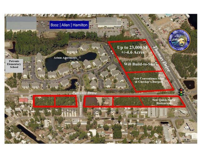

NEARBY LISTINGS FOR SALE OR LEASE
Property Detail
7001 Patronis Dr
30165-400-000
4 4S 15W -7- 69B COM AT THE NW COR OF SW1/4 OF SEC 4 TH RUN S 439.68 TO THE N R/W LINE OF PATRONIS DR. TH RUN E 737.40 TH N23 W 234.16 FOR POB TH CONT N23 W 616 TH E 398.87 TO THE W R/W LINE OF THOMAS DR TH RUN S26 E ALONG SAID R/W LINE 8.46 TH CONT
Multifamilydwelling
Bay
X
Florida
12005C0317J
1
2024
2.08 AC
2025
Panama City
002604
Other Market Areas
36,480 SF
Panama City-Panama City Beach, FL
DEMOGRAPHICS near 7001 Patronis Dr
1 Mile
3 Mile
5 Mile
2024 Total Population
4,784
30,962
53,226
2029 Population
4,989
34,275
58,739
Pop Growth 2024-2029
+ 4.29%
+ 10.70%
+ 10.36%
Average Age
42
44
43
2024 Total Households
1,965
14,099
23,586
HH Growth 2024-2029
+ 4.78%
+ 11.80%
+ 11.42%
Median Household Inc
$57,279
$62,999
$59,750
Avg Household Size
2.30
2.10
2.20
2024 Avg HH Vehicles
2.00
2.00
2.00
Median Home Value
$255,038
$295,636
$273,516
Median Year Built
1992
1994
1993
Nearby Places
Map Layers
Map Styles
 Street
 Aerial
- Restaurants
- Banks
- Shops
- Fitness
- Groceries
PUBLIC TRANSPORTATION
AIRPORT
Northwest Florida Beaches International
DRIVE
WALK
Distance
Northwest Florida Beaches International
34 min
21.8 mi
Freight Ports
Port of Panama City
DRIVE
WALK
Distance
Port of Panama City
7 min
3.5 mi
SALE & LEASE HISTORY
LISTING DATE
SALE/LEASE

Apr 29, 2022
For Lease
Nearby Properties
Address
Land Use
TOTAL SIZE
Lot Size
Zoning
Address
Land Use
TOTAL SIZE
Lot Size
Zoning
96 AC
BC14
Address
Land Use
TOTAL SIZE
Lot Size
Zoning
68 AC
BC14
Address
Land Use
TOTAL SIZE
Lot Size
Zoning
176.88 AC
BC14
Address
Land Use
TOTAL SIZE
Lot Size
Zoning
350,105 SF
16.70 AC
PCB24
Address
Land Use
TOTAL SIZE
Lot Size
Zoning
335,150 SF
17.17 AC
BC05
Address
Land Use
TOTAL SIZE
Lot Size
Zoning
285,798 SF
16.50 AC
BC19
Address
Land Use
TOTAL SIZE
Lot Size
Zoning
648,279 SF
73.10 AC
PC14
Address
Land Use
TOTAL SIZE
Lot Size
Zoning
370,951 SF
19.87 AC
PCB22
Address
Land Use
TOTAL SIZE
Lot Size
Zoning
503,491 SF
79.46 AC
PC12
Address
Land Use
TOTAL SIZE
Lot Size
Zoning
40,690 SF
24.86 AC
BC19
Address
Land Use
TOTAL SIZE
Lot Size
Zoning
38,884 SF
149 AC
BC10
Address
Land Use
TOTAL SIZE
Lot Size
Zoning
254,904 SF
20.60 AC
BC05
Address
Land Use
TOTAL SIZE
Lot Size
Zoning
210,652 SF
19.47 AC
BC19
Address
Land Use
TOTAL SIZE
Lot Size
Zoning
132,433 SF
6.43 AC
PCB21
Address
Land Use
TOTAL SIZE
Lot Size
Zoning
84.50 AC
BC10
Address
Land Use
TOTAL SIZE
Lot Size
Zoning
206,450 SF
12.52 AC
BC05
Address
Land Use
TOTAL SIZE
Lot Size
Zoning
56,045 SF
2.82 AC
BC05
Address
Land Use
TOTAL SIZE
Lot Size
Zoning
208,296 SF
24.72 AC
PC05
Address
Land Use
TOTAL SIZE
Lot Size
Zoning
43,287 SF
7.73 AC
BC04
Address
Land Use
TOTAL SIZE
Lot Size
Zoning
22,462 SF
1.99 AC
BC05
Address
Land Use
TOTAL SIZE
Lot Size
Zoning
216,844 SF
25.60 AC
PCB22
Address
Land Use
TOTAL SIZE
Lot Size
Zoning
145,935 SF
45.63 AC
Address
Land Use
TOTAL SIZE
Lot Size
Zoning
112,780 SF
20.85 AC
BC14
Address
Land Use
TOTAL SIZE
Lot Size
Zoning
143,993 SF
7.27 AC
BC05
Address
Land Use
TOTAL SIZE
Lot Size
Zoning
50,377 SF
1.88 AC
BC05
Address
Land Use
TOTAL SIZE
Lot Size
Zoning
50,354 SF
2.44 AC
BC05
Address
Land Use
TOTAL SIZE
Lot Size
Zoning
55 AC
BC14
Address
Land Use
TOTAL SIZE
Lot Size
Zoning
18,427 SF
2.90 AC
PCB21
Address
Land Use
TOTAL SIZE
Lot Size
Zoning
54 AC
BC10
Address
Land Use
TOTAL SIZE
Lot Size
Zoning
49,004 SF
6.85 AC
PCB21
The World's #1 Commercial Real Estate Marketplace
Connect with us
© 2026 CoStar Group
The information above has been obtained from sources believed reliable. While we do not doubt its accuracy we have not verified it and make no guarantee, warranty or representation about it. It is your responsibility to independently confirm its accuracy and completeness. Any projections, opinions, assumptions, or estimates used are for example only and do not represent the current or future performance of the property. The value of this transaction to you depends on tax and other factors which should be evaluated by your tax, financial, and legal advisors. You and your advisors should conduct a careful, independent investigation of the property to determine to your satisfaction the suitability of the property for your needs.