Property Record
7006 6Th St N, Saint Paul, MN 55128
Current Lease Availabilities
NEARBY LISTINGS FOR SALE OR LEASE
Property Detail
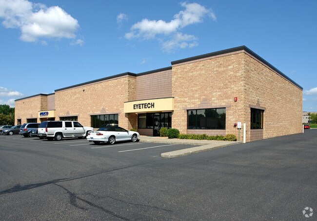
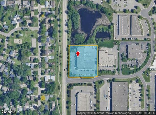
7006 6Th St N
Minneapolis-St. Paul-Bloomington, MN-WI
Oakdale Crossing
32-029-21-23-0005
OAKDALE CITY SUBDIVISIONNAME OAKDALE CROSSING LOT 1 BLOCK 2 SUBDIVISIONCD 58080
Apartment
Washington
X
Minnesota
27123C0130G
1
2025
2.48 AC
2024
East
070910
Minneapolis/St Paul
27,776 SF
DEMOGRAPHICS near 7006 6Th St N
1 Mile
3 Mile
5 Mile
2024 Total Population
8,050
71,660
203,341
2029 Population
8,683
74,070
207,964
Pop Growth 2024-2029
+ 7.86%
+ 3.36%
+ 2.27%
Average Age
41
39
38
2024 Total Households
3,335
27,739
73,677
HH Growth 2024-2029
+ 8.04%
+ 3.54%
+ 2.57%
Median Household Inc
$67,414
$80,344
$80,800
Avg Household Size
2.30
2.50
2.60
2024 Avg HH Vehicles
2.00
2.00
2.00
Median Home Value
$252,727
$290,272
$292,300
Median Year Built
1978
1982
1981
Nearby Places
- Restaurants
- Banks
- Shops
- Fitness
- Groceries
PUBLIC TRANSPORTATION
COMMUTER RAIL
St. Paul-Minneapolis (Empire Builder - Amtrak)
DRIVE
WALK
Distance
St. Paul-Minneapolis (Empire Builder - Amtrak)
14 min
7.1 mi
AIRPORT
Minneapolis-St Paul International/Wold-Chamberlain
DRIVE
WALK
Distance
Minneapolis-St Paul International/Wold-Chamberlain
28 min
16.9 mi
Freight Ports
Port Milwaukee
DRIVE
WALK
Distance
Port Milwaukee
357 min
324.4 mi
Nearby Properties
Address
Land Use
TOTAL SIZE
Lot Size
Zoning
Address
Land Use
TOTAL SIZE
Lot Size
Zoning
267,948 SF
372.92 AC
Address
Land Use
TOTAL SIZE
Lot Size
Zoning
114,777 SF
22.45 AC
Address
Land Use
TOTAL SIZE
Lot Size
Zoning
Address
Land Use
TOTAL SIZE
Lot Size
Zoning
270,348 SF
35.96 AC
Address
Land Use
TOTAL SIZE
Lot Size
Zoning
335,655 SF
Address
Land Use
TOTAL SIZE
Lot Size
Zoning
127,888 SF
141.04 AC
Address
Land Use
TOTAL SIZE
Lot Size
Zoning
47,717 SF
10.10 AC
Address
Land Use
TOTAL SIZE
Lot Size
Zoning
460,439 SF
25.26 AC
Address
Land Use
TOTAL SIZE
Lot Size
Zoning
29.55 AC
Address
Land Use
TOTAL SIZE
Lot Size
Zoning
136,726 SF
Address
Land Use
TOTAL SIZE
Lot Size
Zoning
296,529 SF
31.80 AC
Address
Land Use
TOTAL SIZE
Lot Size
Zoning
228,036 SF
31.11 AC
Address
Land Use
TOTAL SIZE
Lot Size
Zoning
81,006 SF
12.05 AC
Address
Land Use
TOTAL SIZE
Lot Size
Zoning
147,199 SF
32.47 AC
Address
Land Use
TOTAL SIZE
Lot Size
Zoning
181.88 AC
Address
Land Use
TOTAL SIZE
Lot Size
Zoning
85,400 SF
6.43 AC
Address
Land Use
TOTAL SIZE
Lot Size
Zoning
551,440 SF
25.40 AC
Address
Land Use
TOTAL SIZE
Lot Size
Zoning
9.90 AC
Address
Land Use
TOTAL SIZE
Lot Size
Zoning
41,868 SF
6.69 AC
Address
Land Use
TOTAL SIZE
Lot Size
Zoning
262,872 SF
14.22 AC
Address
Land Use
TOTAL SIZE
Lot Size
Zoning
13.43 AC
Address
Land Use
TOTAL SIZE
Lot Size
Zoning
41,201 SF
9.55 AC
Address
Land Use
TOTAL SIZE
Lot Size
Zoning
256,440 SF
27.44 AC
Address
Land Use
TOTAL SIZE
Lot Size
Zoning
86,572 SF
7.92 AC
Address
Land Use
TOTAL SIZE
Lot Size
Zoning
371,200 SF
8.99 AC
Address
Land Use
TOTAL SIZE
Lot Size
Zoning
Address
Land Use
TOTAL SIZE
Lot Size
Zoning
222,374 SF
43.99 AC
Address
Land Use
TOTAL SIZE
Lot Size
Zoning
Address
Land Use
TOTAL SIZE
Lot Size
Zoning
75,825 SF
19.49 AC
The World's #1 Commercial Real Estate Marketplace
Connect with us
© 2025 CoStar Group
The information above has been obtained from sources believed reliable. While we do not doubt its accuracy we have not verified it and make no guarantee, warranty or representation about it. It is your responsibility to independently confirm its accuracy and completeness. Any projections, opinions, assumptions, or estimates used are for example only and do not represent the current or future performance of the property. The value of this transaction to you depends on tax and other factors which should be evaluated by your tax, financial, and legal advisors. You and your advisors should conduct a careful, independent investigation of the property to determine to your satisfaction the suitability of the property for your needs.