Property Record
7002 N 102Nd Cir, Omaha, NE 68122


Save to a Folder
{{folder.Name}}
{{folder.ListingIds.length}} Properties
{{folder.ListingIds.length}} Property
Create a New Folder
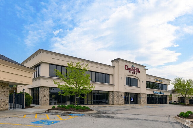
Property Detail
7002 N 102Nd Cir
Omaha, NE-IA
CHERRY HILLS VILLAGE REP 3 LOT 3 BLOCK 0 IRREG 31658 SQ FT
0802-0114-08
Douglas
Regionalshoppingcenterormallwithanchorstore
Nebraska
B and X Area of moderate flood hazard, usually the area between the limits of the 100-year and 500-year floods.
3
2024
0.73 AC
2025
North Central Omaha
007311
Omaha/Council Bluffs
18,666 SF
NEARBY LISTINGS FOR SALE OR LEASE
DEMOGRAPHICS near 7002 N 102Nd Cir
1 mile
3 mile
5 mile
2025 Total Population
10,166
61,661
170,143
2030 Population
10,432
63,270
174,383
Pop Growth 2025-2030
+ 2.62%
+ 2.61%
+ 2.49%
Average Age
36
38
39
2025 Total Households
3,884
24,965
69,939
HH Growth 2025-2030
+ 2.88%
+ 2.84%
+ 2.68%
Median Household Inc
$76,892
$78,598
$76,842
Avg Household Size
2.60
2.40
2.40
2025 Avg HH Vehicles
2.00
2.00
2.00
Median Home Value
$240,598
$239,847
$258,472
Median Year Built
1992
1984
1980
Nearby Places
Map Layers
Map Styles
 Street
 Aerial
Layers
 Traffic
 Biking
Places
Listings with unknown addresses are not visible on the map
- Restaurants
- Banks
- Shops
- Fitness
- Groceries
PUBLIC TRANSPORTATION
AIRPORT
Eppley Airfield
Drive
Walk
Distance
Eppley Airfield
23 min
12.1 mi
Freight Ports
Tulsa Port Of Catoosa
Drive
Walk
Distance
Tulsa Port Of Catoosa
478 min
430.4 mi
SALE & LEASE HISTORY
LISTING DATE
SALE/LEASE

Sep 25, 2016
For Lease
Nearby Properties
Address
Land Use
TOTAL SIZE
Lot Size
Zoning
Address
Land Use
TOTAL SIZE
Lot Size
Zoning
564,031 SF
119.20 AC
Address
Land Use
TOTAL SIZE
Lot Size
Zoning
548,510 SF
36.78 AC
Address
Land Use
TOTAL SIZE
Lot Size
Zoning
141,816 SF
24.91 AC
Address
Land Use
TOTAL SIZE
Lot Size
Zoning
301,341 SF
15.04 AC
R6
Address
Land Use
TOTAL SIZE
Lot Size
Zoning
428,342 SF
18.62 AC
Address
Land Use
TOTAL SIZE
Lot Size
Zoning
329,565 SF
7.72 AC
Address
Land Use
TOTAL SIZE
Lot Size
Zoning
460,264 SF
20.87 AC
Address
Land Use
TOTAL SIZE
Lot Size
Zoning
420,264 SF
23.97 AC
R6
Address
Land Use
TOTAL SIZE
Lot Size
Zoning
243,750 SF
15.46 AC
Address
Land Use
TOTAL SIZE
Lot Size
Zoning
288,432 SF
12.98 AC
Address
Land Use
TOTAL SIZE
Lot Size
Zoning
251,394 SF
14.71 AC
Address
Land Use
TOTAL SIZE
Lot Size
Zoning
255,205 SF
9.41 AC
R6
Address
Land Use
TOTAL SIZE
Lot Size
Zoning
248,169 SF
10.39 AC
Address
Land Use
TOTAL SIZE
Lot Size
Zoning
253,742 SF
3.24 AC
LI
Address
Land Use
TOTAL SIZE
Lot Size
Zoning
230,952 SF
8.56 AC
Address
Land Use
TOTAL SIZE
Lot Size
Zoning
264,371 SF
20.18 AC
Address
Land Use
TOTAL SIZE
Lot Size
Zoning
125,945 SF
Address
Land Use
TOTAL SIZE
Lot Size
Zoning
216,823 SF
13.05 AC
Address
Land Use
TOTAL SIZE
Lot Size
Zoning
135,576 SF
6.44 AC
R7
Address
Land Use
TOTAL SIZE
Lot Size
Zoning
143,575 SF
7.58 AC
Address
Land Use
TOTAL SIZE
Lot Size
Zoning
156,276 SF
7.70 AC
R6
Address
Land Use
TOTAL SIZE
Lot Size
Zoning
186,710 SF
12.63 AC
R6
Address
Land Use
TOTAL SIZE
Lot Size
Zoning
175,582 SF
8.40 AC
Address
Land Use
TOTAL SIZE
Lot Size
Zoning
166,080 SF
6.25 AC
R6
Address
Land Use
TOTAL SIZE
Lot Size
Zoning
159,065 SF
8.25 AC
Address
Land Use
TOTAL SIZE
Lot Size
Zoning
173,593 SF
5.70 AC
R6PUD
Address
Land Use
TOTAL SIZE
Lot Size
Zoning
122,276 SF
13.01 AC
Address
Land Use
TOTAL SIZE
Lot Size
Zoning
149,539 SF
7.96 AC
R7
Address
Land Use
TOTAL SIZE
Lot Size
Zoning
228,860 SF
11.68 AC
Address
Land Use
TOTAL SIZE
Lot Size
Zoning
169,654 SF
8.02 AC
The World's #1 Commercial Real Estate Marketplace
Connect with us
© 2026 CoStar Group
The information above has been obtained from sources believed reliable. While we do not doubt its accuracy we have not verified it and make no guarantee, warranty or representation about it. It is your responsibility to independently confirm its accuracy and completeness. Any projections, opinions, assumptions, or estimates used are for example only and do not represent the current or future performance of the property. The value of this transaction to you depends on tax and other factors which should be evaluated by your tax, financial, and legal advisors. You and your advisors should conduct a careful, independent investigation of the property to determine to your satisfaction the suitability of the property for your needs.