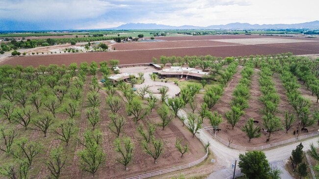
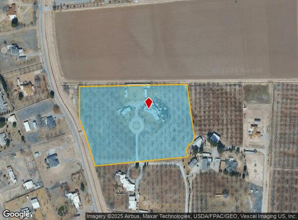
Property Record
7003 Mcnutt Rd, Anthony, NM 88021
NEARBY LISTINGS FOR SALE OR LEASE
Property Detail
7003 Mcnutt Rd
17-14927
Usglo Surveys
Farms
S: 28 T: 27S R: 3E
X
Dona Ana
35013C1725G
New Mexico
2024
9.15 AC
2025
Las Cruces/Alamogordo
001703
Other Market Areas
5,355 SF
Las Cruces, NM
DEMOGRAPHICS near 7003 Mcnutt Rd
1 mile
3 mile
5 mile
2024 Total Population
506
10,657
49,672
2029 Population
518
10,777
50,832
Pop Growth 2024-2029
+ 2.37%
+ 1.13%
+ 2.34%
Average Age
43
38
35
2024 Total Households
183
3,562
15,762
HH Growth 2024-2029
+ 2.73%
+ 1.24%
+ 2.33%
Median Household Inc
$107,422
$57,682
$66,932
Avg Household Size
2.70
2.90
3.10
2024 Avg HH Vehicles
3.00
2.00
2.00
Median Home Value
$531,646
$257,487
$212,003
Median Year Built
1984
1993
2002
Nearby Places
Map Layers
Map Styles
 Street
 Aerial
Transit
 Traffic
 Biking
Places
Listings with unknown addresses are not visible on the map
- Restaurants
- Banks
- Shops
- Fitness
- Groceries
PUBLIC TRANSPORTATION
AIRPORT
El Paso International
Drive
Walk
Distance
El Paso International
46 min
26.9 mi
SALE & LEASE HISTORY
LISTING DATE
SALE/LEASE

Oct 30, 2024
For Sale
Oct 13, 2020
For Sale
Feb 12, 2025
For Sale
Nearby Properties
Address
Land Use
TOTAL SIZE
Lot Size
Zoning
Address
Land Use
TOTAL SIZE
Lot Size
Zoning
142,786 SF
54.77 AC
Address
Land Use
TOTAL SIZE
Lot Size
Zoning
20,672 SF
1 AC
Address
Land Use
TOTAL SIZE
Lot Size
Zoning
58,250 SF
5.13 AC
C4
Address
Land Use
TOTAL SIZE
Lot Size
Zoning
24,118 SF
1.39 AC
Address
Land Use
TOTAL SIZE
Lot Size
Zoning
14,691 SF
10 AC
Address
Land Use
TOTAL SIZE
Lot Size
Zoning
26,215 SF
6.47 AC
Address
Land Use
TOTAL SIZE
Lot Size
Zoning
14,738 SF
1.50 AC
Address
Land Use
TOTAL SIZE
Lot Size
Zoning
9,499 SF
0.67 AC
Address
Land Use
TOTAL SIZE
Lot Size
Zoning
21,607 SF
1.25 AC
Address
Land Use
TOTAL SIZE
Lot Size
Zoning
9,600 SF
1.10 AC
Address
Land Use
TOTAL SIZE
Lot Size
Zoning
38,354 SF
2.05 AC
Address
Land Use
TOTAL SIZE
Lot Size
Zoning
7,742 SF
3.51 AC
Address
Land Use
TOTAL SIZE
Lot Size
Zoning
6,393 SF
0.57 AC
R2C
Address
Land Use
TOTAL SIZE
Lot Size
Zoning
5,646 SF
0.66 AC
R2C
Address
Land Use
TOTAL SIZE
Lot Size
Zoning
10,786 SF
10 AC
C4
Address
Land Use
TOTAL SIZE
Lot Size
Zoning
5,732 SF
0.56 AC
R2C
Address
Land Use
TOTAL SIZE
Lot Size
Zoning
8,926 SF
4.65 AC
Address
Land Use
TOTAL SIZE
Lot Size
Zoning
5,659 SF
0.58 AC
R2C
Address
Land Use
TOTAL SIZE
Lot Size
Zoning
9,280 SF
0.30 AC
Address
Land Use
TOTAL SIZE
Lot Size
Zoning
6,106 SF
0.53 AC
R2C
Address
Land Use
TOTAL SIZE
Lot Size
Zoning
5,239 SF
0.52 AC
R2C
Address
Land Use
TOTAL SIZE
Lot Size
Zoning
16,332 SF
16.72 AC
Address
Land Use
TOTAL SIZE
Lot Size
Zoning
14,862 SF
2.77 AC
Address
Land Use
TOTAL SIZE
Lot Size
Zoning
7,811 SF
4.34 AC
Address
Land Use
TOTAL SIZE
Lot Size
Zoning
23,000 SF
1.04 AC
Address
Land Use
TOTAL SIZE
Lot Size
Zoning
20,604 SF
2 AC
Address
Land Use
TOTAL SIZE
Lot Size
Zoning
10,438 SF
2.42 AC
Address
Land Use
TOTAL SIZE
Lot Size
Zoning
8,336 SF
3.09 AC
Address
Land Use
TOTAL SIZE
Lot Size
Zoning
6,046 SF
1.25 AC
Address
Land Use
TOTAL SIZE
Lot Size
Zoning
7,100 SF
10.54 AC
C4
The World's #1 Commercial Real Estate Marketplace
Connect with us
© 2026 CoStar Group
The information above has been obtained from sources believed reliable. While we do not doubt its accuracy we have not verified it and make no guarantee, warranty or representation about it. It is your responsibility to independently confirm its accuracy and completeness. Any projections, opinions, assumptions, or estimates used are for example only and do not represent the current or future performance of the property. The value of this transaction to you depends on tax and other factors which should be evaluated by your tax, financial, and legal advisors. You and your advisors should conduct a careful, independent investigation of the property to determine to your satisfaction the suitability of the property for your needs.