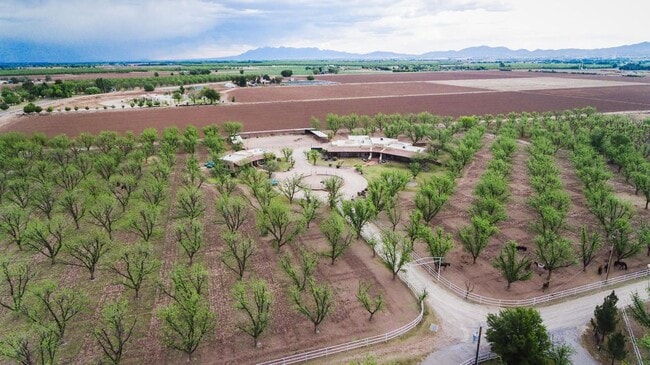
Property Record
7003 Mcnutt Rd, Anthony, NM 88021

Save to a Folder
{{folder.Name}}
{{folder.ListingIds.length}} Properties
{{folder.ListingIds.length}} Property
Create a New Folder
Property Detail
7003 Mcnutt Rd
17-14927
S: 28 T: 27S R: 3E
Farms
Dona Ana
T3
New Mexico
C and X Area of minimal flood hazard, usually depicted on FIRMs as above the 500-year flood level.
9.15 AC
2025
Las Cruces/Alamogordo
2025
Other Market Areas
001703
Las Cruces, NM
6,610 SF
NEARBY LISTINGS FOR SALE OR LEASE
DEMOGRAPHICS near 7003 Mcnutt Rd
1 mile
3 mile
5 mile
2025 Total Population
495
10,981
51,767
2030 Population
499
11,137
52,984
Pop Growth 2025-2030
+ 0.81%
+ 1.42%
+ 2.35%
Average Age
44
38
36
2025 Total Households
179
3,663
16,542
HH Growth 2025-2030
+ 1.12%
+ 1.53%
+ 2.44%
Median Household Inc
$108,984
$65,560
$74,397
Avg Household Size
2.70
3.00
3.00
2025 Avg HH Vehicles
3.00
2.00
2.00
Median Home Value
$609,890
$283,308
$258,439
Median Year Built
1984
1994
2002
Nearby Places
Map Layers
Map Styles
 Street
 Aerial
Layers
 Traffic
 Biking
Places
Listings with unknown addresses are not visible on the map
- Restaurants
- Banks
- Shops
- Fitness
- Groceries
PUBLIC TRANSPORTATION
AIRPORT
El Paso International
Drive
Walk
Distance
El Paso International
46 min
26.9 mi
Freight Ports
Port of San Diego
Drive
Walk
Distance
Port of San Diego
753 min
716.4 mi
SALE & LEASE HISTORY
LISTING DATE
SALE/LEASE

Oct 30, 2024
For Sale
Oct 13, 2020
For Sale
Feb 12, 2025
For Sale
Nearby Properties
Address
Land Use
TOTAL SIZE
Lot Size
Zoning
Address
Land Use
TOTAL SIZE
Lot Size
Zoning
142,786 SF
54.77 AC
Address
Land Use
TOTAL SIZE
Lot Size
Zoning
20,672 SF
1 AC
Address
Land Use
TOTAL SIZE
Lot Size
Zoning
58,250 SF
5.13 AC
C4
Address
Land Use
TOTAL SIZE
Lot Size
Zoning
24,118 SF
1.39 AC
Address
Land Use
TOTAL SIZE
Lot Size
Zoning
14,691 SF
10 AC
Address
Land Use
TOTAL SIZE
Lot Size
Zoning
26,215 SF
6.47 AC
Address
Land Use
TOTAL SIZE
Lot Size
Zoning
21,607 SF
1.25 AC
Address
Land Use
TOTAL SIZE
Lot Size
Zoning
9,600 SF
1.10 AC
Address
Land Use
TOTAL SIZE
Lot Size
Zoning
38,354 SF
2.05 AC
Address
Land Use
TOTAL SIZE
Lot Size
Zoning
10,786 SF
10 AC
C4
Address
Land Use
TOTAL SIZE
Lot Size
Zoning
9,280 SF
0.30 AC
Address
Land Use
TOTAL SIZE
Lot Size
Zoning
16,332 SF
16.72 AC
Address
Land Use
TOTAL SIZE
Lot Size
Zoning
14,862 SF
2.77 AC
Address
Land Use
TOTAL SIZE
Lot Size
Zoning
23,000 SF
1.04 AC
Address
Land Use
TOTAL SIZE
Lot Size
Zoning
20,604 SF
2 AC
Address
Land Use
TOTAL SIZE
Lot Size
Zoning
7,100 SF
10.54 AC
C4
Address
Land Use
TOTAL SIZE
Lot Size
Zoning
16,420 SF
1.82 AC
Address
Land Use
TOTAL SIZE
Lot Size
Zoning
14,240 SF
1.10 AC
Address
Land Use
TOTAL SIZE
Lot Size
Zoning
9,310 SF
4.59 AC
Address
Land Use
TOTAL SIZE
Lot Size
Zoning
7,378 SF
2.31 AC
Address
Land Use
TOTAL SIZE
Lot Size
Zoning
17,850 SF
1.05 AC
Address
Land Use
TOTAL SIZE
Lot Size
Zoning
23,028 SF
2.73 AC
Address
Land Use
TOTAL SIZE
Lot Size
Zoning
14,331 SF
1.07 AC
Address
Land Use
TOTAL SIZE
Lot Size
Zoning
49.32 AC
Address
Land Use
TOTAL SIZE
Lot Size
Zoning
22,078 SF
Address
Land Use
TOTAL SIZE
Lot Size
Zoning
7,136 SF
4.96 AC
Address
Land Use
TOTAL SIZE
Lot Size
Zoning
10,449 SF
5 AC
Address
Land Use
TOTAL SIZE
Lot Size
Zoning
19,950 SF
1.39 AC
Address
Land Use
TOTAL SIZE
Lot Size
Zoning
8,266 SF
Address
Land Use
TOTAL SIZE
Lot Size
Zoning
68.93 AC
The World's #1 Commercial Real Estate Marketplace
Connect with us
© 2026 CoStar Group
The information above has been obtained from sources believed reliable. While we do not doubt its accuracy we have not verified it and make no guarantee, warranty or representation about it. It is your responsibility to independently confirm its accuracy and completeness. Any projections, opinions, assumptions, or estimates used are for example only and do not represent the current or future performance of the property. The value of this transaction to you depends on tax and other factors which should be evaluated by your tax, financial, and legal advisors. You and your advisors should conduct a careful, independent investigation of the property to determine to your satisfaction the suitability of the property for your needs.