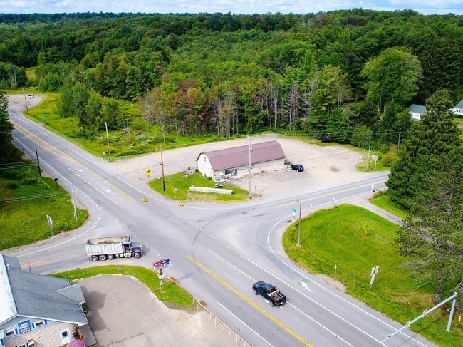
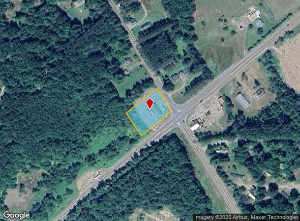
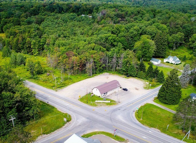
Property Record
7005 Route 219, Lewis Run, PA 16738
NEARBY LISTINGS FOR SALE OR LEASE
-
-
View all Lewis Run listings for sale on LoopNet.com
Property Detail
7005 Route 219
Bradford, PA
Warrant 2256
015-023995
OLD CONTROL:0799-0917
Conveniencestore
Mckean
X
Pennsylvania
42083C0240D
1 AC
2025
Pennsylvania Central Area
2025
Other Market Areas
420900
DEMOGRAPHICS near 7005 Route 219
1 Mile
3 Mile
5 Mile
2024 Total Population
128
431
1,237
2029 Population
123
412
1,183
Pop Growth 2024-2029
(3.91%)
(4.41%)
(4.37%)
Average Age
45
45
44
2024 Total Households
45
150
370
HH Growth 2024-2029
(6.67%)
(5.33%)
(6.76%)
Median Household Inc
$56,666
$56,666
$60,142
Avg Household Size
2.20
2.20
2.20
2024 Avg HH Vehicles
2.00
2.00
2.00
Median Home Value
$97,367
$96,153
$100,568
Median Year Built
1960
1961
1964
Nearby Places
Map Layers
Map Styles
 Street
 Aerial
- Restaurants
- Banks
- Shops
- Fitness
- Groceries
SALE & LEASE HISTORY
LISTING DATE
SALE/LEASE

Sep 28, 2017
For Sale
Nearby Properties
Address
Land Use
TOTAL SIZE
Lot Size
Zoning
Address
Land Use
TOTAL SIZE
Lot Size
Zoning
180.14 AC
Address
Land Use
TOTAL SIZE
Lot Size
Zoning
2,414 AC
Address
Land Use
TOTAL SIZE
Lot Size
Zoning
1,241 AC
Address
Land Use
TOTAL SIZE
Lot Size
Zoning
1,026 AC
Address
Land Use
TOTAL SIZE
Lot Size
Zoning
23.48 AC
Address
Land Use
TOTAL SIZE
Lot Size
Zoning
612 AC
Address
Land Use
TOTAL SIZE
Lot Size
Zoning
Address
Land Use
TOTAL SIZE
Lot Size
Zoning
250 AC
Address
Land Use
TOTAL SIZE
Lot Size
Zoning
39.30 AC
Address
Land Use
TOTAL SIZE
Lot Size
Zoning
36.93 AC
Address
Land Use
TOTAL SIZE
Lot Size
Zoning
Address
Land Use
TOTAL SIZE
Lot Size
Zoning
347.23 AC
Address
Land Use
TOTAL SIZE
Lot Size
Zoning
609.39 AC
Address
Land Use
TOTAL SIZE
Lot Size
Zoning
538.75 AC
Address
Land Use
TOTAL SIZE
Lot Size
Zoning
500.56 AC
Address
Land Use
TOTAL SIZE
Lot Size
Zoning
437.25 AC
Address
Land Use
TOTAL SIZE
Lot Size
Zoning
304.80 AC
Address
Land Use
TOTAL SIZE
Lot Size
Zoning
272 AC
Address
Land Use
TOTAL SIZE
Lot Size
Zoning
270.76 AC
Address
Land Use
TOTAL SIZE
Lot Size
Zoning
13.20 AC
Address
Land Use
TOTAL SIZE
Lot Size
Zoning
106.34 AC
Address
Land Use
TOTAL SIZE
Lot Size
Zoning
0.46 AC
Address
Land Use
TOTAL SIZE
Lot Size
Zoning
116.75 AC
Address
Land Use
TOTAL SIZE
Lot Size
Zoning
0.30 AC
Address
Land Use
TOTAL SIZE
Lot Size
Zoning
242.80 AC
Address
Land Use
TOTAL SIZE
Lot Size
Zoning
27.96 AC
Address
Land Use
TOTAL SIZE
Lot Size
Zoning
172.37 AC
Address
Land Use
TOTAL SIZE
Lot Size
Zoning
816 SF
61.38 AC
Address
Land Use
TOTAL SIZE
Lot Size
Zoning
112.24 AC
The World's #1 Commercial Real Estate Marketplace
Connect with us
© 2025 CoStar Group
The information above has been obtained from sources believed reliable. While we do not doubt its accuracy we have not verified it and make no guarantee, warranty or representation about it. It is your responsibility to independently confirm its accuracy and completeness. Any projections, opinions, assumptions, or estimates used are for example only and do not represent the current or future performance of the property. The value of this transaction to you depends on tax and other factors which should be evaluated by your tax, financial, and legal advisors. You and your advisors should conduct a careful, independent investigation of the property to determine to your satisfaction the suitability of the property for your needs.