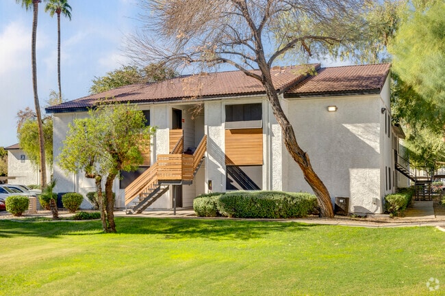
Property Record
7007 W Indian School Rd, Phoenix, AZ 85033

NEARBY LISTINGS FOR SALE OR LEASE
-
-
View all Phoenix listings for sale on LoopNet.com
Property Detail
7007 W Indian School Rd
102-21-023H
E2 NW4 NE4 EX E 318F OF N 660F AND EX N 55F & S 30F & E 30F RDS TOG/WI 30F ABAND R/W LY ADJ AND ELY OF SD PCL P/F 2001-0926568
Apartment
Maricopa
X
Arizona
04013C2180L
13.54 AC
2025
Maryvale
2025
Phoenix
109707
Phoenix-Mesa-Scottsdale, AZ
706,747 SF
DEMOGRAPHICS near 7007 W Indian School Rd
1 Mile
3 Mile
5 Mile
2024 Total Population
31,187
218,807
422,432
2029 Population
33,526
235,271
455,991
Pop Growth 2024-2029
+ 7.50%
+ 7.52%
+ 7.94%
Average Age
31
32
33
2024 Total Households
8,426
60,703
125,325
HH Growth 2024-2029
+ 7.63%
+ 7.63%
+ 8.15%
Median Household Inc
$49,167
$53,585
$53,992
Avg Household Size
3.50
3.40
3.20
2024 Avg HH Vehicles
2.00
2.00
2.00
Median Home Value
$225,468
$230,703
$242,966
Median Year Built
1977
1978
1980
Nearby Places
Map Layers
Map Styles
 Street
 Aerial
- Restaurants
- Banks
- Shops
- Fitness
- Groceries
PUBLIC TRANSPORTATION
AIRPORT
Phoenix Sky Harbor International
DRIVE
WALK
Distance
Phoenix Sky Harbor International
26 min
16.4 mi
Freight Ports
Port of San Diego
DRIVE
WALK
Distance
Port of San Diego
390 min
348.9 mi
Nearby Properties
Address
Land Use
TOTAL SIZE
Lot Size
Zoning
Address
Land Use
TOTAL SIZE
Lot Size
Zoning
569,517 SF
33.38 AC
PUD
Address
Land Use
TOTAL SIZE
Lot Size
Zoning
896,916 SF
25.91 AC
C-C
Address
Land Use
TOTAL SIZE
Lot Size
Zoning
1,267,497 SF
70.43 AC
A1
Address
Land Use
TOTAL SIZE
Lot Size
Zoning
1,100,500 SF
57.61 AC
PUD
Address
Land Use
TOTAL SIZE
Lot Size
Zoning
4,900 SF
12.05 AC
R1-6
Address
Land Use
TOTAL SIZE
Lot Size
Zoning
281,038 SF
7.71 AC
Address
Land Use
TOTAL SIZE
Lot Size
Zoning
285,815 SF
37.17 AC
R-6
Address
Land Use
TOTAL SIZE
Lot Size
Zoning
348,753 SF
19.36 AC
R-6
Address
Land Use
TOTAL SIZE
Lot Size
Zoning
587,843 SF
20.49 AC
PAD
Address
Land Use
TOTAL SIZE
Lot Size
Zoning
659,834 SF
42.04 AC
R-6
Address
Land Use
TOTAL SIZE
Lot Size
Zoning
629,928 SF
41.37 AC
Address
Land Use
TOTAL SIZE
Lot Size
Zoning
351,903 SF
29.13 AC
A1
Address
Land Use
TOTAL SIZE
Lot Size
Zoning
436,817 SF
23.21 AC
I-P
Address
Land Use
TOTAL SIZE
Lot Size
Zoning
316,386 SF
45.04 AC
R16
Address
Land Use
TOTAL SIZE
Lot Size
Zoning
350,874 SF
28.66 AC
C-C
Address
Land Use
TOTAL SIZE
Lot Size
Zoning
660,807 SF
31.44 AC
PAD-14
Address
Land Use
TOTAL SIZE
Lot Size
Zoning
498,064 SF
12.92 AC
C-N
Address
Land Use
TOTAL SIZE
Lot Size
Zoning
1.05 AC
Address
Land Use
TOTAL SIZE
Lot Size
Zoning
587,158 SF
36.23 AC
I-P
Address
Land Use
TOTAL SIZE
Lot Size
Zoning
543,745 SF
31.09 AC
I-1
Address
Land Use
TOTAL SIZE
Lot Size
Zoning
132,597 SF
59.45 AC
C-2
Address
Land Use
TOTAL SIZE
Lot Size
Zoning
92,600 SF
20 AC
C-C
Address
Land Use
TOTAL SIZE
Lot Size
Zoning
367,133 SF
17.88 AC
IND.PK.
Address
Land Use
TOTAL SIZE
Lot Size
Zoning
108,128 SF
18.55 AC
R-43AG
Address
Land Use
TOTAL SIZE
Lot Size
Zoning
95,080 SF
17.39 AC
C2
Address
Land Use
TOTAL SIZE
Lot Size
Zoning
405,621 SF
19.58 AC
M-M
Address
Land Use
TOTAL SIZE
Lot Size
Zoning
95,025 SF
13.59 AC
R1-6
Address
Land Use
TOTAL SIZE
Lot Size
Zoning
404,407 SF
20.94 AC
M-H
Address
Land Use
TOTAL SIZE
Lot Size
Zoning
219,960 SF
12.10 AC
I-P
The World's #1 Commercial Real Estate Marketplace
Connect with us
© 2025 CoStar Group
The information above has been obtained from sources believed reliable. While we do not doubt its accuracy we have not verified it and make no guarantee, warranty or representation about it. It is your responsibility to independently confirm its accuracy and completeness. Any projections, opinions, assumptions, or estimates used are for example only and do not represent the current or future performance of the property. The value of this transaction to you depends on tax and other factors which should be evaluated by your tax, financial, and legal advisors. You and your advisors should conduct a careful, independent investigation of the property to determine to your satisfaction the suitability of the property for your needs.