Property Record
7008 Three Chopt Rd, Richmond, VA 23226
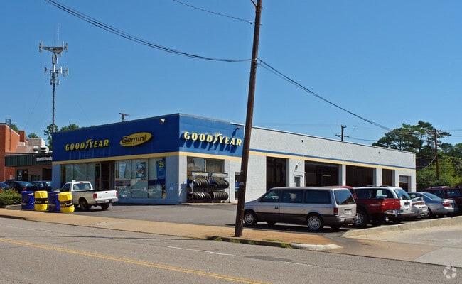

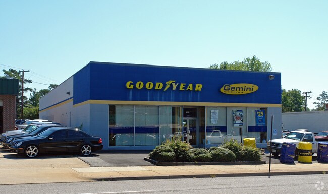
Property Detail
7008 Three Chopt Rd
W021-0124-029
COLLEGE VIEW PTL29 BE 0050.00X0172.80 0000.000
Autorepair
RICHMOND CITY
B-2 COMMUN
Virginia
B and X Area of moderate flood hazard, usually the area between the limits of the 100-year and 500-year floods.
0.19 AC
2025
Willowlawn
2026
Richmond VA
200302
Richmond, VA
6,000 SF
NEARBY LISTINGS FOR SALE OR LEASE
DEMOGRAPHICS near 7008 Three Chopt Rd
1 mile
3 mile
5 mile
2025 Total Population
11,082
79,067
229,329
2030 Population
11,195
80,309
233,478
Pop Growth 2025-2030
+ 1.02%
+ 1.57%
+ 1.81%
Average Age
39
40
41
2025 Total Households
4,714
32,031
101,798
HH Growth 2025-2030
+ 1.19%
+ 1.73%
+ 2.01%
Median Household Inc
$99,477
$92,784
$88,381
Avg Household Size
2.30
2.30
2.10
2025 Avg HH Vehicles
2.00
2.00
2.00
Median Home Value
$471,163
$441,116
$405,587
Median Year Built
1956
1962
1970
Nearby Places
Map Layers
Map Styles
 Street
 Aerial
Layers
 Traffic
 Biking
Places
Listings with unknown addresses are not visible on the map
- Restaurants
- Banks
- Shops
- Fitness
- Groceries
PUBLIC TRANSPORTATION
AIRPORT
Richmond International
Drive
Walk
Distance
Richmond International
28 min
17.4 mi
Nearby Properties
Address
Land Use
TOTAL SIZE
Lot Size
Zoning
Address
Land Use
TOTAL SIZE
Lot Size
Zoning
253,440 SF
48.58 AC
R-3
Address
Land Use
TOTAL SIZE
Lot Size
Zoning
597,042 SF
41.03 AC
R-6C
Address
Land Use
TOTAL SIZE
Lot Size
Zoning
382,570 SF
2.98 AC
UMUC
Address
Land Use
TOTAL SIZE
Lot Size
Zoning
568,334 SF
26.13 AC
MIXED
Address
Land Use
TOTAL SIZE
Lot Size
Zoning
527,410 SF
40.70 AC
A-1
Address
Land Use
TOTAL SIZE
Lot Size
Zoning
321,552 SF
UMUC
Address
Land Use
TOTAL SIZE
Lot Size
Zoning
311,373 SF
2.88 AC
UMUC
Address
Land Use
TOTAL SIZE
Lot Size
Zoning
2.11 AC
M-1
Address
Land Use
TOTAL SIZE
Lot Size
Zoning
2.51 AC
UMUC
Address
Land Use
TOTAL SIZE
Lot Size
Zoning
319,512 SF
20.33 AC
UMU-PD
Address
Land Use
TOTAL SIZE
Lot Size
Zoning
344,965 SF
28.33 AC
MIXED
Address
Land Use
TOTAL SIZE
Lot Size
Zoning
1,404 SF
30.52 AC
R-5
Address
Land Use
TOTAL SIZE
Lot Size
Zoning
224,768 SF
18.08 AC
R-6
Address
Land Use
TOTAL SIZE
Lot Size
Zoning
21,954 SF
4.79 AC
B-3 GENERA
Address
Land Use
TOTAL SIZE
Lot Size
Zoning
246,219 SF
2.39 AC
M-1
Address
Land Use
TOTAL SIZE
Lot Size
Zoning
182,188 SF
21.84 AC
R-5
Address
Land Use
TOTAL SIZE
Lot Size
Zoning
147,352 SF
8.33 AC
R-5 SINGLE
Address
Land Use
TOTAL SIZE
Lot Size
Zoning
320,000 SF
0.61 AC
I INSTITUT
Address
Land Use
TOTAL SIZE
Lot Size
Zoning
500,400 SF
64 AC
R-5
Address
Land Use
TOTAL SIZE
Lot Size
Zoning
395,435 SF
13.26 AC
O-3C
Address
Land Use
TOTAL SIZE
Lot Size
Zoning
231,000 SF
8.57 AC
O-3
Address
Land Use
TOTAL SIZE
Lot Size
Zoning
257,130 SF
33.65 AC
B-3
Address
Land Use
TOTAL SIZE
Lot Size
Zoning
371,568 SF
21.19 AC
R-5
Address
Land Use
TOTAL SIZE
Lot Size
Zoning
60,000 SF
27 AC
R-4 SINGLE
Address
Land Use
TOTAL SIZE
Lot Size
Zoning
272,000 SF
16.66 AC
R-5
Address
Land Use
TOTAL SIZE
Lot Size
Zoning
149,848 SF
0.60 AC
O-3
Address
Land Use
TOTAL SIZE
Lot Size
Zoning
413,600 SF
36.28 AC
R-5
Address
Land Use
TOTAL SIZE
Lot Size
Zoning
301,185 SF
24.65 AC
R-5
Address
Land Use
TOTAL SIZE
Lot Size
Zoning
213,344 SF
16.28 AC
R-5
Address
Land Use
TOTAL SIZE
Lot Size
Zoning
191,826 SF
2.64 AC
I INSTITUT
The World's #1 Commercial Real Estate Marketplace
Connect with us
© 2026 CoStar Group
The information above has been obtained from sources believed reliable. While we do not doubt its accuracy we have not verified it and make no guarantee, warranty or representation about it. It is your responsibility to independently confirm its accuracy and completeness. Any projections, opinions, assumptions, or estimates used are for example only and do not represent the current or future performance of the property. The value of this transaction to you depends on tax and other factors which should be evaluated by your tax, financial, and legal advisors. You and your advisors should conduct a careful, independent investigation of the property to determine to your satisfaction the suitability of the property for your needs.