Property Record
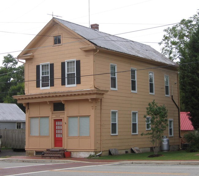
7009 Main St, Queenstown, MD 21658

NEARBY LISTINGS FOR SALE OR LEASE
Property Detail
7009 Main St
05-015383
Lands Of Kristen Hagerstrom
Multifamilydwelling
LOT - 9,460 SQ FT N/MAIN ST QUEENSTOWN
X
Queen Annes
24035C0331D
Maryland
2025
0.22 AC
2025
Queen Anne's County
810600
Baltimore
1,920 SF
Baltimore-Columbia-Towson, MD
DEMOGRAPHICS near 7009 Main St
1 Mile
3 Mile
5 Mile
2024 Total Population
829
2,892
8,299
2029 Population
903
3,141
9,035
Pop Growth 2024-2029
+ 8.93%
+ 8.61%
+ 8.87%
Average Age
42
42
43
2024 Total Households
327
1,124
3,233
HH Growth 2024-2029
+ 8.87%
+ 8.63%
+ 8.85%
Median Household Inc
$84,191
$90,308
$105,517
Avg Household Size
2.50
2.50
2.50
2024 Avg HH Vehicles
2.00
2.00
2.00
Median Home Value
$348,255
$390,732
$438,809
Median Year Built
1977
1982
1986
Nearby Places
Map Layers
Map Styles
 Street
 Aerial
- Restaurants
- Banks
- Shops
- Fitness
- Groceries
Nearby Properties
Address
Land Use
TOTAL SIZE
Lot Size
Zoning
Address
Land Use
TOTAL SIZE
Lot Size
Zoning
12,950 SF
8.72 AC
SC
Address
Land Use
TOTAL SIZE
Lot Size
Zoning
69,030 SF
15 AC
SC
Address
Land Use
TOTAL SIZE
Lot Size
Zoning
9,330 SF
710.48 AC
CS
Address
Land Use
TOTAL SIZE
Lot Size
Zoning
50,866 SF
4.37 AC
GGMS
Address
Land Use
TOTAL SIZE
Lot Size
Zoning
60,756 SF
3.57 AC
SE
Address
Land Use
TOTAL SIZE
Lot Size
Zoning
53,927 SF
18.74 AC
SR
Address
Land Use
TOTAL SIZE
Lot Size
Zoning
16,442 SF
3.77 AC
SE
Address
Land Use
TOTAL SIZE
Lot Size
Zoning
3,716 SF
19.15 AC
SI
Address
Land Use
TOTAL SIZE
Lot Size
Zoning
9,600 SF
257.91 AC
AG
Address
Land Use
TOTAL SIZE
Lot Size
Zoning
4,800 SF
5 AC
UC
Address
Land Use
TOTAL SIZE
Lot Size
Zoning
28.02 AC
SC
Address
Land Use
TOTAL SIZE
Lot Size
Zoning
6,400 SF
144.14 AC
SI
Address
Land Use
TOTAL SIZE
Lot Size
Zoning
44,390 SF
0.85 AC
GGMS
Address
Land Use
TOTAL SIZE
Lot Size
Zoning
4,682 SF
2.60 AC
UC
Address
Land Use
TOTAL SIZE
Lot Size
Zoning
9.65 AC
SI
Address
Land Use
TOTAL SIZE
Lot Size
Zoning
21,420 SF
6.17 AC
NC20T
Address
Land Use
TOTAL SIZE
Lot Size
Zoning
12,016 SF
4.36 AC
GGMS
Address
Land Use
TOTAL SIZE
Lot Size
Zoning
11,242 SF
3.13 AC
GGMS
Address
Land Use
TOTAL SIZE
Lot Size
Zoning
120 SF
3.44 AC
Address
Land Use
TOTAL SIZE
Lot Size
Zoning
25,200 SF
1.66 AC
UC
Address
Land Use
TOTAL SIZE
Lot Size
Zoning
7,048 SF
17.76 AC
SR
Address
Land Use
TOTAL SIZE
Lot Size
Zoning
1,260 SF
2.43 AC
SC
Address
Land Use
TOTAL SIZE
Lot Size
Zoning
2,460 SF
1 AC
UC
Address
Land Use
TOTAL SIZE
Lot Size
Zoning
5.57 AC
SI
Address
Land Use
TOTAL SIZE
Lot Size
Zoning
189.88 AC
CS
Address
Land Use
TOTAL SIZE
Lot Size
Zoning
6.87 AC
SE
Address
Land Use
TOTAL SIZE
Lot Size
Zoning
4,668 SF
0.59 AC
SR
Address
Land Use
TOTAL SIZE
Lot Size
Zoning
7,650 SF
10.28 AC
UC
Address
Land Use
TOTAL SIZE
Lot Size
Zoning
11,360 SF
3.60 AC
NC-1T
Address
Land Use
TOTAL SIZE
Lot Size
Zoning
12,025 SF
1.15 AC
TC
The World's #1 Commercial Real Estate Marketplace
Connect with us
© 2025 CoStar Group
The information above has been obtained from sources believed reliable. While we do not doubt its accuracy we have not verified it and make no guarantee, warranty or representation about it. It is your responsibility to independently confirm its accuracy and completeness. Any projections, opinions, assumptions, or estimates used are for example only and do not represent the current or future performance of the property. The value of this transaction to you depends on tax and other factors which should be evaluated by your tax, financial, and legal advisors. You and your advisors should conduct a careful, independent investigation of the property to determine to your satisfaction the suitability of the property for your needs.