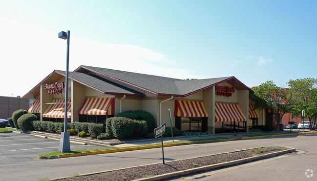
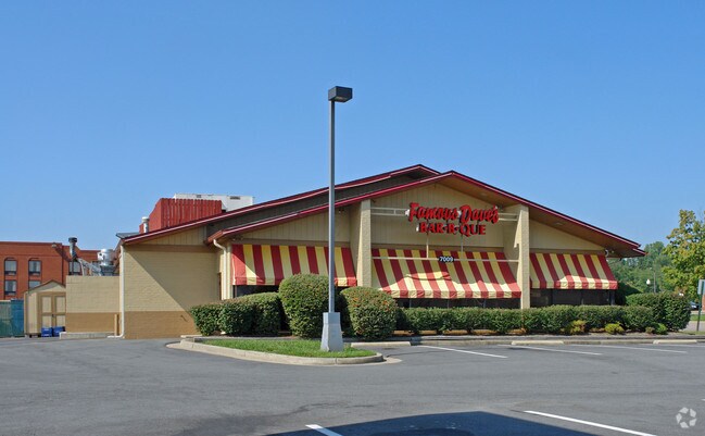
Property Record
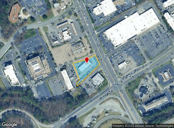
7009 W Broad St, Henrico, VA 23294
NEARBY LISTINGS FOR SALE OR LEASE
Property Detail
7009 W Broad St
766-746-9974
00810A0000 0068A; W BROAD ST AC 1.059 93 B2 42
Storebuilding
Henrico
X
Virginia
5101290010E
1.06 AC
2025
Broad St Corridor
2025
Richmond VA
200305
Richmond, VA
8,442 SF
DEMOGRAPHICS near 7009 W Broad St
1 Mile
3 Mile
5 Mile
2024 Total Population
11,858
91,488
225,855
2029 Population
11,922
91,655
226,935
Pop Growth 2024-2029
+ 0.54%
+ 0.18%
+ 0.48%
Average Age
38
39
41
2024 Total Households
5,045
38,337
97,749
HH Growth 2024-2029
+ 0.61%
+ 0.19%
+ 0.59%
Median Household Inc
$57,645
$75,388
$80,464
Avg Household Size
2.20
2.20
2.20
2024 Avg HH Vehicles
2.00
2.00
2.00
Median Home Value
$259,754
$290,867
$336,705
Median Year Built
1976
1969
1971
Nearby Places
Map Layers
Map Styles
 Street
 Aerial
- Restaurants
- Banks
- Shops
- Fitness
- Groceries
PUBLIC TRANSPORTATION
COMMUTER RAIL
DRIVE
WALK
Distance
4 min
1.8 mi
DRIVE
WALK
Distance
13 min
8.5 mi
AIRPORT
Richmond International
DRIVE
WALK
Distance
Richmond International
26 min
16.4 mi
SALE & LEASE HISTORY
LISTING DATE
SALE/LEASE

Sep 25, 2016
For Lease
Nearby Properties
Address
Land Use
TOTAL SIZE
Lot Size
Zoning
Address
Land Use
TOTAL SIZE
Lot Size
Zoning
172,000 SF
48.58 AC
R-3
Address
Land Use
TOTAL SIZE
Lot Size
Zoning
585,792 SF
38.94 AC
R-5
Address
Land Use
TOTAL SIZE
Lot Size
Zoning
597,042 SF
41.03 AC
R-6C
Address
Land Use
TOTAL SIZE
Lot Size
Zoning
382,570 SF
2.98 AC
UMUC
Address
Land Use
TOTAL SIZE
Lot Size
Zoning
568,334 SF
26.13 AC
MIXE
Address
Land Use
TOTAL SIZE
Lot Size
Zoning
173,400 SF
42 AC
MIXE
Address
Land Use
TOTAL SIZE
Lot Size
Zoning
527,410 SF
40.70 AC
A-1
Address
Land Use
TOTAL SIZE
Lot Size
Zoning
321,552 SF
UMUC
Address
Land Use
TOTAL SIZE
Lot Size
Zoning
2.11 AC
M-1
Address
Land Use
TOTAL SIZE
Lot Size
Zoning
319,512 SF
20.33 AC
UMU
Address
Land Use
TOTAL SIZE
Lot Size
Zoning
309,500 SF
29.78 AC
MIXE
Address
Land Use
TOTAL SIZE
Lot Size
Zoning
344,965 SF
28.33 AC
MIXE
Address
Land Use
TOTAL SIZE
Lot Size
Zoning
271,060 SF
18.31 AC
R-6
Address
Land Use
TOTAL SIZE
Lot Size
Zoning
2.51 AC
UMUC
Address
Land Use
TOTAL SIZE
Lot Size
Zoning
250,146 SF
20.41 AC
R-5
Address
Land Use
TOTAL SIZE
Lot Size
Zoning
1,404 SF
30.52 AC
R-5
Address
Land Use
TOTAL SIZE
Lot Size
Zoning
395,435 SF
13.26 AC
O-3C
Address
Land Use
TOTAL SIZE
Lot Size
Zoning
224,768 SF
18.08 AC
R-6
Address
Land Use
TOTAL SIZE
Lot Size
Zoning
296,784 SF
23.11 AC
R-5
Address
Land Use
TOTAL SIZE
Lot Size
Zoning
182,188 SF
21.84 AC
R-5
Address
Land Use
TOTAL SIZE
Lot Size
Zoning
257,130 SF
33.65 AC
B-3
Address
Land Use
TOTAL SIZE
Lot Size
Zoning
320,000 SF
0.61 AC
I INSTITUT
Address
Land Use
TOTAL SIZE
Lot Size
Zoning
500,400 SF
31.15 AC
R-5
Address
Land Use
TOTAL SIZE
Lot Size
Zoning
232,368 SF
26.11 AC
R-5
Address
Land Use
TOTAL SIZE
Lot Size
Zoning
174,500 SF
8.57 AC
O-3
Address
Land Use
TOTAL SIZE
Lot Size
Zoning
227,905 SF
58.94 AC
R-3
Address
Land Use
TOTAL SIZE
Lot Size
Zoning
60,000 SF
27 AC
R-4 SINGLE
Address
Land Use
TOTAL SIZE
Lot Size
Zoning
371,568 SF
21.19 AC
R-5
Address
Land Use
TOTAL SIZE
Lot Size
Zoning
158,900 SF
18.52 AC
R-5
Address
Land Use
TOTAL SIZE
Lot Size
Zoning
167,576 SF
14.29 AC
R-5
The World's #1 Commercial Real Estate Marketplace
Connect with us
© 2025 CoStar Group
The information above has been obtained from sources believed reliable. While we do not doubt its accuracy we have not verified it and make no guarantee, warranty or representation about it. It is your responsibility to independently confirm its accuracy and completeness. Any projections, opinions, assumptions, or estimates used are for example only and do not represent the current or future performance of the property. The value of this transaction to you depends on tax and other factors which should be evaluated by your tax, financial, and legal advisors. You and your advisors should conduct a careful, independent investigation of the property to determine to your satisfaction the suitability of the property for your needs.