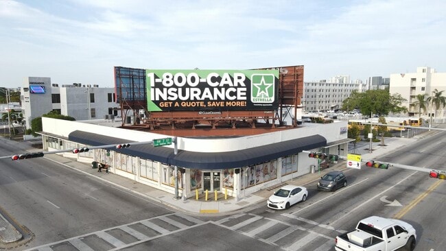
Property Record
701 Nw 27Th Ave, Miami, FL 33125

NEARBY LISTINGS FOR SALE OR LEASE
Property Detail
701 Nw 27Th Ave
Miami-Miami Beach-Kendall, FL
The Hub
01-3134-035-0170
THE HUB PB 9-124 LOTS 1 THRU 5 LESS PORT OF LOT 1 BEG 40.16FTN & 50FTE OF SW COR OF SEC TH S 47 DEG E 7.06FT S 87 DEG W 4.92FT WLY AD .08FT N 2 DEG W 5FT TO POB BLK 2 & LOTS 50 & 51 LESS PORT LYG IN R/W BLK 2 LOT SIZE 18081 SQ FT
Storemultistory
Miami/Dade
X
Florida
12086C0313L
1-5,1
2024
0.42 AC
2025
Miami
005103
South Florida
9,446 SF
DEMOGRAPHICS near 701 Nw 27Th Ave
1 Mile
3 Mile
5 Mile
2024 Total Population
37,210
296,562
582,933
2029 Population
35,614
289,999
573,793
Pop Growth 2024-2029
(4.29%)
(2.21%)
(1.57%)
Average Age
43
42
41
2024 Total Households
13,350
118,389
236,609
HH Growth 2024-2029
(4.65%)
(2.33%)
(1.59%)
Median Household Inc
$36,252
$43,504
$52,861
Avg Household Size
2.60
2.40
2.30
2024 Avg HH Vehicles
1.00
1.00
1.00
Median Home Value
$340,019
$395,275
$432,467
Median Year Built
1962
1971
1975
Nearby Places
Map Layers
Map Styles
 Street
 Aerial
- Restaurants
- Banks
- Shops
- Fitness
- Groceries
PUBLIC TRANSPORTATION
COMMUTER RAIL
Miami Airport (Tri-County Commuter - South Florida Regional Transportation Authority (Tri-Rail))
DRIVE
WALK
Distance
Miami Airport (Tri-County Commuter - South Florida Regional Transportation Authority (Tri-Rail))
5 min
2.2 mi
Civic Center (Metrorail Green Line - Miami-Dade Transit (Metrorail/Metromover))
DRIVE
WALK
Distance
Civic Center (Metrorail Green Line - Miami-Dade Transit (Metrorail/Metromover))
6 min
2.4 mi
AIRPORT
Miami International
DRIVE
WALK
Distance
Miami International
17 min
8.2 mi
Fort Lauderdale/Hollywood International
DRIVE
WALK
Distance
Fort Lauderdale/Hollywood International
35 min
24.5 mi
SALE & LEASE HISTORY
LISTING DATE
SALE/LEASE

Nov 10, 2016
For Lease
Mar 26, 2021
For Lease
Mar 25, 2025
For Lease
Jun 12, 2018
For Lease
Nearby Properties
Address
Land Use
TOTAL SIZE
Lot Size
Zoning
Address
Land Use
TOTAL SIZE
Lot Size
Zoning
955,966 SF
38.91 AC
9600
Address
Land Use
TOTAL SIZE
Lot Size
Zoning
928,000 SF
14.30 AC
8000
Address
Land Use
TOTAL SIZE
Lot Size
Zoning
16.13 AC
6100
Address
Land Use
TOTAL SIZE
Lot Size
Zoning
2,789,683 SF
33.23 AC
7300
Address
Land Use
TOTAL SIZE
Lot Size
Zoning
2,403,353 SF
7.37 AC
6100
Address
Land Use
TOTAL SIZE
Lot Size
Zoning
1,544,491 SF
0.97 AC
6401
Address
Land Use
TOTAL SIZE
Lot Size
Zoning
416,675 SF
6.48 AC
6401
Address
Land Use
TOTAL SIZE
Lot Size
Zoning
256,089 SF
20.35 AC
7600
Address
Land Use
TOTAL SIZE
Lot Size
Zoning
585,775 SF
1.86 AC
6101
Address
Land Use
TOTAL SIZE
Lot Size
Zoning
903,993 SF
0.60 AC
6412
Address
Land Use
TOTAL SIZE
Lot Size
Zoning
872,245 SF
0.56 AC
6401
Address
Land Use
TOTAL SIZE
Lot Size
Zoning
727,757 SF
0.64 AC
6408
Address
Land Use
TOTAL SIZE
Lot Size
Zoning
2 AC
8000
Address
Land Use
TOTAL SIZE
Lot Size
Zoning
1,101,032 SF
5.18 AC
8000
Address
Land Use
TOTAL SIZE
Lot Size
Zoning
1,262,330 SF
1.39 AC
6402
Address
Land Use
TOTAL SIZE
Lot Size
Zoning
845,870 SF
1.30 AC
6412
Address
Land Use
TOTAL SIZE
Lot Size
Zoning
570,694 SF
1.37 AC
4604
Address
Land Use
TOTAL SIZE
Lot Size
Zoning
655,148 SF
0.30 AC
6401
Address
Land Use
TOTAL SIZE
Lot Size
Zoning
990,766 SF
1.16 AC
6420
Address
Land Use
TOTAL SIZE
Lot Size
Zoning
615,867 SF
1.87 AC
6402
Address
Land Use
TOTAL SIZE
Lot Size
Zoning
413,538 SF
3.07 AC
6408
Address
Land Use
TOTAL SIZE
Lot Size
Zoning
996,100 SF
3.58 AC
9600
Address
Land Use
TOTAL SIZE
Lot Size
Zoning
787,433 SF
2.15 AC
6402
Address
Land Use
TOTAL SIZE
Lot Size
Zoning
627,685 SF
2.06 AC
6100
Address
Land Use
TOTAL SIZE
Lot Size
Zoning
612,782 SF
2.41 AC
6402
Address
Land Use
TOTAL SIZE
Lot Size
Zoning
91,119 SF
50.72 AC
8000
Address
Land Use
TOTAL SIZE
Lot Size
Zoning
602,884 SF
0.32 AC
6412
Address
Land Use
TOTAL SIZE
Lot Size
Zoning
328,554 SF
668.26 AC
8900
Address
Land Use
TOTAL SIZE
Lot Size
Zoning
428,154 SF
1.39 AC
6101
Address
Land Use
TOTAL SIZE
Lot Size
Zoning
375,762 SF
3.39 AC
8000
The World's #1 Commercial Real Estate Marketplace
Connect with us
© 2025 CoStar Group
The information above has been obtained from sources believed reliable. While we do not doubt its accuracy we have not verified it and make no guarantee, warranty or representation about it. It is your responsibility to independently confirm its accuracy and completeness. Any projections, opinions, assumptions, or estimates used are for example only and do not represent the current or future performance of the property. The value of this transaction to you depends on tax and other factors which should be evaluated by your tax, financial, and legal advisors. You and your advisors should conduct a careful, independent investigation of the property to determine to your satisfaction the suitability of the property for your needs.