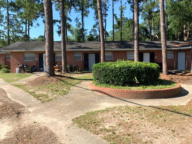
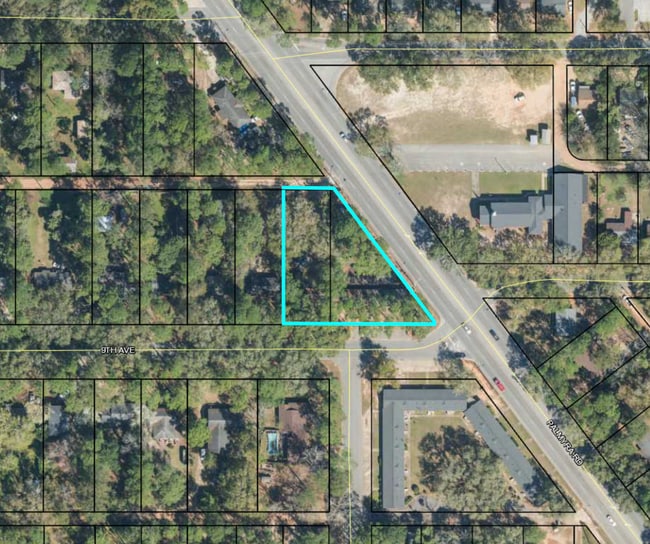
Property Record
701 9Th Ave, Albany, GA 31701

NEARBY LISTINGS FOR SALE OR LEASE
-
-
View all Albany listings for sale on LoopNet.com
Property Detail
701 9Th Ave
Albany, GA
Palmyra Rd Downtown
000FF-00002-009
BLK 33 LOT 1 RAWSON CIRCLE
Apartment
Dougherty
X
Georgia
13095C0106E
1
2024
0.44 AC
2024
Albany/Southwest
000700
Other Market Areas
3,426 SF
DEMOGRAPHICS near 701 9Th Ave
1 Mile
3 Mile
5 Mile
2024 Total Population
5,288
38,302
74,379
2029 Population
5,079
36,982
72,300
Pop Growth 2024-2029
(3.95%)
(3.45%)
(2.80%)
Average Age
39
38
38
2024 Total Households
2,389
16,489
30,589
HH Growth 2024-2029
(3.81%)
(3.54%)
(3.03%)
Median Household Inc
$38,465
$42,789
$44,119
Avg Household Size
2.10
2.20
2.30
2024 Avg HH Vehicles
1.00
1.00
2.00
Median Home Value
$97,040
$109,582
$129,977
Median Year Built
1956
1970
1976
Nearby Places
Map Layers
Map Styles
 Street
 Aerial
- Restaurants
- Banks
- Shops
- Fitness
- Groceries
PUBLIC TRANSPORTATION
AIRPORT
Southwest Georgia Regional
DRIVE
WALK
Distance
Southwest Georgia Regional
14 min
6.1 mi
Freight Ports
Port of Panama City
DRIVE
WALK
Distance
Port of Panama City
234 min
160.1 mi
SALE & LEASE HISTORY
LISTING DATE
SALE/LEASE

May 08, 2023
For Sale
May 05, 2021
For Sale
Nearby Properties
Address
Land Use
TOTAL SIZE
Lot Size
Zoning
Address
Land Use
TOTAL SIZE
Lot Size
Zoning
Address
Land Use
TOTAL SIZE
Lot Size
Zoning
58.86 AC
C3
Address
Land Use
TOTAL SIZE
Lot Size
Zoning
51,008 SF
19.48 AC
C5
Address
Land Use
TOTAL SIZE
Lot Size
Zoning
274,484 SF
16.31 AC
C5
Address
Land Use
TOTAL SIZE
Lot Size
Zoning
1.77 AC
C2
Address
Land Use
TOTAL SIZE
Lot Size
Zoning
15.20 AC
C2
Address
Land Use
TOTAL SIZE
Lot Size
Zoning
2.53 AC
C2
Address
Land Use
TOTAL SIZE
Lot Size
Zoning
1.75 AC
C2
Address
Land Use
TOTAL SIZE
Lot Size
Zoning
0.83 AC
C2
Address
Land Use
TOTAL SIZE
Lot Size
Zoning
1,752 SF
13.25 AC
RESIDENTIA
Address
Land Use
TOTAL SIZE
Lot Size
Zoning
131,385 SF
21.89 AC
C3
Address
Land Use
TOTAL SIZE
Lot Size
Zoning
77,688 SF
2.93 AC
C3
Address
Land Use
TOTAL SIZE
Lot Size
Zoning
70,596 SF
2.38 AC
C2
Address
Land Use
TOTAL SIZE
Lot Size
Zoning
232,840 SF
49.88 AC
M1
Address
Land Use
TOTAL SIZE
Lot Size
Zoning
0.54 AC
C2
Address
Land Use
TOTAL SIZE
Lot Size
Zoning
107,500 SF
11.27 AC
C2
Address
Land Use
TOTAL SIZE
Lot Size
Zoning
9,676 SF
10.73 AC
R6
Address
Land Use
TOTAL SIZE
Lot Size
Zoning
129,973 SF
21.89 AC
C3
Address
Land Use
TOTAL SIZE
Lot Size
Zoning
21,760 SF
10.76 AC
R6
Address
Land Use
TOTAL SIZE
Lot Size
Zoning
21,144 SF
11.79 AC
R6
Address
Land Use
TOTAL SIZE
Lot Size
Zoning
9,216 SF
14.31 AC
COMMERCIAL
Address
Land Use
TOTAL SIZE
Lot Size
Zoning
5,768 SF
16.40 AC
R6
Address
Land Use
TOTAL SIZE
Lot Size
Zoning
19,104 SF
10.81 AC
R6
Address
Land Use
TOTAL SIZE
Lot Size
Zoning
8 AC
M1
Address
Land Use
TOTAL SIZE
Lot Size
Zoning
73,610 SF
7.34 AC
C2
Address
Land Use
TOTAL SIZE
Lot Size
Zoning
0.52 AC
C2
Address
Land Use
TOTAL SIZE
Lot Size
Zoning
23,800 SF
4.79 AC
C2
Address
Land Use
TOTAL SIZE
Lot Size
Zoning
98,560 SF
19.64 AC
R6
Address
Land Use
TOTAL SIZE
Lot Size
Zoning
100,392 SF
11.25 AC
C3
Address
Land Use
TOTAL SIZE
Lot Size
Zoning
82,944 SF
8.10 AC
R6
The World's #1 Commercial Real Estate Marketplace
Connect with us
© 2026 CoStar Group
The information above has been obtained from sources believed reliable. While we do not doubt its accuracy we have not verified it and make no guarantee, warranty or representation about it. It is your responsibility to independently confirm its accuracy and completeness. Any projections, opinions, assumptions, or estimates used are for example only and do not represent the current or future performance of the property. The value of this transaction to you depends on tax and other factors which should be evaluated by your tax, financial, and legal advisors. You and your advisors should conduct a careful, independent investigation of the property to determine to your satisfaction the suitability of the property for your needs.