Property Record
701 Algroup Way, Chester, VA 23836

NEARBY LISTINGS FOR SALE OR LEASE
Property Detail
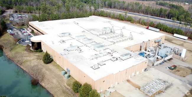
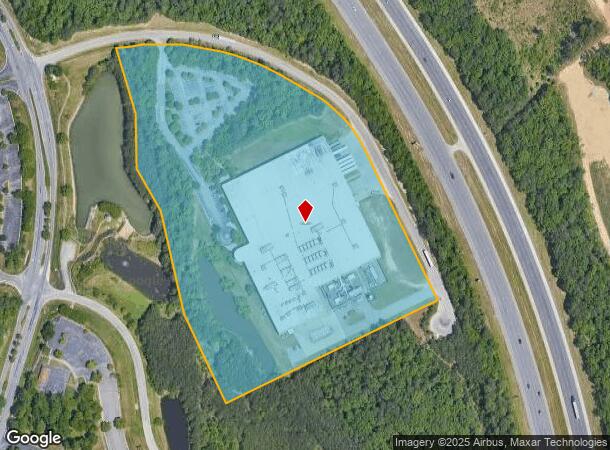
701 Algroup Way
820-65-47-41-000-000
Situated Off Kingston Avenue
Heavymanufacturing
SITUATED OFF KINGSTON AVENUE
X
Chesterfield
51041C0352E
Virginia
0
15.17 AC
2025
I-95 S/I-295 S/Rt 10
100403
Richmond VA
203,544 SF
Richmond, VA
DEMOGRAPHICS near 701 Algroup Way
1 Mile
3 Mile
5 Mile
2024 Total Population
1,960
16,721
47,635
2029 Population
2,141
18,472
50,392
Pop Growth 2024-2029
+ 9.23%
+ 10.47%
+ 5.79%
Average Age
41
40
39
2024 Total Households
754
5,998
16,590
HH Growth 2024-2029
+ 9.15%
+ 10.42%
+ 6.00%
Median Household Inc
$94,493
$96,268
$71,123
Avg Household Size
2.60
2.70
2.60
2024 Avg HH Vehicles
2.00
2.00
2.00
Median Home Value
$337,353
$327,287
$246,621
Median Year Built
1996
1995
1985
Nearby Places
Map Layers
Map Styles
 Street
 Aerial
- Restaurants
- Banks
- Shops
- Fitness
- Groceries
PUBLIC TRANSPORTATION
AIRPORT
Richmond International
DRIVE
WALK
Distance
Richmond International
28 min
17.0 mi
Freight Ports
Virginia Port Authority - Richmond
DRIVE
WALK
Distance
Virginia Port Authority - Richmond
24 min
14.1 mi
Nearby Properties
Address
Land Use
TOTAL SIZE
Lot Size
Zoning
Address
Land Use
TOTAL SIZE
Lot Size
Zoning
99.30 AC
I2 - GEN I
Address
Land Use
TOTAL SIZE
Lot Size
Zoning
252,000 SF
118.66 AC
I3 - HVY I
Address
Land Use
TOTAL SIZE
Lot Size
Zoning
557,533 SF
48.60 AC
I2 - GEN I
Address
Land Use
TOTAL SIZE
Lot Size
Zoning
41,930 SF
23.04 AC
C5 - GEN B
Address
Land Use
TOTAL SIZE
Lot Size
Zoning
88,847 SF
93.02 AC
A - AGRICU
Address
Land Use
TOTAL SIZE
Lot Size
Zoning
49,595 SF
28.14 AC
I2 - GEN I
Address
Land Use
TOTAL SIZE
Lot Size
Zoning
352,800 SF
54.30 AC
I2 - GEN I
Address
Land Use
TOTAL SIZE
Lot Size
Zoning
81,138 SF
27.31 AC
C2 - NBHD
Address
Land Use
TOTAL SIZE
Lot Size
Zoning
100 SF
14.70 AC
C5 - GEN B
Address
Land Use
TOTAL SIZE
Lot Size
Zoning
404,200 SF
62.22 AC
I2 - GEN I
Address
Land Use
TOTAL SIZE
Lot Size
Zoning
242,042 SF
10.15 AC
I2 - GEN I
Address
Land Use
TOTAL SIZE
Lot Size
Zoning
91,105 SF
10.90 AC
C3 - COMMU
Address
Land Use
TOTAL SIZE
Lot Size
Zoning
340.76 AC
I2 - GEN I
Address
Land Use
TOTAL SIZE
Lot Size
Zoning
490,345 SF
101.57 AC
I2 - GEN I
Address
Land Use
TOTAL SIZE
Lot Size
Zoning
47.44 AC
MH1 - MOBI
Address
Land Use
TOTAL SIZE
Lot Size
Zoning
219 SF
74.95 AC
I3 - HVY I
Address
Land Use
TOTAL SIZE
Lot Size
Zoning
158,400 SF
9.96 AC
I1 - LT IN
Address
Land Use
TOTAL SIZE
Lot Size
Zoning
228,108 SF
19.32 AC
I1 - LT IN
Address
Land Use
TOTAL SIZE
Lot Size
Zoning
95,824 SF
2.29 AC
C3 - COMMU
Address
Land Use
TOTAL SIZE
Lot Size
Zoning
35,173 SF
19.30 AC
C3 - COMMU
Address
Land Use
TOTAL SIZE
Lot Size
Zoning
120 SF
100.80 AC
I3 - HVY I
Address
Land Use
TOTAL SIZE
Lot Size
Zoning
90,300 SF
7.44 AC
I2 - GEN I
Address
Land Use
TOTAL SIZE
Lot Size
Zoning
170,800 SF
13.74 AC
I1 - LT IN
Address
Land Use
TOTAL SIZE
Lot Size
Zoning
73,072 SF
3.37 AC
R15 - SING
Address
Land Use
TOTAL SIZE
Lot Size
Zoning
296.90 AC
I3 - HVY I
Address
Land Use
TOTAL SIZE
Lot Size
Zoning
12,591 SF
4.69 AC
C2 - NBHD
Address
Land Use
TOTAL SIZE
Lot Size
Zoning
124.99 AC
I2 - GEN I
Address
Land Use
TOTAL SIZE
Lot Size
Zoning
136,644 SF
13.24 AC
I3 - HVY I
Address
Land Use
TOTAL SIZE
Lot Size
Zoning
144,000 SF
8.31 AC
I1 - LT IN
The World's #1 Commercial Real Estate Marketplace
Connect with us
© 2025 CoStar Group
The information above has been obtained from sources believed reliable. While we do not doubt its accuracy we have not verified it and make no guarantee, warranty or representation about it. It is your responsibility to independently confirm its accuracy and completeness. Any projections, opinions, assumptions, or estimates used are for example only and do not represent the current or future performance of the property. The value of this transaction to you depends on tax and other factors which should be evaluated by your tax, financial, and legal advisors. You and your advisors should conduct a careful, independent investigation of the property to determine to your satisfaction the suitability of the property for your needs.