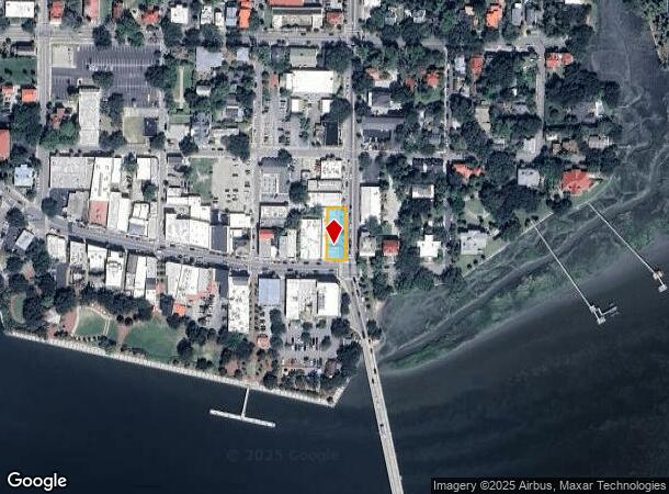
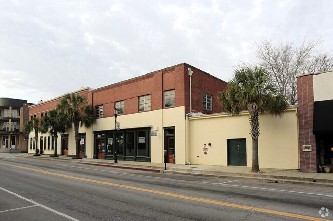
Property Record
701 Bay St, Beaufort, SC 29902

NEARBY LISTINGS FOR SALE OR LEASE
-
-
-
-
-
-
No Photo
-
View all Beaufort listings for lease on LoopNet.com
Property Detail
701 Bay St
Hilton Head Island-Bluffton-Port Royal, SC
Bft Ctrl Bus. Dist. Hist. Comm
R120-004-000-0947-0000
LT D BLK 49 CITY OF BEAUFORT *FORDHAM ANGUS DUNCAN JR (CON'T) 3% INT. 03850088
Storebuilding
Beaufort
2025
South Carolina
2024
0.19 AC
000700
Other Market Areas
15,989 SF
DEMOGRAPHICS near 701 Bay St
1 Mile
3 Mile
5 Mile
2024 Total Population
1,846
18,556
37,100
2029 Population
2,077
20,460
40,754
Pop Growth 2024-2029
+ 12.51%
+ 10.26%
+ 9.85%
Average Age
46
42
40
2024 Total Households
881
7,856
14,471
HH Growth 2024-2029
+ 12.03%
+ 9.81%
+ 9.87%
Median Household Inc
$50,081
$61,179
$62,350
Avg Household Size
2.00
2.30
2.40
2024 Avg HH Vehicles
2.00
2.00
2.00
Median Home Value
$378,676
$333,215
$312,905
Median Year Built
1955
1988
1990
Nearby Places
Map Layers
Map Styles
 Street
 Aerial
- Restaurants
- Banks
- Shops
- Fitness
- Groceries
PUBLIC TRANSPORTATION
AIRPORT
Hilton Head
DRIVE
WALK
Distance
Hilton Head
54 min
39.1 mi
Savannah/Hilton Head International
DRIVE
WALK
Distance
Savannah/Hilton Head International
65 min
47.8 mi
Freight Ports
Georgia Ports - Savannah
DRIVE
WALK
Distance
Georgia Ports - Savannah
63 min
48.5 mi
SALE & LEASE HISTORY
LISTING DATE
SALE/LEASE

Mar 15, 2017
For Lease
Nearby Properties
Address
Land Use
TOTAL SIZE
Lot Size
Zoning
Address
Land Use
TOTAL SIZE
Lot Size
Zoning
245,864 SF
19.36 AC
6601
Address
Land Use
TOTAL SIZE
Lot Size
Zoning
24,000 SF
4.45 AC
6601
Address
Land Use
TOTAL SIZE
Lot Size
Zoning
19,232 SF
16.27 AC
6612
Address
Land Use
TOTAL SIZE
Lot Size
Zoning
144,673 SF
19.30 AC
4201
Address
Land Use
TOTAL SIZE
Lot Size
Zoning
101,304 SF
6.47 AC
6611
Address
Land Use
TOTAL SIZE
Lot Size
Zoning
39,296 SF
2.05 AC
6611
Address
Land Use
TOTAL SIZE
Lot Size
Zoning
34,200 SF
4.18 AC
6601
Address
Land Use
TOTAL SIZE
Lot Size
Zoning
144,226 SF
41.30 AC
6611
Address
Land Use
TOTAL SIZE
Lot Size
Zoning
116,067 SF
27 AC
6611
Address
Land Use
TOTAL SIZE
Lot Size
Zoning
4,928 SF
4.76 AC
6611
Address
Land Use
TOTAL SIZE
Lot Size
Zoning
2,760 SF
4.16 AC
6611
Address
Land Use
TOTAL SIZE
Lot Size
Zoning
6,024 SF
10.60 AC
6611
Address
Land Use
TOTAL SIZE
Lot Size
Zoning
134,446 SF
19.90 AC
6611
Address
Land Use
TOTAL SIZE
Lot Size
Zoning
16,197 SF
7.50 AC
6611
Address
Land Use
TOTAL SIZE
Lot Size
Zoning
6,784 SF
10.50 AC
6111
Address
Land Use
TOTAL SIZE
Lot Size
Zoning
71,309 SF
2.30 AC
6601
Address
Land Use
TOTAL SIZE
Lot Size
Zoning
52,322 SF
6.86 AC
6601
Address
Land Use
TOTAL SIZE
Lot Size
Zoning
75,233 SF
19.91 AC
6612
Address
Land Use
TOTAL SIZE
Lot Size
Zoning
20,800 SF
12.55 AC
6611
Address
Land Use
TOTAL SIZE
Lot Size
Zoning
53,862 SF
6.67 AC
9999
Address
Land Use
TOTAL SIZE
Lot Size
Zoning
36,020 SF
3.46 AC
6611
Address
Land Use
TOTAL SIZE
Lot Size
Zoning
32,035 SF
7.39 AC
4201
Address
Land Use
TOTAL SIZE
Lot Size
Zoning
35,734 SF
5.80 AC
6611
Address
Land Use
TOTAL SIZE
Lot Size
Zoning
60,696 SF
0.62 AC
6611
Address
Land Use
TOTAL SIZE
Lot Size
Zoning
41,760 SF
8.75 AC
6612
Address
Land Use
TOTAL SIZE
Lot Size
Zoning
94,533 SF
9.64 AC
6611
Address
Land Use
TOTAL SIZE
Lot Size
Zoning
119 AC
6601
Address
Land Use
TOTAL SIZE
Lot Size
Zoning
81,955 SF
5.82 AC
4202
Address
Land Use
TOTAL SIZE
Lot Size
Zoning
33,157 SF
0.92 AC
6611
The World's #1 Commercial Real Estate Marketplace
Connect with us
© 2026 CoStar Group
The information above has been obtained from sources believed reliable. While we do not doubt its accuracy we have not verified it and make no guarantee, warranty or representation about it. It is your responsibility to independently confirm its accuracy and completeness. Any projections, opinions, assumptions, or estimates used are for example only and do not represent the current or future performance of the property. The value of this transaction to you depends on tax and other factors which should be evaluated by your tax, financial, and legal advisors. You and your advisors should conduct a careful, independent investigation of the property to determine to your satisfaction the suitability of the property for your needs.