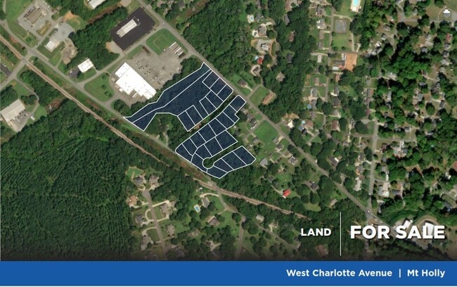
Property Record
W Central Ave, , NC
NEARBY LISTINGS FOR SALE OR LEASE
Property Detail
W Central Ave
211098
BRIARWOOD VILLAGE L 13 03 023 006 00 000
Vacantlandnec
Gaston
X
North Carolina
3710359700J
0.23 AC
2025
Gaston County
2025
Charlotte
031101
Charlotte-Concord-Gastonia, NC-SC
DEMOGRAPHICS near W Central Ave
1 Mile
3 Mile
5 Mile
2024 Total Population
4,751
32,098
80,038
2029 Population
5,070
34,280
85,664
Pop Growth 2024-2029
+ 6.71%
+ 6.80%
+ 7.03%
Average Age
40
39
39
2024 Total Households
1,968
12,655
31,487
HH Growth 2024-2029
+ 6.86%
+ 6.97%
+ 7.25%
Median Household Inc
$55,945
$61,802
$65,948
Avg Household Size
2.40
2.40
2.50
2024 Avg HH Vehicles
2.00
2.00
2.00
Median Home Value
$201,152
$218,664
$236,951
Median Year Built
1980
1989
1993
Nearby Places
Map Layers
Map Styles
 Street
 Aerial
- Restaurants
- Banks
- Shops
- Fitness
- Groceries
PUBLIC TRANSPORTATION
AIRPORT
Charlotte/Douglas International
DRIVE
WALK
Distance
Charlotte/Douglas International
26 min
11.2 mi
Concord-Padgett Regional
DRIVE
WALK
Distance
Concord-Padgett Regional
31 min
21.2 mi
Freight Ports
North Charleston Terminal
DRIVE
WALK
Distance
North Charleston Terminal
237 min
207.6 mi
SALE & LEASE HISTORY
LISTING DATE
SALE/LEASE

Nov 30, 2022
For Sale
Nearby Properties
Address
Land Use
TOTAL SIZE
Lot Size
Zoning
Address
Land Use
TOTAL SIZE
Lot Size
Zoning
41,508 SF
29.70 AC
Address
Land Use
TOTAL SIZE
Lot Size
Zoning
43.38 AC
Address
Land Use
TOTAL SIZE
Lot Size
Zoning
1,966 SF
36.06 AC
OFF01
Address
Land Use
TOTAL SIZE
Lot Size
Zoning
437,434 SF
150.02 AC
MANU1
Address
Land Use
TOTAL SIZE
Lot Size
Zoning
25.64 AC
Address
Land Use
TOTAL SIZE
Lot Size
Zoning
208,635 SF
50.01 AC
Address
Land Use
TOTAL SIZE
Lot Size
Zoning
171,037 SF
4.37 AC
Address
Land Use
TOTAL SIZE
Lot Size
Zoning
13,090 SF
93.97 AC
INDS2
Address
Land Use
TOTAL SIZE
Lot Size
Zoning
25.14 AC
Address
Land Use
TOTAL SIZE
Lot Size
Zoning
358,450 SF
23.50 AC
STOR2
Address
Land Use
TOTAL SIZE
Lot Size
Zoning
3,536 SF
12.07 AC
APT02
Address
Land Use
TOTAL SIZE
Lot Size
Zoning
6,720 SF
60.15 AC
PUB01
Address
Land Use
TOTAL SIZE
Lot Size
Zoning
136,318 SF
4.13 AC
I1
Address
Land Use
TOTAL SIZE
Lot Size
Zoning
46,998 SF
30.47 AC
HCAR1
Address
Land Use
TOTAL SIZE
Lot Size
Zoning
75,208 SF
15.55 AC
R-3
Address
Land Use
TOTAL SIZE
Lot Size
Zoning
8,512 SF
102.15 AC
R-3
Address
Land Use
TOTAL SIZE
Lot Size
Zoning
99.28 AC
BCD
Address
Land Use
TOTAL SIZE
Lot Size
Zoning
21.61 AC
Address
Land Use
TOTAL SIZE
Lot Size
Zoning
58,553 SF
7.78 AC
B1CD
Address
Land Use
TOTAL SIZE
Lot Size
Zoning
102,500 SF
117.14 AC
INDS1
Address
Land Use
TOTAL SIZE
Lot Size
Zoning
968 SF
6.46 AC
OFF01
Address
Land Use
TOTAL SIZE
Lot Size
Zoning
20.02 AC
R-12MF(CD)
Address
Land Use
TOTAL SIZE
Lot Size
Zoning
81,441 SF
4.45 AC
Address
Land Use
TOTAL SIZE
Lot Size
Zoning
1,693 SF
86 AC
MX-2
Address
Land Use
TOTAL SIZE
Lot Size
Zoning
Address
Land Use
TOTAL SIZE
Lot Size
Zoning
44,244 SF
8.21 AC
Address
Land Use
TOTAL SIZE
Lot Size
Zoning
112 AC
R-3
Address
Land Use
TOTAL SIZE
Lot Size
Zoning
1,671 SF
8.09 AC
OFF01
Address
Land Use
TOTAL SIZE
Lot Size
Zoning
368,527 SF
329.43 AC
Address
Land Use
TOTAL SIZE
Lot Size
Zoning
111,844 SF
11.96 AC
STOR2
The World's #1 Commercial Real Estate Marketplace
Connect with us
© 2025 CoStar Group
The information above has been obtained from sources believed reliable. While we do not doubt its accuracy we have not verified it and make no guarantee, warranty or representation about it. It is your responsibility to independently confirm its accuracy and completeness. Any projections, opinions, assumptions, or estimates used are for example only and do not represent the current or future performance of the property. The value of this transaction to you depends on tax and other factors which should be evaluated by your tax, financial, and legal advisors. You and your advisors should conduct a careful, independent investigation of the property to determine to your satisfaction the suitability of the property for your needs.