Property Record
701 Common Pl, Adel, IA 50003

NEARBY LISTINGS FOR SALE OR LEASE
-
-
View all Adel listings for lease on LoopNet.com
Property Detail
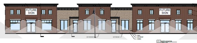
701 Common Pl
Des Moines
Southbridge Plat 3
Des Moines-West Des Moines, IA
Dallas
15-06-107-002
Iowa
Residentialnec
1.71 AC
X
Outlying Dallas County
19049C0329G
DEMOGRAPHICS near 701 Common Pl
1 Mile
3 Mile
5 Mile
2024 Total Population
2,136
8,383
11,145
2029 Population
2,560
9,985
13,241
Pop Growth 2024-2029
+ 19.85%
+ 19.11%
+ 18.81%
Average Age
36
38
38
2024 Total Households
775
3,131
4,161
HH Growth 2024-2029
+ 20.77%
+ 19.90%
+ 19.61%
Median Household Inc
$79,839
$69,617
$73,585
Avg Household Size
2.70
2.70
2.70
2024 Avg HH Vehicles
2.00
2.00
2.00
Median Home Value
$270,258
$256,873
$250,377
Median Year Built
2010
1991
1988
Nearby Places
Map Layers
Map Styles
 Street
 Aerial
- Restaurants
- Banks
- Shops
- Fitness
- Groceries
PUBLIC TRANSPORTATION
AIRPORT
Des Moines International
DRIVE
WALK
Distance
Des Moines International
38 min
26.5 mi
Freight Ports
Port Milwaukee
DRIVE
WALK
Distance
Port Milwaukee
443 min
394.6 mi
SALE & LEASE HISTORY
LISTING DATE
SALE/LEASE

May 08, 2025
For Lease
May 06, 2025
For Sale
Nearby Properties
Address
Land Use
TOTAL SIZE
Lot Size
Zoning
Address
Land Use
TOTAL SIZE
Lot Size
Zoning
0.92 AC
Address
Land Use
TOTAL SIZE
Lot Size
Zoning
159,594 SF
38.62 AC
Address
Land Use
TOTAL SIZE
Lot Size
Zoning
Address
Land Use
TOTAL SIZE
Lot Size
Zoning
19.02 AC
Address
Land Use
TOTAL SIZE
Lot Size
Zoning
28,572 SF
1.70 AC
Address
Land Use
TOTAL SIZE
Lot Size
Zoning
8,262 SF
12.61 AC
Address
Land Use
TOTAL SIZE
Lot Size
Zoning
16 AC
Address
Land Use
TOTAL SIZE
Lot Size
Zoning
3.79 AC
Address
Land Use
TOTAL SIZE
Lot Size
Zoning
4,950 SF
2.66 AC
Address
Land Use
TOTAL SIZE
Lot Size
Zoning
99,602 SF
5.40 AC
Address
Land Use
TOTAL SIZE
Lot Size
Zoning
5,952 SF
8.62 AC
Address
Land Use
TOTAL SIZE
Lot Size
Zoning
3,029 SF
5.57 AC
Address
Land Use
TOTAL SIZE
Lot Size
Zoning
11,880 SF
5 AC
Address
Land Use
TOTAL SIZE
Lot Size
Zoning
2,820 SF
11.25 AC
Address
Land Use
TOTAL SIZE
Lot Size
Zoning
14,748 SF
6.75 AC
Address
Land Use
TOTAL SIZE
Lot Size
Zoning
4,775 SF
2.11 AC
Address
Land Use
TOTAL SIZE
Lot Size
Zoning
2,432 SF
20.33 AC
Address
Land Use
TOTAL SIZE
Lot Size
Zoning
16,679 SF
5.44 AC
Address
Land Use
TOTAL SIZE
Lot Size
Zoning
8,435 SF
0.42 AC
Address
Land Use
TOTAL SIZE
Lot Size
Zoning
19,078 SF
2.57 AC
Address
Land Use
TOTAL SIZE
Lot Size
Zoning
13,777 SF
13.48 AC
Address
Land Use
TOTAL SIZE
Lot Size
Zoning
22,297 SF
8.51 AC
Address
Land Use
TOTAL SIZE
Lot Size
Zoning
1.46 AC
Address
Land Use
TOTAL SIZE
Lot Size
Zoning
21,875 SF
3.11 AC
Address
Land Use
TOTAL SIZE
Lot Size
Zoning
5,643 SF
2.25 AC
Address
Land Use
TOTAL SIZE
Lot Size
Zoning
2,860 SF
7.50 AC
Address
Land Use
TOTAL SIZE
Lot Size
Zoning
24,000 SF
3.10 AC
Address
Land Use
TOTAL SIZE
Lot Size
Zoning
12,000 SF
3.50 AC
Address
Land Use
TOTAL SIZE
Lot Size
Zoning
4,930 SF
0.80 AC
The World's #1 Commercial Real Estate Marketplace
Connect with us
© 2025 CoStar Group
The information above has been obtained from sources believed reliable. While we do not doubt its accuracy we have not verified it and make no guarantee, warranty or representation about it. It is your responsibility to independently confirm its accuracy and completeness. Any projections, opinions, assumptions, or estimates used are for example only and do not represent the current or future performance of the property. The value of this transaction to you depends on tax and other factors which should be evaluated by your tax, financial, and legal advisors. You and your advisors should conduct a careful, independent investigation of the property to determine to your satisfaction the suitability of the property for your needs.