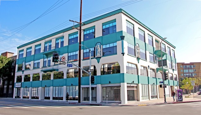
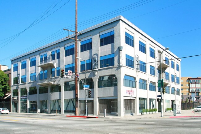
Property Record
701 E 3Rd St, Los Angeles, CA 90013

Current Lease Availabilities
NEARBY LISTINGS FOR SALE OR LEASE
Property Detail
701 E 3Rd St
Los Angeles-Long Beach-Glendale, CA
Johnston Tract
5163-009-902
JOHNSTON TRACT EX OF STS LOT 17 AND EX OF ST LOT 18 BLK B
Officebuilding
Los Angeles
X
California
06037C1636G
17,18
0
0.33 AC
2025
Downtown Los Angeles
206052
Los Angeles
54,017 SF
DEMOGRAPHICS near 701 E 3Rd St
1 mile
3 mile
5 mile
2024 Total Population
49,184
416,112
1,105,129
2029 Population
48,173
403,128
1,066,269
Pop Growth 2024-2029
(2.06%)
(3.12%)
(3.52%)
Average Age
43
37
38
2024 Total Households
21,190
148,346
377,026
HH Growth 2024-2029
(2.15%)
(2.81%)
(3.36%)
Median Household Inc
$40,953
$49,029
$53,661
Avg Household Size
1.60
2.50
2.70
2024 Avg HH Vehicles
1.00
1.00
1.00
Median Home Value
$786,092
$733,739
$761,772
Median Year Built
1977
1964
1957
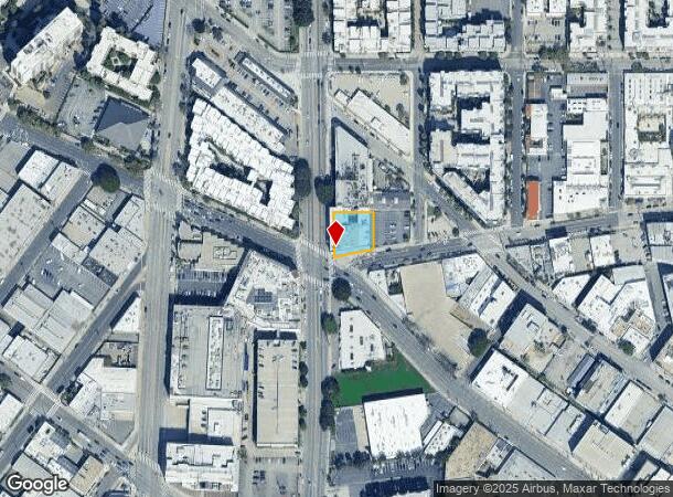
Nearby Places
Map Layers
Map Styles
 Street
 Aerial
Transit
 Traffic
 Biking
Places
Listings with unknown addresses are not visible on the map
- Restaurants
- Banks
- Shops
- Fitness
- Groceries
PUBLIC TRANSPORTATION
COMMUTER RAIL
Drive
Walk
Distance
3 min
15 min
0.8 mi
Union Station (91 Line - Southern California Regional Rail Authority (Metrolink), Antelope Valley Line - Southern California Regional Rail Authority (Metrolink), Orange County Line - Southern California Regional Rail Authority (Metrolink), Riverside Line - Southern California Regional Rail Authority (Metrolink), San Bernardino Line - Southern California Regional Rail Authority (Metrolink), Ventura County Line - Southern California Regional Rail Authority (Metrolink))
Drive
Walk
Distance
Union Station (91 Line - Southern California Regional Rail Authority (Metrolink), Antelope Valley Line - Southern California Regional Rail Authority (Metrolink), Orange County Line - Southern California Regional Rail Authority (Metrolink), Riverside Line - Southern California Regional Rail Authority (Metrolink), San Bernardino Line - Southern California Regional Rail Authority (Metrolink), Ventura County Line - Southern California Regional Rail Authority (Metrolink))
5 min
18 min
0.9 mi
AIRPORT
Bob Hope
Drive
Walk
Distance
Bob Hope
26 min
15.4 mi
Los Angeles International
Drive
Walk
Distance
Los Angeles International
27 min
19.3 mi
Long Beach (Daugherty Field)
Drive
Walk
Distance
Long Beach (Daugherty Field)
32 min
22.1 mi
Freight Ports
Port of Long Beach
Drive
Walk
Distance
Port of Long Beach
34 min
24.0 mi
Nearby Properties
Address
Land Use
TOTAL SIZE
Lot Size
Zoning
Address
Land Use
TOTAL SIZE
Lot Size
Zoning
2,832,748 SF
4.20 AC
LAC2
Address
Land Use
TOTAL SIZE
Lot Size
Zoning
1,392,719 SF
4.22 AC
LAC4
Address
Land Use
TOTAL SIZE
Lot Size
Zoning
2,001,034 SF
2.71 AC
LAC2
Address
Land Use
TOTAL SIZE
Lot Size
Zoning
108,464 SF
9.17 AC
LALASED
Address
Land Use
TOTAL SIZE
Lot Size
Zoning
969,264 SF
0.94 AC
LAC2
Address
Land Use
TOTAL SIZE
Lot Size
Zoning
717,065 SF
0.99 AC
LAC2
Address
Land Use
TOTAL SIZE
Lot Size
Zoning
1,039,642 SF
2.84 AC
LAC2
Address
Land Use
TOTAL SIZE
Lot Size
Zoning
1,486,375 SF
3.77 AC
LAR5
Address
Land Use
TOTAL SIZE
Lot Size
Zoning
1,457,208 SF
1.39 AC
LAC2
Address
Land Use
TOTAL SIZE
Lot Size
Zoning
949,529 SF
1.50 AC
LAC2
Address
Land Use
TOTAL SIZE
Lot Size
Zoning
200,811 SF
4.59 AC
LALASED
Address
Land Use
TOTAL SIZE
Lot Size
Zoning
1,178,786 SF
3.89 AC
LAC2
Address
Land Use
TOTAL SIZE
Lot Size
Zoning
764,804 SF
1.48 AC
Address
Land Use
TOTAL SIZE
Lot Size
Zoning
634,863 SF
2.97 AC
LAC2-4D
Address
Land Use
TOTAL SIZE
Lot Size
Zoning
1,346,113 SF
1.17 AC
LAC5
Address
Land Use
TOTAL SIZE
Lot Size
Zoning
738,975 SF
2.71 AC
LAC2
Address
Land Use
TOTAL SIZE
Lot Size
Zoning
1,094,768 SF
0.73 AC
LAC2
Address
Land Use
TOTAL SIZE
Lot Size
Zoning
574,047 SF
1.70 AC
LAR5
Address
Land Use
TOTAL SIZE
Lot Size
Zoning
705,234 SF
1.83 AC
LAC2
Address
Land Use
TOTAL SIZE
Lot Size
Zoning
966,466 SF
3.99 AC
LAC2
Address
Land Use
TOTAL SIZE
Lot Size
Zoning
816,046 SF
15.37 AC
LAA1
Address
Land Use
TOTAL SIZE
Lot Size
Zoning
773,409 SF
1.39 AC
LAC4
Address
Land Use
TOTAL SIZE
Lot Size
Zoning
1,005,477 SF
1.36 AC
LAC4
Address
Land Use
TOTAL SIZE
Lot Size
Zoning
2,697,158 SF
20.18 AC
LAM2
Address
Land Use
TOTAL SIZE
Lot Size
Zoning
641,453 SF
2.93 AC
LAC4
Address
Land Use
TOTAL SIZE
Lot Size
Zoning
581,956 SF
0.89 AC
LAR5
Address
Land Use
TOTAL SIZE
Lot Size
Zoning
1,207,589 SF
1.01 AC
LAC2
Address
Land Use
TOTAL SIZE
Lot Size
Zoning
651,289 SF
3.79 AC
LACW
Address
Land Use
TOTAL SIZE
Lot Size
Zoning
1.28 AC
LAC2
Address
Land Use
TOTAL SIZE
Lot Size
Zoning
387,421 SF
1.08 AC
LAR5
The World's #1 Commercial Real Estate Marketplace
Connect with us
© 2026 CoStar Group
The information above has been obtained from sources believed reliable. While we do not doubt its accuracy we have not verified it and make no guarantee, warranty or representation about it. It is your responsibility to independently confirm its accuracy and completeness. Any projections, opinions, assumptions, or estimates used are for example only and do not represent the current or future performance of the property. The value of this transaction to you depends on tax and other factors which should be evaluated by your tax, financial, and legal advisors. You and your advisors should conduct a careful, independent investigation of the property to determine to your satisfaction the suitability of the property for your needs.