Property Record
701 E 60Th St N, Sioux Falls, SD 57104
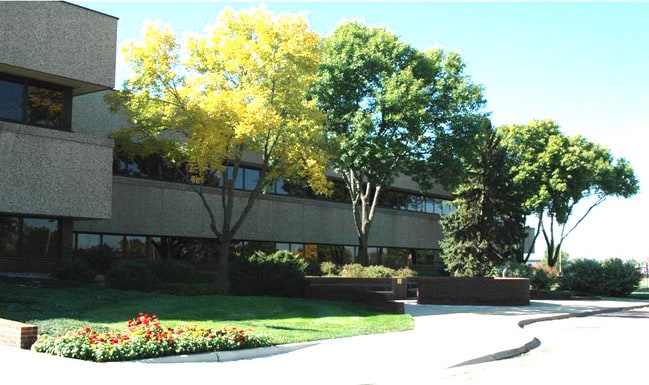

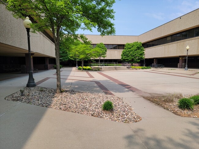
This Property Is For Sale
Property Detail
701 E 60Th St N
46833
TRACT 5 SIOUX EMPIRE DEVELOPMENT PARK TWO ADDN TO CITY OF SIOUX FALL
Officebuilding
Minnehaha
NO;SPECIAL
South Dakota
2025
15 AC
2025
Sioux Falls
000100
Other Market Areas
123,028 SF
Sioux Falls, SD-MN
NEARBY LISTINGS FOR SALE OR LEASE
DEMOGRAPHICS near 701 E 60Th St N
1 mile
3 mile
5 mile
2025 Total Population
498
9,641
72,541
2030 Population
513
10,029
76,364
Pop Growth 2025-2030
+ 3.01%
+ 4.02%
+ 5.27%
Average Age
44
41
38
2025 Total Households
209
3,377
30,167
HH Growth 2025-2030
+ 2.87%
+ 4.59%
+ 5.75%
Median Household Inc
$71,517
$60,539
$63,478
Avg Household Size
2.40
2.30
2.20
2025 Avg HH Vehicles
2.00
2.00
2.00
Median Home Value
$258,749
$191,863
$243,640
Median Year Built
1993
1978
1977
Nearby Places
Map Layers
Map Styles
 Street
 Aerial
Layers
 Traffic
 Biking
Places
Listings with unknown addresses are not visible on the map
- Restaurants
- Banks
- Shops
- Fitness
- Groceries
PUBLIC TRANSPORTATION
AIRPORT
Joe Foss Field
Drive
Walk
Distance
Joe Foss Field
22 min
6.2 mi
Freight Ports
Port Milwaukee
Drive
Walk
Distance
Port Milwaukee
542 min
500.1 mi
Nearby Properties
Address
Land Use
TOTAL SIZE
Lot Size
Zoning
Address
Land Use
TOTAL SIZE
Lot Size
Zoning
349,950 SF
32.99 AC
Address
Land Use
TOTAL SIZE
Lot Size
Zoning
14,820 SF
80.57 AC
FP;FP
Address
Land Use
TOTAL SIZE
Lot Size
Zoning
5,725 SF
77.41 AC
Address
Land Use
TOTAL SIZE
Lot Size
Zoning
227,743 SF
90.58 AC
Address
Land Use
TOTAL SIZE
Lot Size
Zoning
212,076 SF
41.01 AC
FP;FP
Address
Land Use
TOTAL SIZE
Lot Size
Zoning
140,816 SF
13.80 AC
Address
Land Use
TOTAL SIZE
Lot Size
Zoning
50,160 SF
24.88 AC
Address
Land Use
TOTAL SIZE
Lot Size
Zoning
Address
Land Use
TOTAL SIZE
Lot Size
Zoning
123,441 SF
14.41 AC
Address
Land Use
TOTAL SIZE
Lot Size
Zoning
15,000 SF
29.88 AC
Address
Land Use
TOTAL SIZE
Lot Size
Zoning
205,572 SF
22.50 AC
Address
Land Use
TOTAL SIZE
Lot Size
Zoning
35,688 SF
8.27 AC
FP;FP
Address
Land Use
TOTAL SIZE
Lot Size
Zoning
33,416 SF
9.87 AC
Address
Land Use
TOTAL SIZE
Lot Size
Zoning
171,429 SF
18.37 AC
Address
Land Use
TOTAL SIZE
Lot Size
Zoning
173,905 SF
10 AC
Address
Land Use
TOTAL SIZE
Lot Size
Zoning
134,102 SF
11.77 AC
Address
Land Use
TOTAL SIZE
Lot Size
Zoning
62,856 SF
11.26 AC
Address
Land Use
TOTAL SIZE
Lot Size
Zoning
189,312 SF
23.87 AC
Address
Land Use
TOTAL SIZE
Lot Size
Zoning
239,450 SF
21.92 AC
NO;SPECIAL
Address
Land Use
TOTAL SIZE
Lot Size
Zoning
58,825 SF
20.09 AC
Address
Land Use
TOTAL SIZE
Lot Size
Zoning
124,103 SF
28.18 AC
Address
Land Use
TOTAL SIZE
Lot Size
Zoning
127,500 SF
13.04 AC
Address
Land Use
TOTAL SIZE
Lot Size
Zoning
85,272 SF
4.83 AC
Address
Land Use
TOTAL SIZE
Lot Size
Zoning
1,806 SF
170.92 AC
FP;FP
Address
Land Use
TOTAL SIZE
Lot Size
Zoning
120,000 SF
13.08 AC
Address
Land Use
TOTAL SIZE
Lot Size
Zoning
123,702 SF
7.03 AC
FP;FP
Address
Land Use
TOTAL SIZE
Lot Size
Zoning
133,119 SF
12.89 AC
Address
Land Use
TOTAL SIZE
Lot Size
Zoning
12,454 SF
13.30 AC
Address
Land Use
TOTAL SIZE
Lot Size
Zoning
5,040 SF
7.06 AC
Address
Land Use
TOTAL SIZE
Lot Size
Zoning
212,500 SF
12 AC
The World's #1 Commercial Real Estate Marketplace
Connect with us
© 2026 CoStar Group
The information above has been obtained from sources believed reliable. While we do not doubt its accuracy we have not verified it and make no guarantee, warranty or representation about it. It is your responsibility to independently confirm its accuracy and completeness. Any projections, opinions, assumptions, or estimates used are for example only and do not represent the current or future performance of the property. The value of this transaction to you depends on tax and other factors which should be evaluated by your tax, financial, and legal advisors. You and your advisors should conduct a careful, independent investigation of the property to determine to your satisfaction the suitability of the property for your needs.