Property Record
701 E Military Hwy, Progreso, TX

NEARBY LISTINGS FOR SALE OR LEASE
-
-
View all Progreso listings for sale on LoopNet.com
Property Detail
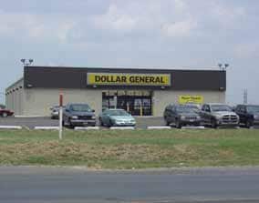
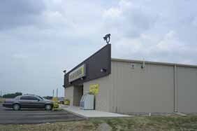
701 E Military Hwy
McAllen/Edinburg/Pharr
Dollar General Progreso
McAllen-Edinburg-Mission, TX
DOLLAR GENERAL PROGRESO LOT 1
D6118-00-000-0001-00
Hidalgo
Commercialnec
Texas
2024
1
2025
1.47 AC
024107
Outlying Hidalgo County
11,900 SF
DEMOGRAPHICS near 701 E Military Hwy
1 Mile
3 Mile
5 Mile
2024 Total Population
1,349
7,636
36,366
2029 Population
1,326
7,862
38,837
Pop Growth 2024-2029
(1.70%)
+ 2.96%
+ 6.79%
Average Age
33
38
39
2024 Total Households
349
2,297
11,995
HH Growth 2024-2029
(2.01%)
+ 4.53%
+ 7.56%
Median Household Inc
$51,983
$39,064
$45,235
Avg Household Size
3.80
3.30
2.90
2024 Avg HH Vehicles
2.00
2.00
2.00
Median Home Value
$104,615
$83,986
$85,879
Median Year Built
1996
1995
1992
Nearby Places
Map Layers
Map Styles
 Street
 Aerial
- Restaurants
- Banks
- Shops
- Fitness
- Groceries
PUBLIC TRANSPORTATION
AIRPORT
McAllen International
DRIVE
WALK
Distance
McAllen International
34 min
24.8 mi
Valley International
DRIVE
WALK
Distance
Valley International
47 min
28.7 mi
Brownsville/South Padre Island International
DRIVE
WALK
Distance
Brownsville/South Padre Island International
59 min
37.5 mi
Freight Ports
Port of Brownsville
DRIVE
WALK
Distance
Port of Brownsville
56 min
47.0 mi
Nearby Properties
Address
Land Use
TOTAL SIZE
Lot Size
Zoning
Address
Land Use
TOTAL SIZE
Lot Size
Zoning
184,092 SF
17.61 AC
Address
Land Use
TOTAL SIZE
Lot Size
Zoning
76,484 SF
20.60 AC
Address
Land Use
TOTAL SIZE
Lot Size
Zoning
3 SF
16.78 AC
Address
Land Use
TOTAL SIZE
Lot Size
Zoning
1 SF
12.23 AC
Address
Land Use
TOTAL SIZE
Lot Size
Zoning
1 SF
21.22 AC
Address
Land Use
TOTAL SIZE
Lot Size
Zoning
1,126,582 SF
14.76 AC
Address
Land Use
TOTAL SIZE
Lot Size
Zoning
52,926 SF
9.89 AC
Address
Land Use
TOTAL SIZE
Lot Size
Zoning
57,123 SF
8.28 AC
Address
Land Use
TOTAL SIZE
Lot Size
Zoning
1,668,585 SF
2.08 AC
Address
Land Use
TOTAL SIZE
Lot Size
Zoning
61,186 SF
10 AC
Address
Land Use
TOTAL SIZE
Lot Size
Zoning
34.22 AC
Address
Land Use
TOTAL SIZE
Lot Size
Zoning
1,456 SF
55.36 AC
Address
Land Use
TOTAL SIZE
Lot Size
Zoning
4 SF
8.90 AC
Address
Land Use
TOTAL SIZE
Lot Size
Zoning
55.15 AC
Address
Land Use
TOTAL SIZE
Lot Size
Zoning
1 SF
11.55 AC
Address
Land Use
TOTAL SIZE
Lot Size
Zoning
53.75 AC
Address
Land Use
TOTAL SIZE
Lot Size
Zoning
22,020 SF
9.70 AC
Address
Land Use
TOTAL SIZE
Lot Size
Zoning
17,756 SF
14.76 AC
Address
Land Use
TOTAL SIZE
Lot Size
Zoning
22,000 SF
20.10 AC
Address
Land Use
TOTAL SIZE
Lot Size
Zoning
10,380 SF
1.35 AC
Address
Land Use
TOTAL SIZE
Lot Size
Zoning
25,458 SF
11.89 AC
Address
Land Use
TOTAL SIZE
Lot Size
Zoning
10,626 SF
2.08 AC
Address
Land Use
TOTAL SIZE
Lot Size
Zoning
24,500 SF
6.35 AC
Address
Land Use
TOTAL SIZE
Lot Size
Zoning
18,298 SF
14.05 AC
Address
Land Use
TOTAL SIZE
Lot Size
Zoning
16,574 SF
15.49 AC
Address
Land Use
TOTAL SIZE
Lot Size
Zoning
300 SF
26.48 AC
Address
Land Use
TOTAL SIZE
Lot Size
Zoning
Address
Land Use
TOTAL SIZE
Lot Size
Zoning
119 SF
9.97 AC
M4
Address
Land Use
TOTAL SIZE
Lot Size
Zoning
21.52 AC
The World's #1 Commercial Real Estate Marketplace
Connect with us
© 2025 CoStar Group
The information above has been obtained from sources believed reliable. While we do not doubt its accuracy we have not verified it and make no guarantee, warranty or representation about it. It is your responsibility to independently confirm its accuracy and completeness. Any projections, opinions, assumptions, or estimates used are for example only and do not represent the current or future performance of the property. The value of this transaction to you depends on tax and other factors which should be evaluated by your tax, financial, and legal advisors. You and your advisors should conduct a careful, independent investigation of the property to determine to your satisfaction the suitability of the property for your needs.