Property Record
701 E Sprague St, Winston Salem, NC 27107


Save to a Folder
{{folder.Name}}
{{folder.ListingIds.length}} Properties
{{folder.ListingIds.length}} Property
Create a New Folder
Property Detail
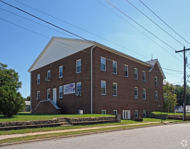
701 E Sprague St
6834-86-2152
IGLESIA BAUTISTA CRISTO VIVE LO:002 BL:0737 BU:1
Religious
Forsyth
RS9
North Carolina
B and X Area of moderate flood hazard, usually the area between the limits of the 100-year and 500-year floods.
2
2023
0.51 AC
2025
SE Forsyth County
000802
Greensboro/Winston-Salem
7,320 SF
Winston-Salem, NC
NEARBY LISTINGS FOR SALE OR LEASE
-
-
View all Winston Salem listings for sale on LoopNet.com
DEMOGRAPHICS near 701 E Sprague St
1 mile
3 mile
5 mile
2025 Total Population
12,046
64,901
141,637
2030 Population
12,489
67,421
146,998
Pop Growth 2025-2030
+ 3.68%
+ 3.88%
+ 3.79%
Average Age
32
36
38
2025 Total Households
3,355
26,516
58,592
HH Growth 2025-2030
+ 4.08%
+ 4.28%
+ 4.04%
Median Household Inc
$37,085
$48,767
$56,283
Avg Household Size
2.70
2.20
2.30
2025 Avg HH Vehicles
2.00
1.00
2.00
Median Home Value
$115,212
$196,560
$228,019
Median Year Built
1956
1970
1975
Nearby Places
Map Layers
Map Styles
 Street
 Aerial
Layers
 Traffic
 Biking
Places
Listings with unknown addresses are not visible on the map
- Restaurants
- Banks
- Shops
- Fitness
- Groceries
PUBLIC TRANSPORTATION
AIRPORT
Piedmont Triad International
Drive
Walk
Distance
Piedmont Triad International
31 min
19.9 mi
Freight Ports
Virginia Port Authority - Richmond
Drive
Walk
Distance
Virginia Port Authority - Richmond
258 min
223.5 mi
Nearby Properties
Address
Land Use
TOTAL SIZE
Lot Size
Zoning
Address
Land Use
TOTAL SIZE
Lot Size
Zoning
368,715 SF
4.11 AC
CI
Address
Land Use
TOTAL SIZE
Lot Size
Zoning
100 SF
2.59 AC
C
Address
Land Use
TOTAL SIZE
Lot Size
Zoning
205,729 SF
2.35 AC
CI
Address
Land Use
TOTAL SIZE
Lot Size
Zoning
244,516 SF
4.42 AC
CI
Address
Land Use
TOTAL SIZE
Lot Size
Zoning
123,109 SF
65.07 AC
C,HB,LO-S
Address
Land Use
TOTAL SIZE
Lot Size
Zoning
127,530 SF
2.52 AC
C
Address
Land Use
TOTAL SIZE
Lot Size
Zoning
100 SF
1.53 AC
C
Address
Land Use
TOTAL SIZE
Lot Size
Zoning
297,475 SF
3.06 AC
CI-S
Address
Land Use
TOTAL SIZE
Lot Size
Zoning
315,590 SF
2 AC
CB
Address
Land Use
TOTAL SIZE
Lot Size
Zoning
156,507 SF
NULL
Address
Land Use
TOTAL SIZE
Lot Size
Zoning
121,886 SF
3.92 AC
PB-S
Address
Land Use
TOTAL SIZE
Lot Size
Zoning
100 SF
37.41 AC
C,H
Address
Land Use
TOTAL SIZE
Lot Size
Zoning
202,752 SF
3.43 AC
PB-L
Address
Land Use
TOTAL SIZE
Lot Size
Zoning
100 SF
2.71 AC
C
Address
Land Use
TOTAL SIZE
Lot Size
Zoning
352,549 SF
2.30 AC
CB WO
Address
Land Use
TOTAL SIZE
Lot Size
Zoning
140,472 SF
1.33 AC
CB WO
Address
Land Use
TOTAL SIZE
Lot Size
Zoning
153,315 SF
2.07 AC
CI
Address
Land Use
TOTAL SIZE
Lot Size
Zoning
195,551 SF
2.07 AC
CI
Address
Land Use
TOTAL SIZE
Lot Size
Zoning
200 SF
8.16 AC
PB-S
Address
Land Use
TOTAL SIZE
Lot Size
Zoning
154,655 SF
0.76 AC
CI
Address
Land Use
TOTAL SIZE
Lot Size
Zoning
160,152 SF
26 AC
RM12-S,RM1
Address
Land Use
TOTAL SIZE
Lot Size
Zoning
205,979 SF
1.73 AC
CB WO
Address
Land Use
TOTAL SIZE
Lot Size
Zoning
207,203 SF
4.26 AC
PB
Address
Land Use
TOTAL SIZE
Lot Size
Zoning
70,376 SF
2.86 AC
PB-S
Address
Land Use
TOTAL SIZE
Lot Size
Zoning
106,204 SF
1.13 AC
CI
Address
Land Use
TOTAL SIZE
Lot Size
Zoning
162,844 SF
57.77 AC
IP
Address
Land Use
TOTAL SIZE
Lot Size
Zoning
124,134 SF
2.14 AC
CB WO
Address
Land Use
TOTAL SIZE
Lot Size
Zoning
121,925 SF
1.49 AC
GO
Address
Land Use
TOTAL SIZE
Lot Size
Zoning
115,340 SF
2.10 AC
CI
Address
Land Use
TOTAL SIZE
Lot Size
Zoning
56,975 SF
0.26 AC
CB WO
The World's #1 Commercial Real Estate Marketplace
Connect with us
© 2026 CoStar Group
The information above has been obtained from sources believed reliable. While we do not doubt its accuracy we have not verified it and make no guarantee, warranty or representation about it. It is your responsibility to independently confirm its accuracy and completeness. Any projections, opinions, assumptions, or estimates used are for example only and do not represent the current or future performance of the property. The value of this transaction to you depends on tax and other factors which should be evaluated by your tax, financial, and legal advisors. You and your advisors should conduct a careful, independent investigation of the property to determine to your satisfaction the suitability of the property for your needs.