Property Record
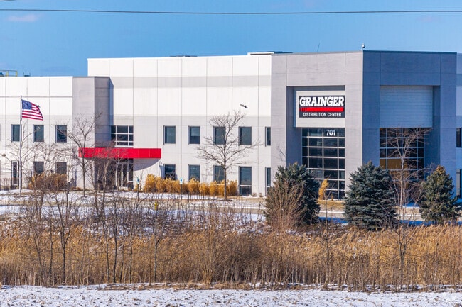
701 Grainger Way, Minooka, IL 60447

Property Detail
701 Grainger Way
Chicago-Naperville-Elgin, IL-IN
AMB SUB PT LT 1 - BEG 74.22'SE & 200.58'NE NW COR, NE631.5' SE1701' SE631.5' NW1701' TO POB SEC 2-34-8
03-02-200-024
GRUNDY
Industrialgeneral
Illinois
B and X Area of moderate flood hazard, usually the area between the limits of the 100-year and 500-year floods.
1
2024
24.66 AC
2024
Grundy County
000102
Chicago
1,000,800 SF
NEARBY LISTINGS FOR SALE OR LEASE
-
-
View all Minooka listings for sale on LoopNet.com
DEMOGRAPHICS near 701 Grainger Way
1 mile
3 mile
5 mile
2025 Total Population
1,016
16,863
39,868
2030 Population
1,038
17,256
40,873
Pop Growth 2025-2030
+ 2.17%
+ 2.33%
+ 2.52%
Average Age
38
37
39
2025 Total Households
351
5,583
13,608
HH Growth 2025-2030
+ 2.28%
+ 2.24%
+ 2.48%
Median Household Inc
$99,553
$114,291
$117,132
Avg Household Size
2.80
3.00
2.90
2025 Avg HH Vehicles
3.00
2.00
2.00
Median Home Value
$277,659
$306,753
$325,971
Median Year Built
1991
2002
2001
Nearby Places
Map Layers
Map Styles
 Street
 Aerial
Transit
 Traffic
 Biking
Places
Listings with unknown addresses are not visible on the map
- Restaurants
- Banks
- Shops
- Fitness
- Groceries
Nearby Properties
Address
Land Use
TOTAL SIZE
Lot Size
Zoning
Address
Land Use
TOTAL SIZE
Lot Size
Zoning
73.42 AC
Address
Land Use
TOTAL SIZE
Lot Size
Zoning
79.57 AC
Address
Land Use
TOTAL SIZE
Lot Size
Zoning
364 SF
48.93 AC
Address
Land Use
TOTAL SIZE
Lot Size
Zoning
19.57 AC
Address
Land Use
TOTAL SIZE
Lot Size
Zoning
1,034,100 SF
54.99 AC
Address
Land Use
TOTAL SIZE
Lot Size
Zoning
15,600 SF
7.60 AC
Address
Land Use
TOTAL SIZE
Lot Size
Zoning
35.52 AC
Address
Land Use
TOTAL SIZE
Lot Size
Zoning
872,032 SF
43.10 AC
Address
Land Use
TOTAL SIZE
Lot Size
Zoning
598,380 SF
32.69 AC
Address
Land Use
TOTAL SIZE
Lot Size
Zoning
861,000 SF
47.22 AC
Address
Land Use
TOTAL SIZE
Lot Size
Zoning
306,240 SF
19.99 AC
Address
Land Use
TOTAL SIZE
Lot Size
Zoning
456,860 SF
35.47 AC
Address
Land Use
TOTAL SIZE
Lot Size
Zoning
107,428 SF
17.69 AC
Address
Land Use
TOTAL SIZE
Lot Size
Zoning
134,300 SF
18.29 AC
Address
Land Use
TOTAL SIZE
Lot Size
Zoning
24.22 AC
Address
Land Use
TOTAL SIZE
Lot Size
Zoning
60,804 SF
7.29 AC
Address
Land Use
TOTAL SIZE
Lot Size
Zoning
77,000 SF
7.43 AC
Address
Land Use
TOTAL SIZE
Lot Size
Zoning
3,360 SF
43.42 AC
Address
Land Use
TOTAL SIZE
Lot Size
Zoning
59,138 SF
3.19 AC
Address
Land Use
TOTAL SIZE
Lot Size
Zoning
1.50 AC
Address
Land Use
TOTAL SIZE
Lot Size
Zoning
22,925 SF
4.71 AC
Address
Land Use
TOTAL SIZE
Lot Size
Zoning
11,665 SF
10.79 AC
Address
Land Use
TOTAL SIZE
Lot Size
Zoning
4.31 AC
Address
Land Use
TOTAL SIZE
Lot Size
Zoning
50,820 SF
6 AC
Address
Land Use
TOTAL SIZE
Lot Size
Zoning
5,590 SF
5 AC
Address
Land Use
TOTAL SIZE
Lot Size
Zoning
1,320 SF
9.66 AC
The World's #1 Commercial Real Estate Marketplace
Connect with us
© 2026 CoStar Group
The information above has been obtained from sources believed reliable. While we do not doubt its accuracy we have not verified it and make no guarantee, warranty or representation about it. It is your responsibility to independently confirm its accuracy and completeness. Any projections, opinions, assumptions, or estimates used are for example only and do not represent the current or future performance of the property. The value of this transaction to you depends on tax and other factors which should be evaluated by your tax, financial, and legal advisors. You and your advisors should conduct a careful, independent investigation of the property to determine to your satisfaction the suitability of the property for your needs.