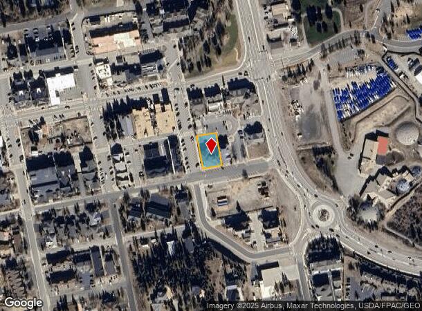
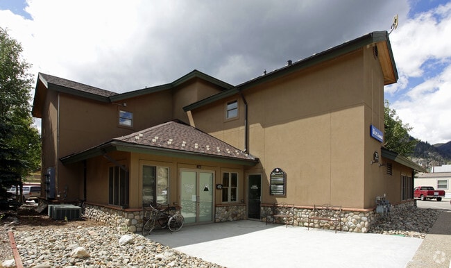
Property Record
701 Granite St, Frisco, CO 80443

Current Lease Availabilities
NEARBY LISTINGS FOR SALE OR LEASE
Property Detail
701 Granite St
Breckenridge, CO
Frisco Town Sub
1102663
LOT 13,14,15 BLOCK 13 FRISCO TOWN SUB
Commercialacreage
Summit
X
Colorado
08117C0354F
13
2023
0.24 AC
2024
Colorado Ski Area
000302
Other Market Areas
7,114 SF
DEMOGRAPHICS near 701 Granite St
1 Mile
3 Mile
5 Mile
2024 Total Population
3,430
5,097
14,793
2029 Population
3,295
4,898
14,452
Pop Growth 2024-2029
(3.94%)
(3.90%)
(2.31%)
Average Age
42
41
40
2024 Total Households
1,515
2,263
6,135
HH Growth 2024-2029
(3.89%)
(3.80%)
(2.27%)
Median Household Inc
$93,494
$90,406
$98,788
Avg Household Size
2.00
2.10
2.30
2024 Avg HH Vehicles
2.00
2.00
2.00
Median Home Value
$756,116
$709,039
$741,649
Median Year Built
1986
1986
1989
Nearby Places
Map Layers
Map Styles
 Street
 Aerial
- Restaurants
- Banks
- Shops
- Fitness
- Groceries
Nearby Properties
Address
Land Use
TOTAL SIZE
Lot Size
Zoning
Address
Land Use
TOTAL SIZE
Lot Size
Zoning
31,068 SF
3.79 AC
Address
Land Use
TOTAL SIZE
Lot Size
Zoning
127,470 SF
4.43 AC
FGW
Address
Land Use
TOTAL SIZE
Lot Size
Zoning
83,981 SF
2.99 AC
FGW
Address
Land Use
TOTAL SIZE
Lot Size
Zoning
32,423 SF
FGW
Address
Land Use
TOTAL SIZE
Lot Size
Zoning
74,964 SF
5.60 AC
CO
Address
Land Use
TOTAL SIZE
Lot Size
Zoning
4,932 SF
0.56 AC
CC
Address
Land Use
TOTAL SIZE
Lot Size
Zoning
15,620 SF
1.60 AC
CO
Address
Land Use
TOTAL SIZE
Lot Size
Zoning
14,403 SF
FGW
Address
Land Use
TOTAL SIZE
Lot Size
Zoning
21,894 SF
FGW
Address
Land Use
TOTAL SIZE
Lot Size
Zoning
15,441 SF
1.07 AC
PUD
Address
Land Use
TOTAL SIZE
Lot Size
Zoning
10,412 SF
11.54 AC
PUD
Address
Land Use
TOTAL SIZE
Lot Size
Zoning
20,200 SF
1.29 AC
PUD
Address
Land Use
TOTAL SIZE
Lot Size
Zoning
3.80 AC
FLI
Address
Land Use
TOTAL SIZE
Lot Size
Zoning
9,896 SF
4.05 AC
PUD
Address
Land Use
TOTAL SIZE
Lot Size
Zoning
2,460 SF
2.48 AC
FLI
Address
Land Use
TOTAL SIZE
Lot Size
Zoning
1 AC
MU
Address
Land Use
TOTAL SIZE
Lot Size
Zoning
46,899 SF
2.72 AC
CO
Address
Land Use
TOTAL SIZE
Lot Size
Zoning
8,547 SF
4.05 AC
PUD
Address
Land Use
TOTAL SIZE
Lot Size
Zoning
0.97 AC
FGW
Address
Land Use
TOTAL SIZE
Lot Size
Zoning
15,402 SF
FGW
Address
Land Use
TOTAL SIZE
Lot Size
Zoning
54,915 SF
1.98 AC
PUD
Address
Land Use
TOTAL SIZE
Lot Size
Zoning
20,402 SF
0.94 AC
FLI
Address
Land Use
TOTAL SIZE
Lot Size
Zoning
8,875 SF
FGW
Address
Land Use
TOTAL SIZE
Lot Size
Zoning
14,069 SF
0.12 AC
MU
Address
Land Use
TOTAL SIZE
Lot Size
Zoning
7,501 SF
0.95 AC
PUD
Address
Land Use
TOTAL SIZE
Lot Size
Zoning
8,879 SF
0.24 AC
CC
Address
Land Use
TOTAL SIZE
Lot Size
Zoning
12,213 SF
0.48 AC
CC
Address
Land Use
TOTAL SIZE
Lot Size
Zoning
1,865 SF
0.03 AC
PUD
Address
Land Use
TOTAL SIZE
Lot Size
Zoning
5,203 SF
1.02 AC
FGW
Address
Land Use
TOTAL SIZE
Lot Size
Zoning
967 SF
0.24 AC
RH
The World's #1 Commercial Real Estate Marketplace
Connect with us
© 2026 CoStar Group
The information above has been obtained from sources believed reliable. While we do not doubt its accuracy we have not verified it and make no guarantee, warranty or representation about it. It is your responsibility to independently confirm its accuracy and completeness. Any projections, opinions, assumptions, or estimates used are for example only and do not represent the current or future performance of the property. The value of this transaction to you depends on tax and other factors which should be evaluated by your tax, financial, and legal advisors. You and your advisors should conduct a careful, independent investigation of the property to determine to your satisfaction the suitability of the property for your needs.