Property Record
701 Highway 352, Mesquite, TX 75149

Current Lease Availabilities
NEARBY LISTINGS FOR SALE OR LEASE
Property Detail
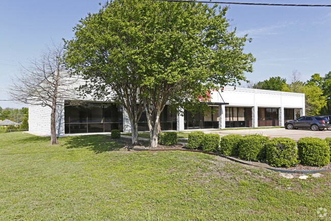
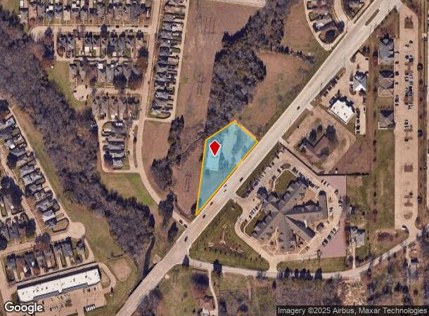
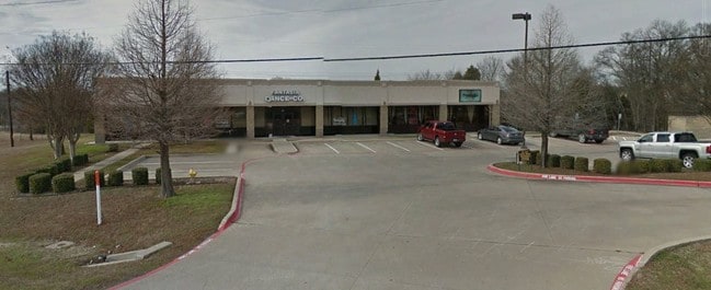
701 Highway 352
Dallas-Fort Worth-Arlington, TX
Samuel Park Farms Retail
381723000A0010000
SAMUEL PARK FARMS RETAIL BLK A LT 1 ACS 1.2307 INT201700257933 DD09122017 CO-DC 1723000A00100 3CM1723000A
Stripcommercialcenter
Dallas
X
Texas
48257C0025E
1
2024
1.23 AC
2025
Mesquite
018158
Dallas/Ft Worth
6,000 SF
DEMOGRAPHICS near 701 Highway 352
1 Mile
3 Mile
5 Mile
2024 Total Population
7,207
64,936
173,289
2029 Population
7,030
63,893
171,298
Pop Growth 2024-2029
(2.46%)
(1.61%)
(1.15%)
Average Age
36
37
35
2024 Total Households
2,272
20,891
55,488
HH Growth 2024-2029
(2.82%)
(1.94%)
(1.43%)
Median Household Inc
$66,944
$70,131
$63,243
Avg Household Size
3.10
3.00
3.00
2024 Avg HH Vehicles
2.00
2.00
2.00
Median Home Value
$188,111
$216,424
$202,374
Median Year Built
1985
1985
1984
Nearby Places
Map Layers
Map Styles
 Street
 Aerial
- Restaurants
- Banks
- Shops
- Fitness
- Groceries
PUBLIC TRANSPORTATION
AIRPORT
Dallas Love Field
DRIVE
WALK
Distance
Dallas Love Field
32 min
20.1 mi
Dallas-Fort Worth International
DRIVE
WALK
Distance
Dallas-Fort Worth International
47 min
39.1 mi
Nearby Properties
Address
Land Use
TOTAL SIZE
Lot Size
Zoning
Address
Land Use
TOTAL SIZE
Lot Size
Zoning
256,600 SF
80.73 AC
Z265
Address
Land Use
TOTAL SIZE
Lot Size
Zoning
877,230 SF
102.36 AC
Z05
Address
Land Use
TOTAL SIZE
Lot Size
Zoning
649,398 SF
42.19 AC
Address
Land Use
TOTAL SIZE
Lot Size
Zoning
592,958 SF
32.34 AC
Address
Land Use
TOTAL SIZE
Lot Size
Zoning
643,200 SF
30.02 AC
Z109
Address
Land Use
TOTAL SIZE
Lot Size
Zoning
144,858 SF
9.69 AC
Z206
Address
Land Use
TOTAL SIZE
Lot Size
Zoning
296,370 SF
17.15 AC
Z16
Address
Land Use
TOTAL SIZE
Lot Size
Zoning
255,008 SF
30.39 AC
Z250
Address
Land Use
TOTAL SIZE
Lot Size
Zoning
100 SF
0.01 AC
Z268
Address
Land Use
TOTAL SIZE
Lot Size
Zoning
1,229,138 SF
115.08 AC
Z117
Address
Land Use
TOTAL SIZE
Lot Size
Zoning
622,615 SF
35 AC
Z104
Address
Land Use
TOTAL SIZE
Lot Size
Zoning
223,216 SF
17.17 AC
Z31
Address
Land Use
TOTAL SIZE
Lot Size
Zoning
638,400 SF
40.70 AC
Z109
Address
Land Use
TOTAL SIZE
Lot Size
Zoning
214,853 SF
6.60 AC
Z372
Address
Land Use
TOTAL SIZE
Lot Size
Zoning
87,104 SF
18.31 AC
Z87
Address
Land Use
TOTAL SIZE
Lot Size
Zoning
407,195 SF
31.32 AC
Z109
Address
Land Use
TOTAL SIZE
Lot Size
Zoning
379,619 SF
24.68 AC
Z376
Address
Land Use
TOTAL SIZE
Lot Size
Zoning
320,390 SF
21.50 AC
Z267
Address
Land Use
TOTAL SIZE
Lot Size
Zoning
298,150 SF
20.01 AC
Z14
Address
Land Use
TOTAL SIZE
Lot Size
Zoning
349,440 SF
20.07 AC
Z104
Address
Land Use
TOTAL SIZE
Lot Size
Zoning
333,000 SF
17.04 AC
Address
Land Use
TOTAL SIZE
Lot Size
Zoning
217,606 SF
10.01 AC
Z237
Address
Land Use
TOTAL SIZE
Lot Size
Zoning
295,916 SF
16.52 AC
Z104
Address
Land Use
TOTAL SIZE
Lot Size
Zoning
241,512 SF
12.61 AC
Address
Land Use
TOTAL SIZE
Lot Size
Zoning
310,900 SF
18.01 AC
Address
Land Use
TOTAL SIZE
Lot Size
Zoning
107,376 SF
38.55 AC
Z372
Address
Land Use
TOTAL SIZE
Lot Size
Zoning
174,200 SF
1 AC
Z372
Address
Land Use
TOTAL SIZE
Lot Size
Zoning
110,668 SF
8.05 AC
Z372
Address
Land Use
TOTAL SIZE
Lot Size
Zoning
56,325 SF
3.84 AC
Z28
Address
Land Use
TOTAL SIZE
Lot Size
Zoning
197,526 SF
12 AC
Z237
The World's #1 Commercial Real Estate Marketplace
Connect with us
© 2026 CoStar Group
The information above has been obtained from sources believed reliable. While we do not doubt its accuracy we have not verified it and make no guarantee, warranty or representation about it. It is your responsibility to independently confirm its accuracy and completeness. Any projections, opinions, assumptions, or estimates used are for example only and do not represent the current or future performance of the property. The value of this transaction to you depends on tax and other factors which should be evaluated by your tax, financial, and legal advisors. You and your advisors should conduct a careful, independent investigation of the property to determine to your satisfaction the suitability of the property for your needs.