Property Record
701 N Webster St, Spring Hill, KS 66083
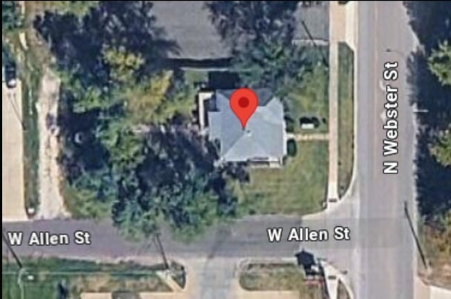
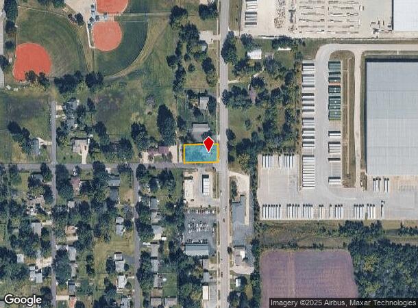
This Property Is For Sale
NEARBY LISTINGS FOR SALE OR LEASE
-
-
View all Spring Hill listings for sale on LoopNet.com
Property Detail
701 N Webster St
Kansas City, MO-KS
Spring Hill
EP10000012-0001
SPRING HILL LT 1 & S 20 LT 2 BLK 12 SPC 116
Sfr
Johnson
X
Kansas
20121C0055D
1,2
2024
0.28 AC
2024
Olathe
053801
Kansas City
1,104 SF
DEMOGRAPHICS near 701 N Webster St
1 mile
3 mile
5 mile
2024 Total Population
3,801
11,280
14,878
2029 Population
4,007
11,935
15,690
Pop Growth 2024-2029
+ 5.42%
+ 5.81%
+ 5.46%
Average Age
38
38
39
2024 Total Households
1,381
3,970
5,241
HH Growth 2024-2029
+ 5.58%
+ 6.02%
+ 5.63%
Median Household Inc
$103,343
$107,011
$106,899
Avg Household Size
2.70
2.80
2.80
2024 Avg HH Vehicles
2.00
2.00
2.00
Median Home Value
$328,803
$350,094
$367,681
Median Year Built
1990
2002
2001
Nearby Places
Map Layers
Map Styles
 Street
 Aerial
Transit
 Traffic
 Biking
Places
Listings with unknown addresses are not visible on the map
- Restaurants
- Banks
- Shops
- Fitness
- Groceries
Nearby Properties
Address
Land Use
TOTAL SIZE
Lot Size
Zoning
Address
Land Use
TOTAL SIZE
Lot Size
Zoning
327,169 SF
141.81 AC
R-R
Address
Land Use
TOTAL SIZE
Lot Size
Zoning
102,280 SF
30.53 AC
RP-4
Address
Land Use
TOTAL SIZE
Lot Size
Zoning
70,643 SF
18.45 AC
RP-1
Address
Land Use
TOTAL SIZE
Lot Size
Zoning
71,221 SF
14.16 AC
Address
Land Use
TOTAL SIZE
Lot Size
Zoning
97,479 SF
18.50 AC
R-1
Address
Land Use
TOTAL SIZE
Lot Size
Zoning
4,608 SF
45.43 AC
Address
Land Use
TOTAL SIZE
Lot Size
Zoning
62,610 SF
35.28 AC
R-1
Address
Land Use
TOTAL SIZE
Lot Size
Zoning
41,250 SF
6.01 AC
R-R
Address
Land Use
TOTAL SIZE
Lot Size
Zoning
476,083 SF
63.47 AC
M-1
Address
Land Use
TOTAL SIZE
Lot Size
Zoning
109,026 SF
11.21 AC
M-1
Address
Land Use
TOTAL SIZE
Lot Size
Zoning
24,622 SF
4.72 AC
R-1
Address
Land Use
TOTAL SIZE
Lot Size
Zoning
231,750 SF
22.02 AC
M-1
Address
Land Use
TOTAL SIZE
Lot Size
Zoning
39,800 SF
4.75 AC
M-1
Address
Land Use
TOTAL SIZE
Lot Size
Zoning
12,556 SF
2.60 AC
M-1
Address
Land Use
TOTAL SIZE
Lot Size
Zoning
15,210 SF
2.79 AC
C-2
Address
Land Use
TOTAL SIZE
Lot Size
Zoning
204,744 SF
13.37 AC
M-1
Address
Land Use
TOTAL SIZE
Lot Size
Zoning
4,112 SF
4.55 AC
Address
Land Use
TOTAL SIZE
Lot Size
Zoning
155.29 AC
CS
Address
Land Use
TOTAL SIZE
Lot Size
Zoning
168,500 SF
11.19 AC
M-1
Address
Land Use
TOTAL SIZE
Lot Size
Zoning
15,876 SF
6.49 AC
R-1
Address
Land Use
TOTAL SIZE
Lot Size
Zoning
20.31 AC
R-R
Address
Land Use
TOTAL SIZE
Lot Size
Zoning
12,112 SF
2 AC
R-1
Address
Land Use
TOTAL SIZE
Lot Size
Zoning
168,730 SF
15.32 AC
M-1
Address
Land Use
TOTAL SIZE
Lot Size
Zoning
8,744 SF
1.07 AC
R-1
Address
Land Use
TOTAL SIZE
Lot Size
Zoning
34,200 SF
6.24 AC
C-2
Address
Land Use
TOTAL SIZE
Lot Size
Zoning
47,685 SF
6.15 AC
Address
Land Use
TOTAL SIZE
Lot Size
Zoning
779 SF
5.60 AC
Address
Land Use
TOTAL SIZE
Lot Size
Zoning
8,400 SF
1.87 AC
R-1
Address
Land Use
TOTAL SIZE
Lot Size
Zoning
3,568 SF
0.29 AC
C-2
Address
Land Use
TOTAL SIZE
Lot Size
Zoning
12,048 SF
14 AC
M-1
The World's #1 Commercial Real Estate Marketplace
Connect with us
© 2026 CoStar Group
The information above has been obtained from sources believed reliable. While we do not doubt its accuracy we have not verified it and make no guarantee, warranty or representation about it. It is your responsibility to independently confirm its accuracy and completeness. Any projections, opinions, assumptions, or estimates used are for example only and do not represent the current or future performance of the property. The value of this transaction to you depends on tax and other factors which should be evaluated by your tax, financial, and legal advisors. You and your advisors should conduct a careful, independent investigation of the property to determine to your satisfaction the suitability of the property for your needs.