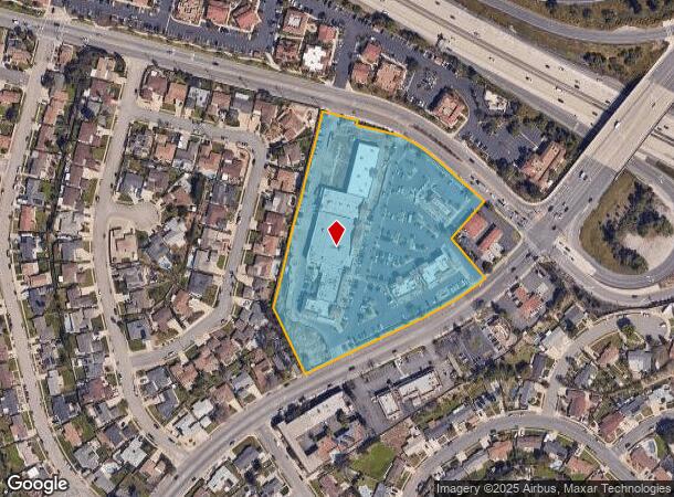
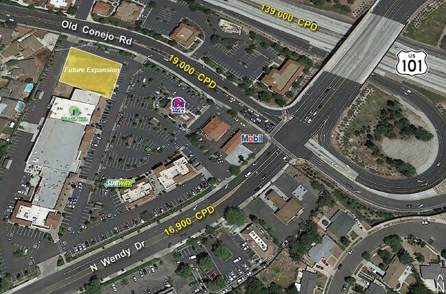
Property Record
701 N Wendy Dr, Newbury Park, CA 91320


NEARBY LISTINGS FOR SALE OR LEASE
-
-
View all Newbury Park listings for lease on LoopNet.com
Property Detail
701 N Wendy Dr
Oxnard-Thousand Oaks-Ventura, CA
1313
668-0-250-085
LOT: A REF: 001PM 095
Storebuilding
Ventura
X
California
06111C0954E
a
2025
6.88 AC
2025
Thousand Oaks/SE County
006000
Los Angeles
47,755 SF
DEMOGRAPHICS near 701 N Wendy Dr
1 Mile
3 Mile
5 Mile
2024 Total Population
7,825
47,264
107,355
2029 Population
7,682
46,498
105,759
Pop Growth 2024-2029
(1.83%)
(1.62%)
(1.49%)
Average Age
42
43
44
2024 Total Households
2,611
16,742
38,853
HH Growth 2024-2029
(1.99%)
(1.76%)
(1.57%)
Median Household Inc
$121,170
$126,404
$116,726
Avg Household Size
2.90
2.80
2.70
2024 Avg HH Vehicles
3.00
2.00
2.00
Median Home Value
$759,523
$809,180
$789,593
Median Year Built
1969
1978
1977
Nearby Places
Map Layers
Map Styles
 Street
 Aerial
- Restaurants
- Banks
- Shops
- Fitness
- Groceries
PUBLIC TRANSPORTATION
COMMUTER RAIL
Camarillo (Ventura County Line - Southern California Regional Rail Authority (Metrolink))
DRIVE
WALK
Distance
Camarillo (Ventura County Line - Southern California Regional Rail Authority (Metrolink))
10 min
6.9 mi
AIRPORT
Bob Hope
DRIVE
WALK
Distance
Bob Hope
51 min
39.0 mi
Los Angeles International
DRIVE
WALK
Distance
Los Angeles International
60 min
46.8 mi
Freight Ports
The Port of Hueneme
DRIVE
WALK
Distance
The Port of Hueneme
29 min
18.7 mi
SALE & LEASE HISTORY
LISTING DATE
SALE/LEASE

Sep 26, 2016
For Lease
Sep 25, 2016
For Lease
Oct 30, 2019
For Lease
Jul 25, 2018
For Lease
Nearby Properties
Address
Land Use
TOTAL SIZE
Lot Size
Zoning
Address
Land Use
TOTAL SIZE
Lot Size
Zoning
2.08 AC
Address
Land Use
TOTAL SIZE
Lot Size
Zoning
Address
Land Use
TOTAL SIZE
Lot Size
Zoning
Address
Land Use
TOTAL SIZE
Lot Size
Zoning
3.87 AC
Address
Land Use
TOTAL SIZE
Lot Size
Zoning
5.25 AC
Address
Land Use
TOTAL SIZE
Lot Size
Zoning
Address
Land Use
TOTAL SIZE
Lot Size
Zoning
98,667 SF
17.87 AC
Address
Land Use
TOTAL SIZE
Lot Size
Zoning
Address
Land Use
TOTAL SIZE
Lot Size
Zoning
49,559 SF
2.87 AC
M1
Address
Land Use
TOTAL SIZE
Lot Size
Zoning
1.94 AC
Address
Land Use
TOTAL SIZE
Lot Size
Zoning
2.07 AC
Address
Land Use
TOTAL SIZE
Lot Size
Zoning
164,951 SF
10.20 AC
RPD.
Address
Land Use
TOTAL SIZE
Lot Size
Zoning
3.15 AC
Address
Land Use
TOTAL SIZE
Lot Size
Zoning
74,757 SF
9.01 AC
Address
Land Use
TOTAL SIZE
Lot Size
Zoning
Address
Land Use
TOTAL SIZE
Lot Size
Zoning
Address
Land Use
TOTAL SIZE
Lot Size
Zoning
68,015 SF
1.22 AC
Address
Land Use
TOTAL SIZE
Lot Size
Zoning
Address
Land Use
TOTAL SIZE
Lot Size
Zoning
Address
Land Use
TOTAL SIZE
Lot Size
Zoning
1.50 AC
Address
Land Use
TOTAL SIZE
Lot Size
Zoning
200,980 SF
12.20 AC
Address
Land Use
TOTAL SIZE
Lot Size
Zoning
12,244 SF
77.34 AC
M1
Address
Land Use
TOTAL SIZE
Lot Size
Zoning
129,823 SF
8.30 AC
Address
Land Use
TOTAL SIZE
Lot Size
Zoning
11.60 AC
Address
Land Use
TOTAL SIZE
Lot Size
Zoning
129,242 SF
5.57 AC
Address
Land Use
TOTAL SIZE
Lot Size
Zoning
241,406 SF
14.10 AC
RPD.
Address
Land Use
TOTAL SIZE
Lot Size
Zoning
200,100 SF
11.38 AC
Address
Land Use
TOTAL SIZE
Lot Size
Zoning
38,304 SF
6.74 AC
M1
Address
Land Use
TOTAL SIZE
Lot Size
Zoning
54,869 SF
8.20 AC
Address
Land Use
TOTAL SIZE
Lot Size
Zoning
127,340 SF
8.13 AC
M1
The World's #1 Commercial Real Estate Marketplace
Connect with us
© 2025 CoStar Group
The information above has been obtained from sources believed reliable. While we do not doubt its accuracy we have not verified it and make no guarantee, warranty or representation about it. It is your responsibility to independently confirm its accuracy and completeness. Any projections, opinions, assumptions, or estimates used are for example only and do not represent the current or future performance of the property. The value of this transaction to you depends on tax and other factors which should be evaluated by your tax, financial, and legal advisors. You and your advisors should conduct a careful, independent investigation of the property to determine to your satisfaction the suitability of the property for your needs.