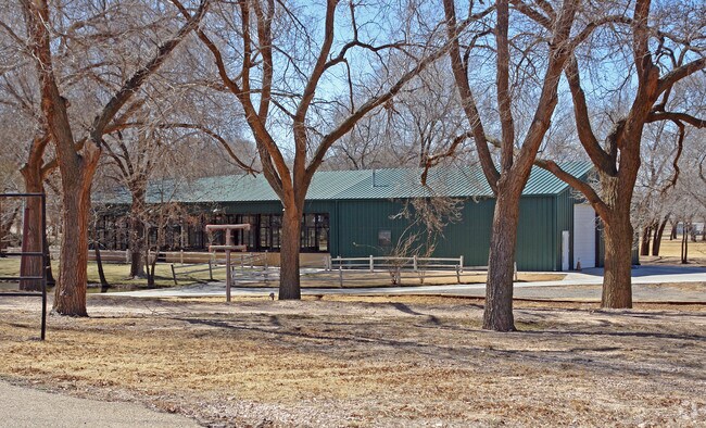
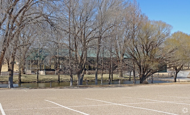
Property Record
701 Regis St, Lubbock, TX 79403

Property Detail
701 Regis St
Lubbock, TX
SPIRIT RANCH TR A
R67191
LUBBOCK
Restaurantbuilding
Texas
AE The base floodplain where base flood elevations are provided. AE Zones are now used on new format FIRMs instead of A1-A30 Zones.
270
2024
16.59 AC
2025
North Outer Lubbock
010201
Lubbock
13,762 SF
NEARBY LISTINGS FOR SALE OR LEASE
DEMOGRAPHICS near 701 Regis St
1 mile
3 mile
5 mile
2024 Total Population
683
5,262
50,179
2029 Population
728
5,604
51,990
Pop Growth 2024-2029
+ 6.59%
+ 6.50%
+ 3.61%
Average Age
39
39
33
2024 Total Households
247
1,903
16,786
HH Growth 2024-2029
+ 6.88%
+ 6.88%
+ 4.52%
Median Household Inc
$48,571
$50,256
$36,860
Avg Household Size
2.70
2.60
2.40
2024 Avg HH Vehicles
2.00
2.00
2.00
Median Home Value
$115,741
$149,708
$91,243
Median Year Built
1982
1989
1985
Nearby Places
Map Layers
Map Styles
 Street
 Aerial
Transit
 Traffic
 Biking
Places
Listings with unknown addresses are not visible on the map
- Restaurants
- Banks
- Shops
- Fitness
- Groceries
PUBLIC TRANSPORTATION
AIRPORT
Lubbock Preston Smith International
Drive
Walk
Distance
Lubbock Preston Smith International
16 min
7.1 mi
Nearby Properties
Address
Land Use
TOTAL SIZE
Lot Size
Zoning
Address
Land Use
TOTAL SIZE
Lot Size
Zoning
378,274 SF
53.07 AC
Address
Land Use
TOTAL SIZE
Lot Size
Zoning
281,520 SF
37.21 AC
Address
Land Use
TOTAL SIZE
Lot Size
Zoning
14.37 AC
Address
Land Use
TOTAL SIZE
Lot Size
Zoning
201,700 SF
16.98 AC
Address
Land Use
TOTAL SIZE
Lot Size
Zoning
202,925 SF
25.10 AC
Address
Land Use
TOTAL SIZE
Lot Size
Zoning
230,645 SF
36.48 AC
Address
Land Use
TOTAL SIZE
Lot Size
Zoning
160,000 SF
10.90 AC
Address
Land Use
TOTAL SIZE
Lot Size
Zoning
126,457 SF
6.96 AC
Address
Land Use
TOTAL SIZE
Lot Size
Zoning
105,097 SF
20.99 AC
Address
Land Use
TOTAL SIZE
Lot Size
Zoning
948,414 SF
92.10 AC
Address
Land Use
TOTAL SIZE
Lot Size
Zoning
126,881 SF
17.07 AC
Address
Land Use
TOTAL SIZE
Lot Size
Zoning
118,597 SF
22.67 AC
Address
Land Use
TOTAL SIZE
Lot Size
Zoning
138.71 AC
Address
Land Use
TOTAL SIZE
Lot Size
Zoning
77,400 SF
9.81 AC
Address
Land Use
TOTAL SIZE
Lot Size
Zoning
28,246 SF
3.84 AC
Address
Land Use
TOTAL SIZE
Lot Size
Zoning
638,799 SF
177.41 AC
Address
Land Use
TOTAL SIZE
Lot Size
Zoning
44,080 SF
12.20 AC
Address
Land Use
TOTAL SIZE
Lot Size
Zoning
195.61 AC
Address
Land Use
TOTAL SIZE
Lot Size
Zoning
302,000 SF
23.94 AC
Address
Land Use
TOTAL SIZE
Lot Size
Zoning
74,531 SF
156.55 AC
Address
Land Use
TOTAL SIZE
Lot Size
Zoning
14.05 AC
Address
Land Use
TOTAL SIZE
Lot Size
Zoning
159,397 SF
46.52 AC
Address
Land Use
TOTAL SIZE
Lot Size
Zoning
15,798 SF
11.84 AC
Address
Land Use
TOTAL SIZE
Lot Size
Zoning
29,840 SF
3.57 AC
Address
Land Use
TOTAL SIZE
Lot Size
Zoning
60,800 SF
10.99 AC
Address
Land Use
TOTAL SIZE
Lot Size
Zoning
45,000 SF
3.31 AC
Address
Land Use
TOTAL SIZE
Lot Size
Zoning
118.80 AC
Address
Land Use
TOTAL SIZE
Lot Size
Zoning
6,703 SF
3.10 AC
Address
Land Use
TOTAL SIZE
Lot Size
Zoning
113.82 AC
Address
Land Use
TOTAL SIZE
Lot Size
Zoning
28,866 SF
183.11 AC
The World's #1 Commercial Real Estate Marketplace
Connect with us
© 2026 CoStar Group
The information above has been obtained from sources believed reliable. While we do not doubt its accuracy we have not verified it and make no guarantee, warranty or representation about it. It is your responsibility to independently confirm its accuracy and completeness. Any projections, opinions, assumptions, or estimates used are for example only and do not represent the current or future performance of the property. The value of this transaction to you depends on tax and other factors which should be evaluated by your tax, financial, and legal advisors. You and your advisors should conduct a careful, independent investigation of the property to determine to your satisfaction the suitability of the property for your needs.