Property Record
7013 Expressway 83, Mission, TX 78572

Property Detail
7013 Expressway 83
McAllen-Edinburg-Mission, TX
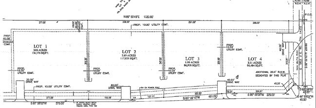
WANIS ENTERPRISES 3 LOT 3
W0754-03-000-0003-00
HIDALGO
Regionalshoppingcenterormallwithanchorstore
Texas
2024
3
2025
2.55 AC
023105
Outlying Hidalgo County
18,516 SF
McAllen/Edinburg/Pharr
NEARBY LISTINGS FOR SALE OR LEASE
DEMOGRAPHICS near 7013 Expressway 83
1 mile
3 mile
5 mile
2025 Total Population
1,736
20,735
43,455
2030 Population
1,833
21,810
45,843
Pop Growth 2025-2030
+ 5.59%
+ 5.18%
+ 5.50%
Average Age
34
35
37
2025 Total Households
472
6,222
13,495
HH Growth 2025-2030
+ 5.51%
+ 5.21%
+ 5.91%
Median Household Inc
$71,826
$40,768
$42,840
Avg Household Size
3.70
3.30
3.10
2025 Avg HH Vehicles
3.00
2.00
2.00
Median Home Value
$148,314
$123,898
$115,618
Median Year Built
1999
1986
1992
Nearby Places
Map Layers
Map Styles
 Street
 Aerial
Layers
 Traffic
 Biking
Places
Listings with unknown addresses are not visible on the map
- Restaurants
- Banks
- Shops
- Fitness
- Groceries
PUBLIC TRANSPORTATION
AIRPORT
Valley International
Drive
Walk
Distance
Valley International
36 min
20.0 mi
McAllen International
Drive
Walk
Distance
McAllen International
31 min
24.5 mi
Brownsville/South Padre Island International
Drive
Walk
Distance
Brownsville/South Padre Island International
52 min
40.6 mi
Freight Ports
Port of Brownsville
Drive
Walk
Distance
Port of Brownsville
45 min
38.3 mi
Nearby Properties
Address
Land Use
TOTAL SIZE
Lot Size
Zoning
Address
Land Use
TOTAL SIZE
Lot Size
Zoning
635,188 SF
80.14 AC
Address
Land Use
TOTAL SIZE
Lot Size
Zoning
160,873 SF
78.76 AC
Address
Land Use
TOTAL SIZE
Lot Size
Zoning
192,171 SF
16.56 AC
Address
Land Use
TOTAL SIZE
Lot Size
Zoning
74,470 SF
34 AC
Address
Land Use
TOTAL SIZE
Lot Size
Zoning
108,375 SF
1.82 AC
Address
Land Use
TOTAL SIZE
Lot Size
Zoning
40,170 SF
3.09 AC
Address
Land Use
TOTAL SIZE
Lot Size
Zoning
80,485 SF
11.67 AC
RM
Address
Land Use
TOTAL SIZE
Lot Size
Zoning
34,040 SF
16.86 AC
Address
Land Use
TOTAL SIZE
Lot Size
Zoning
11,812 SF
8.55 AC
Address
Land Use
TOTAL SIZE
Lot Size
Zoning
57,276 SF
7.13 AC
Address
Land Use
TOTAL SIZE
Lot Size
Zoning
38,592 SF
2.69 AC
Address
Land Use
TOTAL SIZE
Lot Size
Zoning
113,125 SF
19.93 AC
Address
Land Use
TOTAL SIZE
Lot Size
Zoning
7,920 SF
3.82 AC
CO
Address
Land Use
TOTAL SIZE
Lot Size
Zoning
17,912 SF
6.75 AC
Address
Land Use
TOTAL SIZE
Lot Size
Zoning
80,193 SF
6.46 AC
Address
Land Use
TOTAL SIZE
Lot Size
Zoning
725 SF
3.21 AC
Address
Land Use
TOTAL SIZE
Lot Size
Zoning
20,611 SF
5 AC
Address
Land Use
TOTAL SIZE
Lot Size
Zoning
41,149 SF
4.08 AC
Address
Land Use
TOTAL SIZE
Lot Size
Zoning
52,261 SF
3.46 AC
Address
Land Use
TOTAL SIZE
Lot Size
Zoning
13.47 AC
Address
Land Use
TOTAL SIZE
Lot Size
Zoning
30,244 SF
3.29 AC
Address
Land Use
TOTAL SIZE
Lot Size
Zoning
74,340 SF
4.06 AC
CO
Address
Land Use
TOTAL SIZE
Lot Size
Zoning
1 SF
27.82 AC
Address
Land Use
TOTAL SIZE
Lot Size
Zoning
17,695 SF
4.15 AC
C
Address
Land Use
TOTAL SIZE
Lot Size
Zoning
17,167 SF
1.11 AC
Address
Land Use
TOTAL SIZE
Lot Size
Zoning
26,832 SF
2.65 AC
Address
Land Use
TOTAL SIZE
Lot Size
Zoning
118,852 SF
10.33 AC
Address
Land Use
TOTAL SIZE
Lot Size
Zoning
15,097 SF
1.10 AC
Address
Land Use
TOTAL SIZE
Lot Size
Zoning
25,869 SF
3.62 AC
The World's #1 Commercial Real Estate Marketplace
Connect with us
© 2026 CoStar Group
The information above has been obtained from sources believed reliable. While we do not doubt its accuracy we have not verified it and make no guarantee, warranty or representation about it. It is your responsibility to independently confirm its accuracy and completeness. Any projections, opinions, assumptions, or estimates used are for example only and do not represent the current or future performance of the property. The value of this transaction to you depends on tax and other factors which should be evaluated by your tax, financial, and legal advisors. You and your advisors should conduct a careful, independent investigation of the property to determine to your satisfaction the suitability of the property for your needs.