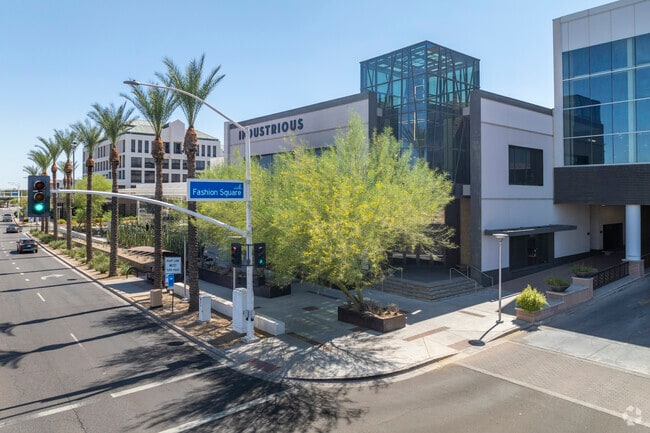
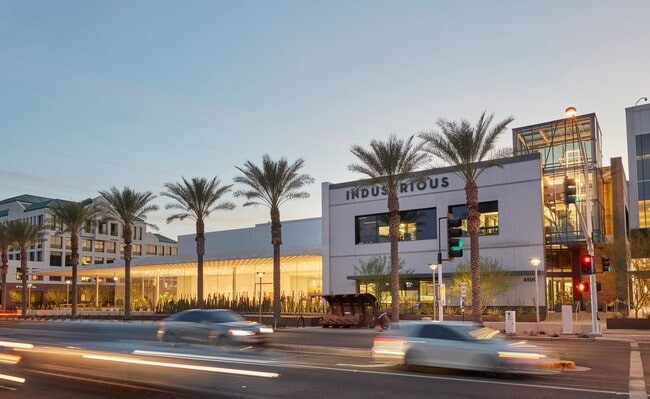
Property Record
6900 E Camelback Rd, Scottsdale, AZ 85251
Current Lease Availabilities
Property Detail
6900 E Camelback Rd
173-36-006R
ARCADIA VISTA UNIT 4 MCR 21/38
Regionalshoppingcenterormallwithanchorstore
MARICOPA
C-DT
Arizona
C and X Area of minimal flood hazard, usually depicted on FIRMs as above the 500-year flood level.
2
2025
10.13 AC
2025
Central Scottsdale
217300
Phoenix
839,134 SF
Phoenix-Mesa-Chandler, AZ
NEARBY LISTINGS FOR SALE OR LEASE
DEMOGRAPHICS near 6900 E Camelback Rd
1 mile
3 mile
5 mile
2025 Total Population
19,092
104,377
220,781
2030 Population
20,741
110,552
232,610
Pop Growth 2025-2030
+ 8.64%
+ 5.92%
+ 5.36%
Average Age
44
43
41
2025 Total Households
11,164
52,352
105,219
HH Growth 2025-2030
+ 8.74%
+ 6.13%
+ 5.54%
Median Household Inc
$96,492
$98,044
$91,317
Avg Household Size
1.70
1.90
2.00
2025 Avg HH Vehicles
1.00
2.00
2.00
Median Home Value
$723,232
$721,023
$732,178
Median Year Built
1993
1978
1978
Nearby Places
Map Layers
Map Styles
 Street
 Aerial
Transit
 Traffic
 Biking
Places
Listings with unknown addresses are not visible on the map
- Restaurants
- Banks
- Shops
- Fitness
- Groceries
PUBLIC TRANSPORTATION
AIRPORT
Phoenix Sky Harbor International
Drive
Walk
Distance
Phoenix Sky Harbor International
17 min
8.8 mi
Phoenix-Mesa Gateway
Drive
Walk
Distance
Phoenix-Mesa Gateway
42 min
29.1 mi
Freight Ports
Port of San Diego
Drive
Walk
Distance
Port of San Diego
410 min
365.5 mi
Nearby Properties
Address
Land Use
TOTAL SIZE
Lot Size
Zoning
Address
Land Use
TOTAL SIZE
Lot Size
Zoning
Address
Land Use
TOTAL SIZE
Lot Size
Zoning
2,636,740 SF
21.88 AC
C-DT
Address
Land Use
TOTAL SIZE
Lot Size
Zoning
33,483 SF
7.82 AC
PF
Address
Land Use
TOTAL SIZE
Lot Size
Zoning
1,457,213 SF
41.78 AC
PUD
Address
Land Use
TOTAL SIZE
Lot Size
Zoning
9,160 SF
2.57 AC
DDMU2
Address
Land Use
TOTAL SIZE
Lot Size
Zoning
981,325 SF
8.31 AC
Address
Land Use
TOTAL SIZE
Lot Size
Zoning
3.77 AC
PNC
Address
Land Use
TOTAL SIZE
Lot Size
Zoning
3,010 SF
35.44 AC
R110
Address
Land Use
TOTAL SIZE
Lot Size
Zoning
307,604 SF
37.83 AC
R-7
Address
Land Use
TOTAL SIZE
Lot Size
Zoning
776,898 SF
27.32 AC
C-R
Address
Land Use
TOTAL SIZE
Lot Size
Zoning
440,573 SF
19.10 AC
SUPR
Address
Land Use
TOTAL SIZE
Lot Size
Zoning
1,229,384 SF
4.81 AC
Address
Land Use
TOTAL SIZE
Lot Size
Zoning
517,502 SF
21.26 AC
SUPR
Address
Land Use
TOTAL SIZE
Lot Size
Zoning
457,979 SF
9.26 AC
CO
Address
Land Use
TOTAL SIZE
Lot Size
Zoning
392,172 SF
7.50 AC
DM2
Address
Land Use
TOTAL SIZE
Lot Size
Zoning
62,497 SF
130.73 AC
R-6
Address
Land Use
TOTAL SIZE
Lot Size
Zoning
439,600 SF
8.52 AC
DDCC2
Address
Land Use
TOTAL SIZE
Lot Size
Zoning
617,776 SF
4.53 AC
DDMU2
Address
Land Use
TOTAL SIZE
Lot Size
Zoning
22,630 SF
1.06 AC
SUPP
Address
Land Use
TOTAL SIZE
Lot Size
Zoning
282,287 SF
38.68 AC
R-10
Address
Land Use
TOTAL SIZE
Lot Size
Zoning
639,643 SF
5.43 AC
PAD
Address
Land Use
TOTAL SIZE
Lot Size
Zoning
289,633 SF
9.11 AC
R-10
Address
Land Use
TOTAL SIZE
Lot Size
Zoning
530,384 SF
5.24 AC
C-DT
Address
Land Use
TOTAL SIZE
Lot Size
Zoning
Address
Land Use
TOTAL SIZE
Lot Size
Zoning
590,903 SF
9.41 AC
C-DT
Address
Land Use
TOTAL SIZE
Lot Size
Zoning
438,373 SF
11.35 AC
Address
Land Use
TOTAL SIZE
Lot Size
Zoning
245,175 SF
6.94 AC
DDRU2
Address
Land Use
TOTAL SIZE
Lot Size
Zoning
1,137 SF
76.71 AC
RE35
Address
Land Use
TOTAL SIZE
Lot Size
Zoning
18,758 SF
312
Address
Land Use
TOTAL SIZE
Lot Size
Zoning
153,890 SF
8.54 AC
C-R
The World's #1 Commercial Real Estate Marketplace
Connect with us
© 2026 CoStar Group
The information above has been obtained from sources believed reliable. While we do not doubt its accuracy we have not verified it and make no guarantee, warranty or representation about it. It is your responsibility to independently confirm its accuracy and completeness. Any projections, opinions, assumptions, or estimates used are for example only and do not represent the current or future performance of the property. The value of this transaction to you depends on tax and other factors which should be evaluated by your tax, financial, and legal advisors. You and your advisors should conduct a careful, independent investigation of the property to determine to your satisfaction the suitability of the property for your needs.