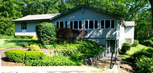
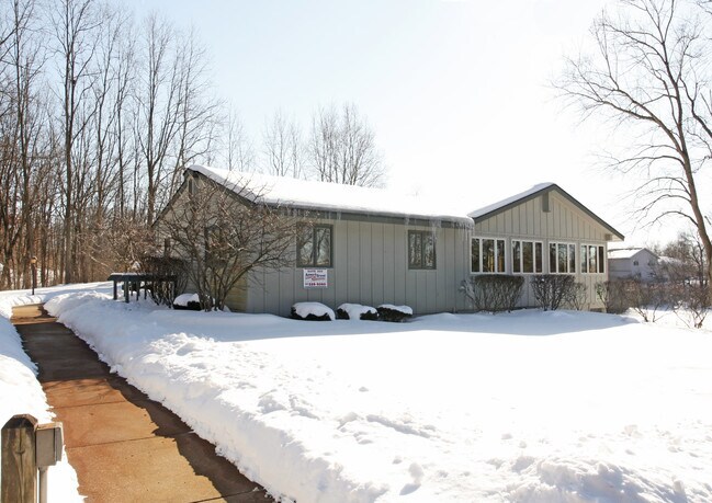
Property Record
7015 Fieldcrest Dr, Brighton, MI 48116
NEARBY LISTINGS FOR SALE OR LEASE
Property Detail
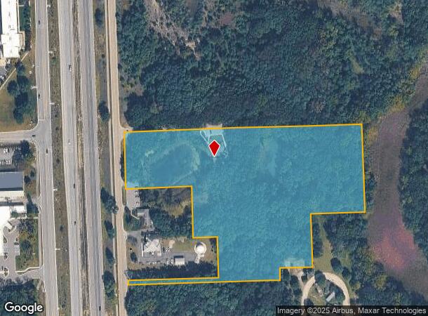
7015 Fieldcrest Dr
16-08-200-053
And Division
Commercialnec
PART OF THE WEST 1/2 OF THE NORTHEAST 1/4 OF SECTION 8, T1N-R6E, GREEN OAK TOWNSHIP, LIVINGSTON COUNTY, MICHIGAN, DESCRIBED
X
Livingston
26093C0345D
Michigan
2025
8.06 AC
2025
Livingston County
744200
Detroit
3,320 SF
Detroit-Warren-Dearborn, MI
DEMOGRAPHICS near 7015 Fieldcrest Dr
1 Mile
3 Mile
5 Mile
2024 Total Population
2,418
24,021
53,989
2029 Population
2,493
24,786
55,461
Pop Growth 2024-2029
+ 3.10%
+ 3.18%
+ 2.73%
Average Age
41
44
44
2024 Total Households
956
9,890
21,166
HH Growth 2024-2029
+ 3.03%
+ 3.24%
+ 2.79%
Median Household Inc
$97,262
$100,020
$101,805
Avg Household Size
2.50
2.40
2.50
2024 Avg HH Vehicles
2.00
2.00
2.00
Median Home Value
$261,219
$321,561
$341,767
Median Year Built
1970
1985
1986
Nearby Places
Map Layers
Map Styles
 Street
 Aerial
- Restaurants
- Banks
- Shops
- Fitness
- Groceries
PUBLIC TRANSPORTATION
AIRPORT
Bishop International
DRIVE
WALK
Distance
Bishop International
49 min
35.3 mi
Detroit Metro Wayne County
DRIVE
WALK
Distance
Detroit Metro Wayne County
55 min
44.3 mi
Nearby Properties
Address
Land Use
TOTAL SIZE
Lot Size
Zoning
Address
Land Use
TOTAL SIZE
Lot Size
Zoning
4.30 AC
R5
Address
Land Use
TOTAL SIZE
Lot Size
Zoning
136,172 SF
90.76 AC
PUD-VMU-2
Address
Land Use
TOTAL SIZE
Lot Size
Zoning
265,248 SF
59.38 AC
CD-RZ
Address
Land Use
TOTAL SIZE
Lot Size
Zoning
97,544 SF
12.13 AC
R4
Address
Land Use
TOTAL SIZE
Lot Size
Zoning
90,399 SF
13.90 AC
B-1
Address
Land Use
TOTAL SIZE
Lot Size
Zoning
114,371 SF
9.88 AC
R4
Address
Land Use
TOTAL SIZE
Lot Size
Zoning
85,147 SF
12.67 AC
C1
Address
Land Use
TOTAL SIZE
Lot Size
Zoning
13.40 AC
LI
Address
Land Use
TOTAL SIZE
Lot Size
Zoning
100,728 SF
14.30 AC
B-2
Address
Land Use
TOTAL SIZE
Lot Size
Zoning
100,326 SF
8.61 AC
R4
Address
Land Use
TOTAL SIZE
Lot Size
Zoning
57,169 SF
3.70 AC
OS
Address
Land Use
TOTAL SIZE
Lot Size
Zoning
6 AC
R4
Address
Land Use
TOTAL SIZE
Lot Size
Zoning
131,020 SF
11 AC
LI
Address
Land Use
TOTAL SIZE
Lot Size
Zoning
5 AC
R4
Address
Land Use
TOTAL SIZE
Lot Size
Zoning
146,030 SF
17.10 AC
LI
Address
Land Use
TOTAL SIZE
Lot Size
Zoning
173,345 SF
10.98 AC
LI
Address
Land Use
TOTAL SIZE
Lot Size
Zoning
82,704 SF
9.97 AC
LI
Address
Land Use
TOTAL SIZE
Lot Size
Zoning
141,438 SF
15.52 AC
PUD
Address
Land Use
TOTAL SIZE
Lot Size
Zoning
76,892 SF
5.42 AC
R4
Address
Land Use
TOTAL SIZE
Lot Size
Zoning
106,347 SF
11.47 AC
LI
Address
Land Use
TOTAL SIZE
Lot Size
Zoning
109,385 SF
17.19 AC
I-1
Address
Land Use
TOTAL SIZE
Lot Size
Zoning
44,849 SF
5.85 AC
C1
Address
Land Use
TOTAL SIZE
Lot Size
Zoning
83,785 SF
9.63 AC
CD-RZ
Address
Land Use
TOTAL SIZE
Lot Size
Zoning
43,758 SF
3.18 AC
B-3
Address
Land Use
TOTAL SIZE
Lot Size
Zoning
41,961 SF
4.88 AC
RA
Address
Land Use
TOTAL SIZE
Lot Size
Zoning
47,339 SF
9.56 AC
GI
Address
Land Use
TOTAL SIZE
Lot Size
Zoning
60,504 SF
3.15 AC
GB
Address
Land Use
TOTAL SIZE
Lot Size
Zoning
41,860 SF
22 AC
Address
Land Use
TOTAL SIZE
Lot Size
Zoning
32,600 SF
4.29 AC
OS
Address
Land Use
TOTAL SIZE
Lot Size
Zoning
91,510 SF
9.73 AC
GI
The World's #1 Commercial Real Estate Marketplace
Connect with us
© 2026 CoStar Group
The information above has been obtained from sources believed reliable. While we do not doubt its accuracy we have not verified it and make no guarantee, warranty or representation about it. It is your responsibility to independently confirm its accuracy and completeness. Any projections, opinions, assumptions, or estimates used are for example only and do not represent the current or future performance of the property. The value of this transaction to you depends on tax and other factors which should be evaluated by your tax, financial, and legal advisors. You and your advisors should conduct a careful, independent investigation of the property to determine to your satisfaction the suitability of the property for your needs.