Property Record
13990 E 71St St S, Derby, KS 67037
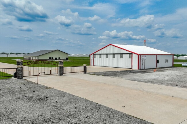

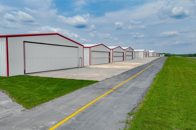
This Property Is For Sale
Property Detail
13990 E 71St St S
227-35-0-41-01-007.00
LOT 8 EXC N 217.85 FT & EXC TH PT COMM SE COR N 175 FT NELY 101.14 FT TH N ALG E LI 647.72 FT W 277.86 FT TO POB TH W 436 FT S 540 FT E 436 FT N 540 FT TO BEG & TH PT VAC ROAD ADJ ON S & E DESCRIBED IN DOC #29695850 BLOCK A DOWNWIND ESTATES ADDITION
Airport
SEDGWICK
RR
Kansas
A Areas with a 1% annual chance of flooding and a 26% chance of flooding over the life of a 30-year mortgage.
8
2024
23.74 AC
2025
Derby/Haysville/Mulvane
010007
Wichita
15,060 SF
Wichita, KS
NEARBY LISTINGS FOR SALE OR LEASE
-
-
View all Derby listings for sale on LoopNet.com
DEMOGRAPHICS near 13990 E 71St St S
1 mile
3 mile
5 mile
2025 Total Population
336
6,025
23,271
2030 Population
344
6,135
23,616
Pop Growth 2025-2030
+ 2.38%
+ 1.83%
+ 1.48%
Average Age
44
40
41
2025 Total Households
121
2,095
8,753
HH Growth 2025-2030
+ 2.48%
+ 1.86%
+ 1.17%
Median Household Inc
$119,886
$101,076
$96,126
Avg Household Size
2.70
2.80
2.60
2025 Avg HH Vehicles
3.00
3.00
2.00
Median Home Value
$325,000
$247,624
$267,884
Median Year Built
1993
1991
1996
Nearby Places
Map Layers
Map Styles
 Street
 Aerial
Layers
 Traffic
 Biking
Places
Listings with unknown addresses are not visible on the map
- Restaurants
- Banks
- Shops
- Fitness
- Groceries
PUBLIC TRANSPORTATION
AIRPORT
Wichita Dwight D Eisenhower Ntl
Drive
Walk
Distance
Wichita Dwight D Eisenhower Ntl
36 min
22.4 mi
Freight Ports
Tulsa Port Of Catoosa
Drive
Walk
Distance
Tulsa Port Of Catoosa
215 min
194.3 mi
Nearby Properties
Address
Land Use
TOTAL SIZE
Lot Size
Zoning
Address
Land Use
TOTAL SIZE
Lot Size
Zoning
97.20 AC
Address
Land Use
TOTAL SIZE
Lot Size
Zoning
279,330 SF
40.10 AC
Address
Land Use
TOTAL SIZE
Lot Size
Zoning
10,895 SF
2 AC
Address
Land Use
TOTAL SIZE
Lot Size
Zoning
13,318 SF
1.70 AC
Address
Land Use
TOTAL SIZE
Lot Size
Zoning
18,996 SF
5.30 AC
Address
Land Use
TOTAL SIZE
Lot Size
Zoning
15,186 SF
9.70 AC
Address
Land Use
TOTAL SIZE
Lot Size
Zoning
7,424 SF
3.80 AC
Address
Land Use
TOTAL SIZE
Lot Size
Zoning
6,554 SF
2.50 AC
Address
Land Use
TOTAL SIZE
Lot Size
Zoning
0.96 AC
Address
Land Use
TOTAL SIZE
Lot Size
Zoning
7,560 SF
1.80 AC
Address
Land Use
TOTAL SIZE
Lot Size
Zoning
61,650 SF
5 AC
Address
Land Use
TOTAL SIZE
Lot Size
Zoning
1,200 SF
21.40 AC
Address
Land Use
TOTAL SIZE
Lot Size
Zoning
4,923 SF
1 AC
Address
Land Use
TOTAL SIZE
Lot Size
Zoning
9,684 SF
0.43 AC
Address
Land Use
TOTAL SIZE
Lot Size
Zoning
11,918 SF
2 AC
Address
Land Use
TOTAL SIZE
Lot Size
Zoning
5,720 SF
0.73 AC
Address
Land Use
TOTAL SIZE
Lot Size
Zoning
20,264 SF
156.54 AC
RR
Address
Land Use
TOTAL SIZE
Lot Size
Zoning
17.10 AC
Address
Land Use
TOTAL SIZE
Lot Size
Zoning
33,718 SF
5.50 AC
Address
Land Use
TOTAL SIZE
Lot Size
Zoning
4,100 SF
1.10 AC
Address
Land Use
TOTAL SIZE
Lot Size
Zoning
12,100 SF
4.04 AC
RR
Address
Land Use
TOTAL SIZE
Lot Size
Zoning
2,520 SF
0.44 AC
Address
Land Use
TOTAL SIZE
Lot Size
Zoning
7,717 SF
3.64 AC
RR
Address
Land Use
TOTAL SIZE
Lot Size
Zoning
861 SF
1 AC
Address
Land Use
TOTAL SIZE
Lot Size
Zoning
11,014 SF
1.80 AC
Address
Land Use
TOTAL SIZE
Lot Size
Zoning
18.70 AC
Address
Land Use
TOTAL SIZE
Lot Size
Zoning
8,970 SF
1.10 AC
Address
Land Use
TOTAL SIZE
Lot Size
Zoning
12,646 SF
1.50 AC
Address
Land Use
TOTAL SIZE
Lot Size
Zoning
4,672 SF
0.64 AC
Address
Land Use
TOTAL SIZE
Lot Size
Zoning
7,200 SF
2.60 AC
The World's #1 Commercial Real Estate Marketplace
Connect with us
© 2026 CoStar Group
The information above has been obtained from sources believed reliable. While we do not doubt its accuracy we have not verified it and make no guarantee, warranty or representation about it. It is your responsibility to independently confirm its accuracy and completeness. Any projections, opinions, assumptions, or estimates used are for example only and do not represent the current or future performance of the property. The value of this transaction to you depends on tax and other factors which should be evaluated by your tax, financial, and legal advisors. You and your advisors should conduct a careful, independent investigation of the property to determine to your satisfaction the suitability of the property for your needs.