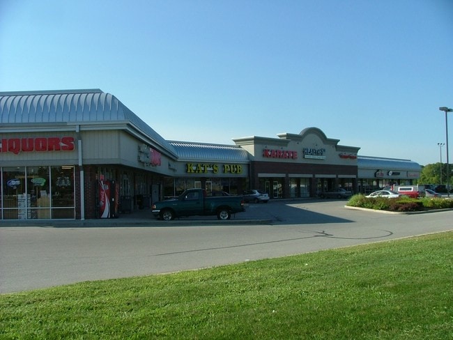
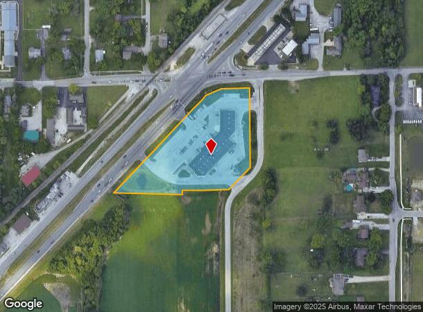
Property Record
7015 S Kentucky Ave, Camby, IN 46113
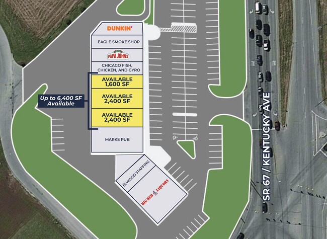
Current Lease Availabilities
NEARBY LISTINGS FOR SALE OR LEASE
-
-
View all Camby listings for lease on LoopNet.com
Property Detail
7015 S Kentucky Ave
49-13-16-117-005.000-200
PT NE1/4 NE1/4 S16 T14 R2 BEG 614.64 W & 47.18 S OF NE COR P.O.B. W123.53 SW73.33 SWRLY582 SE300.64 N18.15 E91.38 E110.05 NE133.11 N343.14 TO BEG 3.75AC
Regionalshoppingcenterormallwithanchorstore
Marion
X
Indiana
18097C0220F
3.76 AC
2023
Airport
2024
Indianapolis
370303
Indianapolis-Carmel-Greenwood, IN
25,069 SF
DEMOGRAPHICS near 7015 S Kentucky Ave
1 Mile
3 Mile
5 Mile
2024 Total Population
3,679
22,760
64,360
2029 Population
3,615
22,890
66,334
Pop Growth 2024-2029
(1.74%)
+ 0.57%
+ 3.07%
Average Age
35
36
38
2024 Total Households
1,274
8,034
24,027
HH Growth 2024-2029
(1.81%)
+ 0.72%
+ 3.28%
Median Household Inc
$70,807
$78,857
$71,591
Avg Household Size
2.70
2.80
2.60
2024 Avg HH Vehicles
2.00
2.00
2.00
Median Home Value
$185,745
$180,216
$183,722
Median Year Built
1995
1999
1991
Nearby Places
Map Layers
Map Styles
 Street
 Aerial
- Restaurants
- Banks
- Shops
- Fitness
- Groceries
PUBLIC TRANSPORTATION
AIRPORT
Indianapolis International
DRIVE
WALK
Distance
Indianapolis International
14 min
6.2 mi
Nearby Properties
Address
Land Use
TOTAL SIZE
Lot Size
Zoning
Address
Land Use
TOTAL SIZE
Lot Size
Zoning
911,062 SF
54.40 AC
ZO01
Address
Land Use
TOTAL SIZE
Lot Size
Zoning
41.50 AC
Address
Land Use
TOTAL SIZE
Lot Size
Zoning
822,500 SF
45.66 AC
Address
Land Use
TOTAL SIZE
Lot Size
Zoning
747,256 SF
41.32 AC
Address
Land Use
TOTAL SIZE
Lot Size
Zoning
665,724 SF
47.25 AC
ZO01
Address
Land Use
TOTAL SIZE
Lot Size
Zoning
798,160 SF
44.46 AC
ZO01
Address
Land Use
TOTAL SIZE
Lot Size
Zoning
997,763 SF
65.80 AC
ZO01
Address
Land Use
TOTAL SIZE
Lot Size
Zoning
650,960 SF
31.95 AC
Address
Land Use
TOTAL SIZE
Lot Size
Zoning
292,315 SF
28.97 AC
Address
Land Use
TOTAL SIZE
Lot Size
Zoning
595,100 SF
28.35 AC
Address
Land Use
TOTAL SIZE
Lot Size
Zoning
695,702 SF
39.68 AC
ZO03
Address
Land Use
TOTAL SIZE
Lot Size
Zoning
480,000 SF
40.60 AC
Address
Land Use
TOTAL SIZE
Lot Size
Zoning
462,275 SF
25.83 AC
ZO01
Address
Land Use
TOTAL SIZE
Lot Size
Zoning
442,201 SF
21.48 AC
Address
Land Use
TOTAL SIZE
Lot Size
Zoning
482,016 SF
26.70 AC
Address
Land Use
TOTAL SIZE
Lot Size
Zoning
426,088 SF
23.11 AC
Address
Land Use
TOTAL SIZE
Lot Size
Zoning
423,757 SF
28.71 AC
Address
Land Use
TOTAL SIZE
Lot Size
Zoning
465,480 SF
34.07 AC
Address
Land Use
TOTAL SIZE
Lot Size
Zoning
5,881 SF
17.35 AC
Address
Land Use
TOTAL SIZE
Lot Size
Zoning
23.17 AC
Address
Land Use
TOTAL SIZE
Lot Size
Zoning
442,215 SF
24.69 AC
Address
Land Use
TOTAL SIZE
Lot Size
Zoning
328,331 SF
39.63 AC
ZO01
Address
Land Use
TOTAL SIZE
Lot Size
Zoning
381,340 SF
15.72 AC
Address
Land Use
TOTAL SIZE
Lot Size
Zoning
440,198 SF
24.86 AC
Address
Land Use
TOTAL SIZE
Lot Size
Zoning
413,700 SF
16.97 AC
Address
Land Use
TOTAL SIZE
Lot Size
Zoning
380,155 SF
17.02 AC
Address
Land Use
TOTAL SIZE
Lot Size
Zoning
363,072 SF
25.08 AC
Address
Land Use
TOTAL SIZE
Lot Size
Zoning
346,808 SF
21.63 AC
Address
Land Use
TOTAL SIZE
Lot Size
Zoning
321,634 SF
18.58 AC
Address
Land Use
TOTAL SIZE
Lot Size
Zoning
11,404 SF
12.58 AC
The World's #1 Commercial Real Estate Marketplace
Connect with us
© 2026 CoStar Group
The information above has been obtained from sources believed reliable. While we do not doubt its accuracy we have not verified it and make no guarantee, warranty or representation about it. It is your responsibility to independently confirm its accuracy and completeness. Any projections, opinions, assumptions, or estimates used are for example only and do not represent the current or future performance of the property. The value of this transaction to you depends on tax and other factors which should be evaluated by your tax, financial, and legal advisors. You and your advisors should conduct a careful, independent investigation of the property to determine to your satisfaction the suitability of the property for your needs.