Property Record
7017 N Interstate 35, Georgetown, TX 78633

Property Detail
7017 N Interstate 35
Austin-Round Rock-San Marcos, TX
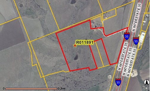
AW0421 AW0421 - MANCHACA, A. SUR., ACRES 49.22
R011891
WILLIAMSON
Agriculturalland
Texas
A Areas with a 1% annual chance of flooding and a 26% chance of flooding over the life of a 30-year mortgage.
49.22 AC
2024
Georgetown
2025
Austin
021603
NEARBY LISTINGS FOR SALE OR LEASE
DEMOGRAPHICS near 7017 N Interstate 35
1 mile
3 mile
5 mile
2024 Total Population
76
5,304
24,392
2029 Population
88
6,210
28,110
Pop Growth 2024-2029
+ 15.79%
+ 17.08%
+ 15.24%
Average Age
37
43
49
2024 Total Households
26
1,986
10,212
HH Growth 2024-2029
+ 15.38%
+ 17.52%
+ 15.26%
Median Household Inc
$59,999
$107,079
$98,063
Avg Household Size
2.70
2.60
2.40
2024 Avg HH Vehicles
3.00
2.00
2.00
Median Home Value
$428,571
$473,392
$459,691
Median Year Built
1999
2008
2005
Nearby Places
Map Layers
Map Styles
 Street
 Aerial
Transit
 Traffic
 Biking
Places
Listings with unknown addresses are not visible on the map
- Restaurants
- Banks
- Shops
- Fitness
- Groceries
PUBLIC TRANSPORTATION
AIRPORT
Robert Gray AAF
Drive
Walk
Distance
Robert Gray AAF
50 min
38.0 mi
Killeen Municipal
Drive
Walk
Distance
Killeen Municipal
48 min
38.7 mi
SALE & LEASE HISTORY
LISTING DATE
SALE/LEASE

Mar 06, 2017
For Sale
Feb 05, 2020
For Sale
Nearby Properties
Address
Land Use
TOTAL SIZE
Lot Size
Zoning
Address
Land Use
TOTAL SIZE
Lot Size
Zoning
495,945 SF
56.14 AC
Address
Land Use
TOTAL SIZE
Lot Size
Zoning
219,839 SF
24.74 AC
Address
Land Use
TOTAL SIZE
Lot Size
Zoning
22,936 SF
111.18 AC
Address
Land Use
TOTAL SIZE
Lot Size
Zoning
65,904 SF
14.96 AC
Address
Land Use
TOTAL SIZE
Lot Size
Zoning
101,484 SF
17.37 AC
Address
Land Use
TOTAL SIZE
Lot Size
Zoning
62,452 SF
11 AC
Address
Land Use
TOTAL SIZE
Lot Size
Zoning
39,020 SF
11.65 AC
Address
Land Use
TOTAL SIZE
Lot Size
Zoning
84,960 SF
5.12 AC
Address
Land Use
TOTAL SIZE
Lot Size
Zoning
31,480 SF
19.73 AC
Address
Land Use
TOTAL SIZE
Lot Size
Zoning
31,314 SF
34.41 AC
Address
Land Use
TOTAL SIZE
Lot Size
Zoning
11,200 SF
63.89 AC
Address
Land Use
TOTAL SIZE
Lot Size
Zoning
34,278 SF
4.98 AC
Address
Land Use
TOTAL SIZE
Lot Size
Zoning
45,764 SF
11.23 AC
Address
Land Use
TOTAL SIZE
Lot Size
Zoning
1,453 SF
360.07 AC
Address
Land Use
TOTAL SIZE
Lot Size
Zoning
56,950 SF
10 AC
Address
Land Use
TOTAL SIZE
Lot Size
Zoning
14,652 SF
18.54 AC
Address
Land Use
TOTAL SIZE
Lot Size
Zoning
18,001 SF
8.87 AC
Address
Land Use
TOTAL SIZE
Lot Size
Zoning
32,935 SF
10 AC
Address
Land Use
TOTAL SIZE
Lot Size
Zoning
7,968 SF
15.99 AC
Address
Land Use
TOTAL SIZE
Lot Size
Zoning
8,300 SF
1.81 AC
3-C-3
Address
Land Use
TOTAL SIZE
Lot Size
Zoning
11,100 SF
10 AC
Address
Land Use
TOTAL SIZE
Lot Size
Zoning
1,080 SF
10.01 AC
Address
Land Use
TOTAL SIZE
Lot Size
Zoning
5,460 SF
4.60 AC
Address
Land Use
TOTAL SIZE
Lot Size
Zoning
8,050 SF
2.13 AC
Address
Land Use
TOTAL SIZE
Lot Size
Zoning
89 SF
21.40 AC
Address
Land Use
TOTAL SIZE
Lot Size
Zoning
12,218 SF
9.92 AC
Address
Land Use
TOTAL SIZE
Lot Size
Zoning
19.03 AC
Address
Land Use
TOTAL SIZE
Lot Size
Zoning
32,000 SF
4.67 AC
Address
Land Use
TOTAL SIZE
Lot Size
Zoning
14,615 SF
2.62 AC
Address
Land Use
TOTAL SIZE
Lot Size
Zoning
1,200 SF
8.53 AC
The World's #1 Commercial Real Estate Marketplace
Connect with us
© 2026 CoStar Group
The information above has been obtained from sources believed reliable. While we do not doubt its accuracy we have not verified it and make no guarantee, warranty or representation about it. It is your responsibility to independently confirm its accuracy and completeness. Any projections, opinions, assumptions, or estimates used are for example only and do not represent the current or future performance of the property. The value of this transaction to you depends on tax and other factors which should be evaluated by your tax, financial, and legal advisors. You and your advisors should conduct a careful, independent investigation of the property to determine to your satisfaction the suitability of the property for your needs.