Property Record
702 149Th St, Whitestone, NY 11357
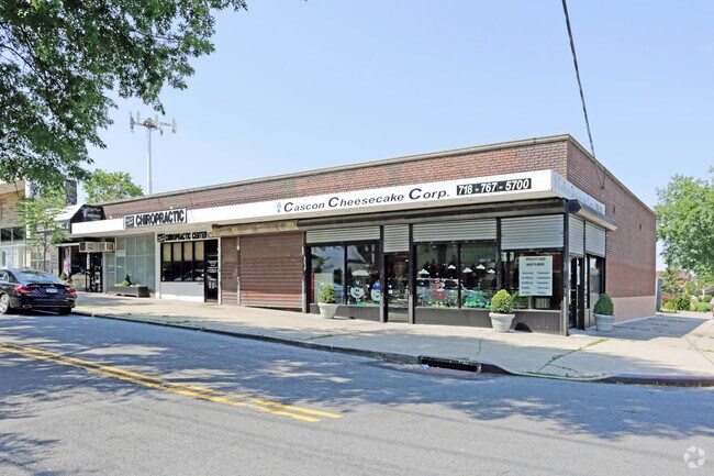

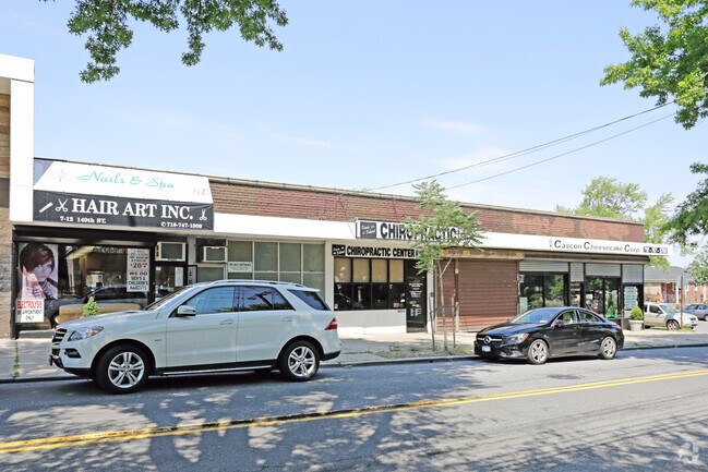
Property Detail
702 149Th St
04475-0047
Queens
Storebuilding
New York
R2A
47
B and X Area of moderate flood hazard, usually the area between the limits of the 100-year and 500-year floods.
0.57 AC
2024
Northeast Queens
2025
Long Island (New York)
097300
New York-Jersey City-White Plains, NY-NJ
16,700 SF
NEARBY LISTINGS FOR SALE OR LEASE
DEMOGRAPHICS near 702 149Th St
1 mile
3 mile
5 mile
2025 Total Population
21,607
330,544
1,292,830
2030 Population
21,087
325,007
1,266,349
Pop Growth 2025-2030
(2.41%)
(1.68%)
(2.05%)
Average Age
45
44
41
2025 Total Households
7,466
117,460
444,571
HH Growth 2025-2030
(2.92%)
(2.07%)
(2.37%)
Median Household Inc
$91,626
$67,856
$66,568
Avg Household Size
2.80
2.70
2.80
2025 Avg HH Vehicles
2.00
1.00
1.00
Median Home Value
$962,505
$709,485
$698,521
Median Year Built
1956
1959
1955
Nearby Places
Map Layers
Map Styles
 Street
 Aerial
Transit
 Traffic
 Biking
Places
Listings with unknown addresses are not visible on the map
- Restaurants
- Banks
- Shops
- Fitness
- Groceries
PUBLIC TRANSPORTATION
COMMUTER RAIL
Murray Hill Station (Port Washington Branch - Long Island Rail Road)
Drive
Walk
Distance
Murray Hill Station (Port Washington Branch - Long Island Rail Road)
7 min
2.3 mi
Broadway Station (Port Washington Branch - Long Island Rail Road)
Drive
Walk
Distance
Broadway Station (Port Washington Branch - Long Island Rail Road)
6 min
2.8 mi
AIRPORT
LaGuardia
Drive
Walk
Distance
LaGuardia
12 min
5.3 mi
John F Kennedy International
Drive
Walk
Distance
John F Kennedy International
18 min
12.9 mi
Newark Liberty International
Drive
Walk
Distance
Newark Liberty International
37 min
29.2 mi
Freight Ports
NY - Red Hook Container Terminal
Drive
Walk
Distance
NY - Red Hook Container Terminal
27 min
15.8 mi
Nearby Properties
Address
Land Use
TOTAL SIZE
Lot Size
Zoning
Address
Land Use
TOTAL SIZE
Lot Size
Zoning
1,012,000 SF
7.79 AC
R6
Address
Land Use
TOTAL SIZE
Lot Size
Zoning
703,265 SF
83.45 AC
R4
Address
Land Use
TOTAL SIZE
Lot Size
Zoning
421,996 SF
136.05 AC
R3-1
Address
Land Use
TOTAL SIZE
Lot Size
Zoning
4,050 SF
113.40 AC
PARK
Address
Land Use
TOTAL SIZE
Lot Size
Zoning
332,266 SF
12.57 AC
M2-1
Address
Land Use
TOTAL SIZE
Lot Size
Zoning
14,681 SF
97 AC
PARK
Address
Land Use
TOTAL SIZE
Lot Size
Zoning
489,326 SF
19.18 AC
C8-1
Address
Land Use
TOTAL SIZE
Lot Size
Zoning
510 SF
68.73 AC
PARK
Address
Land Use
TOTAL SIZE
Lot Size
Zoning
250,577 SF
23.17 AC
M2-1
Address
Land Use
TOTAL SIZE
Lot Size
Zoning
198,298 SF
13.93 AC
C4-1
Address
Land Use
TOTAL SIZE
Lot Size
Zoning
186,843 SF
5.37 AC
R2A
Address
Land Use
TOTAL SIZE
Lot Size
Zoning
281,416 SF
2.57 AC
C4-2
Address
Land Use
TOTAL SIZE
Lot Size
Zoning
674,889 SF
51.55 AC
M3-1
Address
Land Use
TOTAL SIZE
Lot Size
Zoning
382,302 SF
6.23 AC
R2A
Address
Land Use
TOTAL SIZE
Lot Size
Zoning
454,631 SF
24.61 AC
M1-1
Address
Land Use
TOTAL SIZE
Lot Size
Zoning
443,492 SF
27.75 AC
M1-1
Address
Land Use
TOTAL SIZE
Lot Size
Zoning
15.83 AC
M2-1
Address
Land Use
TOTAL SIZE
Lot Size
Zoning
202,063 SF
2.79 AC
C4-2
Address
Land Use
TOTAL SIZE
Lot Size
Zoning
1,172,800 SF
19.66 AC
R4
Address
Land Use
TOTAL SIZE
Lot Size
Zoning
164,110 SF
8.07 AC
M1-2
Address
Land Use
TOTAL SIZE
Lot Size
Zoning
109,805 SF
1.96 AC
C4-2
Address
Land Use
TOTAL SIZE
Lot Size
Zoning
239,223 SF
2.66 AC
R4
Address
Land Use
TOTAL SIZE
Lot Size
Zoning
303,039 SF
C4-2
Address
Land Use
TOTAL SIZE
Lot Size
Zoning
105,000 SF
0.85 AC
R5
Address
Land Use
TOTAL SIZE
Lot Size
Zoning
330,240 SF
13.62 AC
C4-1
Address
Land Use
TOTAL SIZE
Lot Size
Zoning
29,608 SF
33.60 AC
PARK
Address
Land Use
TOTAL SIZE
Lot Size
Zoning
1,021,752 SF
6.93 AC
R6
Address
Land Use
TOTAL SIZE
Lot Size
Zoning
426,224 SF
4.70 AC
R6
Address
Land Use
TOTAL SIZE
Lot Size
Zoning
375,810 SF
57.97 AC
M3-1
Address
Land Use
TOTAL SIZE
Lot Size
Zoning
170,000 SF
3.03 AC
R7-1
The World's #1 Commercial Real Estate Marketplace
Connect with us
© 2026 CoStar Group
The information above has been obtained from sources believed reliable. While we do not doubt its accuracy we have not verified it and make no guarantee, warranty or representation about it. It is your responsibility to independently confirm its accuracy and completeness. Any projections, opinions, assumptions, or estimates used are for example only and do not represent the current or future performance of the property. The value of this transaction to you depends on tax and other factors which should be evaluated by your tax, financial, and legal advisors. You and your advisors should conduct a careful, independent investigation of the property to determine to your satisfaction the suitability of the property for your needs.