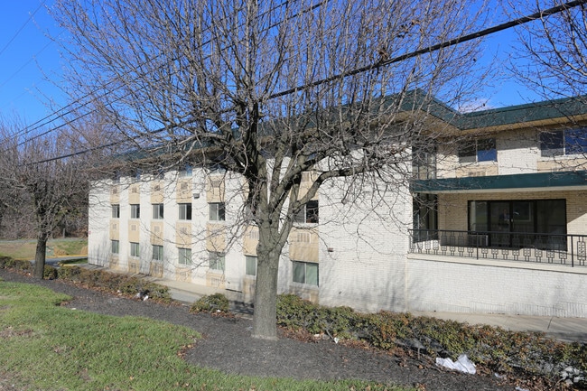
Property Record
702 E Gude Dr, Rockville, MD 20850


Current Lease Availabilities
NEARBY LISTINGS FOR SALE OR LEASE
Property Detail
702 E Gude Dr
04-00047427
Codm Spring Park Rockville Par Ind
Warehouse
PLAT 12688 PAR B COT LER INDUSTRIAL PARK
AE
Montgomery
51059C0075E
Maryland
2024
18.72 AC
2025
North Rockville
701211
Washington, DC
88,592 SF
Washington-Arlington-Alexandria, DC-VA-MD-WV
DEMOGRAPHICS near 702 E Gude Dr
1 Mile
3 Mile
5 Mile
2024 Total Population
3,936
89,009
317,144
2029 Population
3,856
88,089
313,814
Pop Growth 2024-2029
(2.03%)
(1.03%)
(1.05%)
Average Age
39
41
41
2024 Total Households
1,314
34,010
117,502
HH Growth 2024-2029
(2.44%)
(1.07%)
(1.06%)
Median Household Inc
$87,648
$115,605
$109,943
Avg Household Size
2.80
2.50
2.60
2024 Avg HH Vehicles
2.00
2.00
2.00
Median Home Value
$518,080
$620,074
$558,706
Median Year Built
1972
1979
1982
Nearby Places
Map Layers
Map Styles
 Street
 Aerial
- Restaurants
- Banks
- Shops
- Fitness
- Groceries
PUBLIC TRANSPORTATION
COMMUTER RAIL
Rockville (BRUNSWICK - WASHINGTON - Maryland Area Regional Commuter Trains (The MARC), Brunswick Line - Maryland Area Regional Commuter Trains (The MARC))
DRIVE
WALK
Distance
Rockville (BRUNSWICK - WASHINGTON - Maryland Area Regional Commuter Trains (The MARC), Brunswick Line - Maryland Area Regional Commuter Trains (The MARC))
5 min
1.7 mi
Washington Grove (BRUNSWICK - WASHINGTON - Maryland Area Regional Commuter Trains (The MARC), Brunswick Line - Maryland Area Regional Commuter Trains (The MARC))
DRIVE
WALK
Distance
Washington Grove (BRUNSWICK - WASHINGTON - Maryland Area Regional Commuter Trains (The MARC), Brunswick Line - Maryland Area Regional Commuter Trains (The MARC))
8 min
3.7 mi
AIRPORT
Ronald Reagan Washington Ntl
DRIVE
WALK
Distance
Ronald Reagan Washington Ntl
42 min
21.2 mi
Washington Dulles International
DRIVE
WALK
Distance
Washington Dulles International
49 min
29.3 mi
Baltimore/Washington International Thurgood Marshall
DRIVE
WALK
Distance
Baltimore/Washington International Thurgood Marshall
49 min
36.2 mi
Freight Ports
Port of Baltimore
DRIVE
WALK
Distance
Port of Baltimore
54 min
39.0 mi
Nearby Properties
Address
Land Use
TOTAL SIZE
Lot Size
Zoning
Address
Land Use
TOTAL SIZE
Lot Size
Zoning
987,382 SF
5 AC
MXTD
Address
Land Use
TOTAL SIZE
Lot Size
Zoning
713,627 SF
38.49 AC
LSC1.
Address
Land Use
TOTAL SIZE
Lot Size
Zoning
1,136,684 SF
84.61 AC
R200
Address
Land Use
TOTAL SIZE
Lot Size
Zoning
668,337 SF
10.39 AC
LSC1.
Address
Land Use
TOTAL SIZE
Lot Size
Zoning
978,527 SF
11.54 AC
03
Address
Land Use
TOTAL SIZE
Lot Size
Zoning
393,977 SF
17.88 AC
MXCD
Address
Land Use
TOTAL SIZE
Lot Size
Zoning
353,867 SF
11 AC
RS
Address
Land Use
TOTAL SIZE
Lot Size
Zoning
185,000 SF
2.60 AC
EOF
Address
Land Use
TOTAL SIZE
Lot Size
Zoning
434,440 SF
5.09 AC
CR1.5
Address
Land Use
TOTAL SIZE
Lot Size
Zoning
407,130 SF
4.62 AC
CRT1.
Address
Land Use
TOTAL SIZE
Lot Size
Zoning
302,484 SF
4.99 AC
MXD
Address
Land Use
TOTAL SIZE
Lot Size
Zoning
315,000 SF
4.70 AC
CR1.5
Address
Land Use
TOTAL SIZE
Lot Size
Zoning
363,000 SF
4.37 AC
MXTD
Address
Land Use
TOTAL SIZE
Lot Size
Zoning
405,742 SF
14.48 AC
R30
Address
Land Use
TOTAL SIZE
Lot Size
Zoning
243,000 SF
2.10 AC
PD-KS
Address
Land Use
TOTAL SIZE
Lot Size
Zoning
311,500 SF
29.05 AC
R60
Address
Land Use
TOTAL SIZE
Lot Size
Zoning
325,990 SF
51.21 AC
CRT07
Address
Land Use
TOTAL SIZE
Lot Size
Zoning
215,558 SF
13.74 AC
RS
Address
Land Use
TOTAL SIZE
Lot Size
Zoning
289,485 SF
9.82 AC
RS
Address
Land Use
TOTAL SIZE
Lot Size
Zoning
316,883 SF
8.62 AC
OCPD
Address
Land Use
TOTAL SIZE
Lot Size
Zoning
19.50 AC
MXCD
Address
Land Use
TOTAL SIZE
Lot Size
Zoning
172,740 SF
6.93 AC
PD-RC
Address
Land Use
TOTAL SIZE
Lot Size
Zoning
658,721 SF
4.90 AC
PD-UR
Address
Land Use
TOTAL SIZE
Lot Size
Zoning
230,460 SF
6.38 AC
03
Address
Land Use
TOTAL SIZE
Lot Size
Zoning
230,460 SF
6.36 AC
03
Address
Land Use
TOTAL SIZE
Lot Size
Zoning
167,000 SF
0.57 AC
MXNC
Address
Land Use
TOTAL SIZE
Lot Size
Zoning
316,973 SF
29.64 AC
R90
Address
Land Use
TOTAL SIZE
Lot Size
Zoning
192,356 SF
5.46 AC
MXE
Address
Land Use
TOTAL SIZE
Lot Size
Zoning
202,300 SF
4.01 AC
MXB
Address
Land Use
TOTAL SIZE
Lot Size
Zoning
658,721 SF
2.81 AC
PD-UR
The World's #1 Commercial Real Estate Marketplace
Connect with us
© 2025 CoStar Group
The information above has been obtained from sources believed reliable. While we do not doubt its accuracy we have not verified it and make no guarantee, warranty or representation about it. It is your responsibility to independently confirm its accuracy and completeness. Any projections, opinions, assumptions, or estimates used are for example only and do not represent the current or future performance of the property. The value of this transaction to you depends on tax and other factors which should be evaluated by your tax, financial, and legal advisors. You and your advisors should conduct a careful, independent investigation of the property to determine to your satisfaction the suitability of the property for your needs.