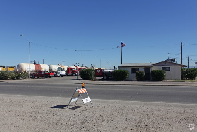
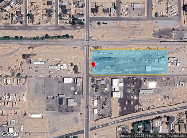
Property Record
702 N 4Th St, Buckeye, AZ 85326

NEARBY LISTINGS FOR SALE OR LEASE
-
-
View all Buckeye listings for sale on LoopNet.com
Property Detail
702 N 4Th St
400-18-970A
A POR NW4 SEC 5 1S 3W DAF COM N4 COR SD SEC TH W 495.56F TO A PT ON N LN TH S 85.02F TO TPOB TH CONT S 264.99F TO PT TH W 800.01F TO PT ELY R/W OF 4TH ST TH N 264.99F TO A PT LY 85.02F SLY OF N LN SD SEC 5 TH E 800.01F TO TPOB EX S 30F RD
Processingplant
Maricopa
AH
Arizona
04013C2115L
4.32 AC
2025
Goodyear
2025
Phoenix
050702
Phoenix-Mesa-Chandler, AZ
8,106 SF
DEMOGRAPHICS near 702 N 4Th St
1 Mile
3 Mile
5 Mile
2024 Total Population
9,042
27,679
46,020
2029 Population
9,844
30,181
50,287
Pop Growth 2024-2029
+ 8.87%
+ 9.04%
+ 9.27%
Average Age
35
33
34
2024 Total Households
2,908
8,234
13,699
HH Growth 2024-2029
+ 8.87%
+ 9.08%
+ 9.42%
Median Household Inc
$61,155
$67,960
$71,119
Avg Household Size
3.10
3.30
3.30
2024 Avg HH Vehicles
2.00
2.00
2.00
Median Home Value
$234,791
$259,586
$270,788
Median Year Built
1999
2005
2006
Nearby Places
Map Layers
Map Styles
 Street
 Aerial
- Restaurants
- Banks
- Shops
- Fitness
- Groceries
PUBLIC TRANSPORTATION
AIRPORT
Phoenix Sky Harbor International
DRIVE
WALK
Distance
Phoenix Sky Harbor International
53 min
40.4 mi
Nearby Properties
Address
Land Use
TOTAL SIZE
Lot Size
Zoning
Address
Land Use
TOTAL SIZE
Lot Size
Zoning
2,310,631 SF
215.58 AC
Address
Land Use
TOTAL SIZE
Lot Size
Zoning
1,207,360 SF
67.69 AC
Address
Land Use
TOTAL SIZE
Lot Size
Zoning
13.35 AC
Address
Land Use
TOTAL SIZE
Lot Size
Zoning
1,834,456 SF
142.44 AC
C-G
Address
Land Use
TOTAL SIZE
Lot Size
Zoning
11.14 AC
Address
Land Use
TOTAL SIZE
Lot Size
Zoning
3,494 SF
6.20 AC
GC
Address
Land Use
TOTAL SIZE
Lot Size
Zoning
510,427 SF
64.69 AC
GC
Address
Land Use
TOTAL SIZE
Lot Size
Zoning
290,752 SF
21.32 AC
SU
Address
Land Use
TOTAL SIZE
Lot Size
Zoning
269,665 SF
54.66 AC
PC
Address
Land Use
TOTAL SIZE
Lot Size
Zoning
93,337 SF
15.37 AC
PC
Address
Land Use
TOTAL SIZE
Lot Size
Zoning
78,774 SF
7.57 AC
PUD
Address
Land Use
TOTAL SIZE
Lot Size
Zoning
122,714 SF
12.27 AC
C-C
Address
Land Use
TOTAL SIZE
Lot Size
Zoning
68,255 SF
3.16 AC
PUD
Address
Land Use
TOTAL SIZE
Lot Size
Zoning
85,712 SF
15.18 AC
PR
Address
Land Use
TOTAL SIZE
Lot Size
Zoning
228,652 SF
136.91 AC
SU
Address
Land Use
TOTAL SIZE
Lot Size
Zoning
60,201 SF
14.10 AC
PUD
Address
Land Use
TOTAL SIZE
Lot Size
Zoning
125,120 SF
8.49 AC
SU
Address
Land Use
TOTAL SIZE
Lot Size
Zoning
181,308 SF
20.19 AC
C-G
Address
Land Use
TOTAL SIZE
Lot Size
Zoning
20,248 SF
23.16 AC
SU
Address
Land Use
TOTAL SIZE
Lot Size
Zoning
3.10 AC
Address
Land Use
TOTAL SIZE
Lot Size
Zoning
178,939 SF
13.98 AC
CC
Address
Land Use
TOTAL SIZE
Lot Size
Zoning
150,139 SF
20.48 AC
C-G
Address
Land Use
TOTAL SIZE
Lot Size
Zoning
136,836 SF
8.85 AC
R-R
Address
Land Use
TOTAL SIZE
Lot Size
Zoning
53.11 AC
C-G
Address
Land Use
TOTAL SIZE
Lot Size
Zoning
52,648 SF
10.15 AC
C-G
Address
Land Use
TOTAL SIZE
Lot Size
Zoning
40,859 SF
6.92 AC
PUD
Address
Land Use
TOTAL SIZE
Lot Size
Zoning
Address
Land Use
TOTAL SIZE
Lot Size
Zoning
24,119 SF
5.13 AC
CC
Address
Land Use
TOTAL SIZE
Lot Size
Zoning
32,567 SF
7.38 AC
PR
Address
Land Use
TOTAL SIZE
Lot Size
Zoning
16,502 SF
2.26 AC
C-C
The World's #1 Commercial Real Estate Marketplace
Connect with us
© 2026 CoStar Group
The information above has been obtained from sources believed reliable. While we do not doubt its accuracy we have not verified it and make no guarantee, warranty or representation about it. It is your responsibility to independently confirm its accuracy and completeness. Any projections, opinions, assumptions, or estimates used are for example only and do not represent the current or future performance of the property. The value of this transaction to you depends on tax and other factors which should be evaluated by your tax, financial, and legal advisors. You and your advisors should conduct a careful, independent investigation of the property to determine to your satisfaction the suitability of the property for your needs.