Property Record
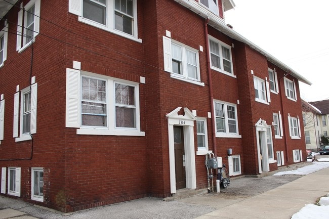
702 N Grant St, Bay City, MI 48708

Property Detail
702 N Grant St
09-160-021-481-003-00
LOT 11 BLK 26 H M BRADLEYS ADD TO BC
Commercialnec
Bay
RM-1 MED D
Michigan
B and X Area of moderate flood hazard, usually the area between the limits of the 100-year and 500-year floods.
11
2026
0.19 AC
2026
Midland/Flint
280600
Other Market Areas
2,599 SF
Bay City, MI
NEARBY LISTINGS FOR SALE OR LEASE
DEMOGRAPHICS near 702 N Grant St
1 mile
3 mile
5 mile
2025 Total Population
11,785
51,964
69,602
2030 Population
11,860
51,726
69,359
Pop Growth 2025-2030
+ 0.64%
(0.46%)
(0.35%)
Average Age
41
43
44
2025 Total Households
5,226
23,116
30,704
HH Growth 2025-2030
+ 0.65%
(0.44%)
(0.34%)
Median Household Inc
$43,349
$51,686
$54,327
Avg Household Size
2.10
2.20
2.20
2025 Avg HH Vehicles
1.00
2.00
2.00
Median Home Value
$99,366
$128,661
$144,497
Median Year Built
1947
1952
1956
Nearby Places
Map Layers
Map Styles
 Street
 Aerial
Layers
 Traffic
 Biking
Places
Listings with unknown addresses are not visible on the map
- Restaurants
- Banks
- Shops
- Fitness
- Groceries
PUBLIC TRANSPORTATION
AIRPORT
MBS International
Drive
Walk
Distance
MBS International
24 min
15.2 mi
Nearby Properties
Address
Land Use
TOTAL SIZE
Lot Size
Zoning
Address
Land Use
TOTAL SIZE
Lot Size
Zoning
97,304 SF
3.61 AC
C-3 CTRL B
Address
Land Use
TOTAL SIZE
Lot Size
Zoning
164,241 SF
10.08 AC
RM-1
Address
Land Use
TOTAL SIZE
Lot Size
Zoning
64,086 SF
6.78 AC
R-3
Address
Land Use
TOTAL SIZE
Lot Size
Zoning
163,673 SF
17.85 AC
RM-1
Address
Land Use
TOTAL SIZE
Lot Size
Zoning
16.52 AC
R-3
Address
Land Use
TOTAL SIZE
Lot Size
Zoning
169,440 SF
16.54 AC
RM-1
Address
Land Use
TOTAL SIZE
Lot Size
Zoning
536,802 SF
450 AC
I-2
Address
Land Use
TOTAL SIZE
Lot Size
Zoning
167,100 SF
35.59 AC
M-2 GEN IN
Address
Land Use
TOTAL SIZE
Lot Size
Zoning
279,395 SF
192 AC
I-2
Address
Land Use
TOTAL SIZE
Lot Size
Zoning
41,011 SF
8.28 AC
C-2
Address
Land Use
TOTAL SIZE
Lot Size
Zoning
60,200 SF
9.50 AC
C-3 CTRL B
Address
Land Use
TOTAL SIZE
Lot Size
Zoning
M-1 LT IND
Address
Land Use
TOTAL SIZE
Lot Size
Zoning
1.87 AC
C-3 CTRL B
Address
Land Use
TOTAL SIZE
Lot Size
Zoning
32,759 SF
1.20 AC
Address
Land Use
TOTAL SIZE
Lot Size
Zoning
57,000 SF
1.09 AC
C-3 CTRL B
Address
Land Use
TOTAL SIZE
Lot Size
Zoning
15.38 AC
M-1 LT IND
Address
Land Use
TOTAL SIZE
Lot Size
Zoning
50.79 AC
Address
Land Use
TOTAL SIZE
Lot Size
Zoning
50,965 SF
0.83 AC
C-3 CTRL B
Address
Land Use
TOTAL SIZE
Lot Size
Zoning
49,575 SF
4.77 AC
RM-1
Address
Land Use
TOTAL SIZE
Lot Size
Zoning
85,264 SF
5 AC
RM-1
Address
Land Use
TOTAL SIZE
Lot Size
Zoning
22,356 SF
I-2
Address
Land Use
TOTAL SIZE
Lot Size
Zoning
39,417 SF
0.23 AC
C-3 CTRL B
Address
Land Use
TOTAL SIZE
Lot Size
Zoning
63,200 SF
1.97 AC
C-3 CTRL B
Address
Land Use
TOTAL SIZE
Lot Size
Zoning
156,600 SF
9.11 AC
M-1 LT IND
Address
Land Use
TOTAL SIZE
Lot Size
Zoning
C-3 CTRL B
Address
Land Use
TOTAL SIZE
Lot Size
Zoning
Address
Land Use
TOTAL SIZE
Lot Size
Zoning
36,243 SF
3.41 AC
C-2
Address
Land Use
TOTAL SIZE
Lot Size
Zoning
45,072 SF
4.81 AC
C-2B HWY B
Address
Land Use
TOTAL SIZE
Lot Size
Zoning
109,649 SF
11.29 AC
C-2
Address
Land Use
TOTAL SIZE
Lot Size
Zoning
The World's #1 Commercial Real Estate Marketplace
Connect with us
© 2026 CoStar Group
The information above has been obtained from sources believed reliable. While we do not doubt its accuracy we have not verified it and make no guarantee, warranty or representation about it. It is your responsibility to independently confirm its accuracy and completeness. Any projections, opinions, assumptions, or estimates used are for example only and do not represent the current or future performance of the property. The value of this transaction to you depends on tax and other factors which should be evaluated by your tax, financial, and legal advisors. You and your advisors should conduct a careful, independent investigation of the property to determine to your satisfaction the suitability of the property for your needs.