Property Record
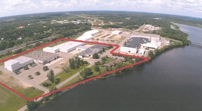
702 Paul Larson Memorial Dr, Little Falls, MN 56345

NEARBY LISTINGS FOR SALE OR LEASE
Property Detail
702 Paul Larson Memorial Dr
49.1220.000
PT OF GOV LOTS 2 & 3 SEC 17, LYING WLY OF CTRLN OF CAR 213 (COMMONLY KNOWN AS W RIVER RD) & LYING SLY OF SLY RT OF WA
Manufacturinglight
Morrison
X
Minnesota
27097C0576E
2-3
2025
10.59 AC
2025
Minnesota Central Area
780700
Other Market Areas
45,110 SF
DEMOGRAPHICS near 702 Paul Larson Memorial Dr
1 Mile
3 Mile
5 Mile
2024 Total Population
4,495
10,292
12,206
2029 Population
4,527
10,373
12,296
Pop Growth 2024-2029
+ 0.71%
+ 0.79%
+ 0.74%
Average Age
42
42
42
2024 Total Households
2,004
4,420
5,149
HH Growth 2024-2029
+ 0.70%
+ 0.72%
+ 0.70%
Median Household Inc
$44,535
$47,836
$51,546
Avg Household Size
2.10
2.20
2.30
2024 Avg HH Vehicles
2.00
2.00
2.00
Median Home Value
$158,727
$178,484
$190,436
Median Year Built
1958
1970
1972
Nearby Places
Map Layers
Map Styles
 Street
 Aerial
- Restaurants
- Banks
- Shops
- Fitness
- Groceries
SALE & LEASE HISTORY
LISTING DATE
SALE/LEASE

Sep 24, 2016
For Sale
Oct 05, 2016
For Sale
Mar 20, 2017
For Sale
Aug 08, 2017
For Sale
Nearby Properties
Address
Land Use
TOTAL SIZE
Lot Size
Zoning
Address
Land Use
TOTAL SIZE
Lot Size
Zoning
127,238 SF
68.32 AC
A
Address
Land Use
TOTAL SIZE
Lot Size
Zoning
13,814 SF
5.10 AC
A
Address
Land Use
TOTAL SIZE
Lot Size
Zoning
5,940 SF
2.38 AC
A
Address
Land Use
TOTAL SIZE
Lot Size
Zoning
36,320 SF
31.77 AC
A
Address
Land Use
TOTAL SIZE
Lot Size
Zoning
198,695 SF
22.48 AC
Address
Land Use
TOTAL SIZE
Lot Size
Zoning
63,000 SF
52.63 AC
A
Address
Land Use
TOTAL SIZE
Lot Size
Zoning
82,328 SF
5.07 AC
A
Address
Land Use
TOTAL SIZE
Lot Size
Zoning
81,735 SF
2.35 AC
A
Address
Land Use
TOTAL SIZE
Lot Size
Zoning
10,240 SF
13.53 AC
A
Address
Land Use
TOTAL SIZE
Lot Size
Zoning
87,865 SF
24.80 AC
Address
Land Use
TOTAL SIZE
Lot Size
Zoning
28,640 SF
8.77 AC
A
Address
Land Use
TOTAL SIZE
Lot Size
Zoning
67,480 SF
3.45 AC
A
Address
Land Use
TOTAL SIZE
Lot Size
Zoning
19,206 SF
5.33 AC
A
Address
Land Use
TOTAL SIZE
Lot Size
Zoning
64,944 SF
6.20 AC
Address
Land Use
TOTAL SIZE
Lot Size
Zoning
37,014 SF
Address
Land Use
TOTAL SIZE
Lot Size
Zoning
50,012 SF
A
Address
Land Use
TOTAL SIZE
Lot Size
Zoning
36,240 SF
10 AC
Address
Land Use
TOTAL SIZE
Lot Size
Zoning
2,340 SF
7.73 AC
A
Address
Land Use
TOTAL SIZE
Lot Size
Zoning
56,281 SF
17.10 AC
A
Address
Land Use
TOTAL SIZE
Lot Size
Zoning
90,588 SF
0.53 AC
A
Address
Land Use
TOTAL SIZE
Lot Size
Zoning
31,240 SF
2.38 AC
A
Address
Land Use
TOTAL SIZE
Lot Size
Zoning
21,289 SF
7.99 AC
Address
Land Use
TOTAL SIZE
Lot Size
Zoning
78,524 SF
3.89 AC
A
Address
Land Use
TOTAL SIZE
Lot Size
Zoning
51,953 SF
8.43 AC
A
Address
Land Use
TOTAL SIZE
Lot Size
Zoning
63,146 SF
2.86 AC
A
Address
Land Use
TOTAL SIZE
Lot Size
Zoning
23,264 SF
29.40 AC
A
Address
Land Use
TOTAL SIZE
Lot Size
Zoning
5,009 SF
8.75 AC
Address
Land Use
TOTAL SIZE
Lot Size
Zoning
9,256 SF
5.18 AC
A
Address
Land Use
TOTAL SIZE
Lot Size
Zoning
19,774 SF
2.54 AC
A
Address
Land Use
TOTAL SIZE
Lot Size
Zoning
52,108 SF
2.38 AC
A
The World's #1 Commercial Real Estate Marketplace
Connect with us
© 2026 CoStar Group
The information above has been obtained from sources believed reliable. While we do not doubt its accuracy we have not verified it and make no guarantee, warranty or representation about it. It is your responsibility to independently confirm its accuracy and completeness. Any projections, opinions, assumptions, or estimates used are for example only and do not represent the current or future performance of the property. The value of this transaction to you depends on tax and other factors which should be evaluated by your tax, financial, and legal advisors. You and your advisors should conduct a careful, independent investigation of the property to determine to your satisfaction the suitability of the property for your needs.