Property Record
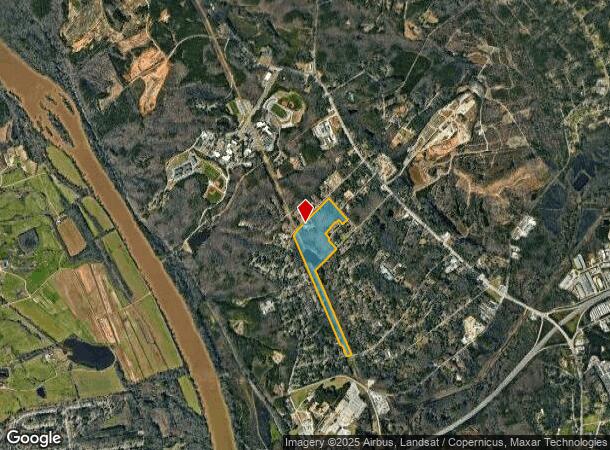
7020 Frost Ave, Columbia, SC 29203

NEARBY LISTINGS FOR SALE OR LEASE
-
-
View all Columbia listings for sale on LoopNet.com
Property Detail
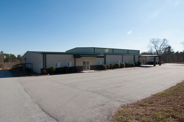
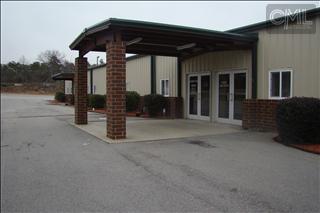
7020 Frost Ave
07614-02-01
TRACT J #SU FROST HEIGHTS #PR RB991-957 587-2771 G-150
Commercialnec
Richland
AE
South Carolina
45079C0229L
25.36 AC
2024
North Columbia
2023
Columbia
010501
Columbia, SC
16,441 SF
DEMOGRAPHICS near 7020 Frost Ave
1 Mile
3 Mile
5 Mile
2024 Total Population
1,779
36,711
106,277
2029 Population
1,800
37,290
109,635
Pop Growth 2024-2029
+ 1.18%
+ 1.58%
+ 3.16%
Average Age
37
38
39
2024 Total Households
742
14,930
46,392
HH Growth 2024-2029
+ 1.21%
+ 1.79%
+ 3.33%
Median Household Inc
$35,682
$39,440
$42,210
Avg Household Size
2.40
2.10
2.10
2024 Avg HH Vehicles
2.00
1.00
1.00
Median Home Value
$98,076
$108,766
$143,116
Median Year Built
1961
1973
1974
Nearby Places
Map Layers
Map Styles
 Street
 Aerial
- Restaurants
- Banks
- Shops
- Fitness
- Groceries
PUBLIC TRANSPORTATION
COMMUTER RAIL
DRIVE
WALK
Distance
17 min
7.1 mi
AIRPORT
Columbia Metro
DRIVE
WALK
Distance
Columbia Metro
30 min
16.4 mi
Nearby Properties
Address
Land Use
TOTAL SIZE
Lot Size
Zoning
Address
Land Use
TOTAL SIZE
Lot Size
Zoning
20,434 SF
17.20 AC
C-1
Address
Land Use
TOTAL SIZE
Lot Size
Zoning
128,877 SF
24.71 AC
RM-HD
Address
Land Use
TOTAL SIZE
Lot Size
Zoning
9,620 SF
18.91 AC
GC
Address
Land Use
TOTAL SIZE
Lot Size
Zoning
66,720 SF
19.20 AC
RM-2
Address
Land Use
TOTAL SIZE
Lot Size
Zoning
278,912 SF
23.24 AC
RM-HD
Address
Land Use
TOTAL SIZE
Lot Size
Zoning
232,600 SF
17.65 AC
RM-2
Address
Land Use
TOTAL SIZE
Lot Size
Zoning
207,112 SF
16.86 AC
RM-HD
Address
Land Use
TOTAL SIZE
Lot Size
Zoning
237,885 SF
20.76 AC
RM-2
Address
Land Use
TOTAL SIZE
Lot Size
Zoning
161,636 SF
12.38 AC
RM-HD
Address
Land Use
TOTAL SIZE
Lot Size
Zoning
208,688 SF
13.02 AC
RM-HD
Address
Land Use
TOTAL SIZE
Lot Size
Zoning
2,268 SF
27.70 AC
RM-1
Address
Land Use
TOTAL SIZE
Lot Size
Zoning
195,550 SF
17.19 AC
GC
Address
Land Use
TOTAL SIZE
Lot Size
Zoning
169,278 SF
12.21 AC
RM-HD
Address
Land Use
TOTAL SIZE
Lot Size
Zoning
153,272 SF
9.63 AC
RM-HD
Address
Land Use
TOTAL SIZE
Lot Size
Zoning
100 SF
465.41 AC
INS-GEN
Address
Land Use
TOTAL SIZE
Lot Size
Zoning
2,456 SF
5 AC
C-1
Address
Land Use
TOTAL SIZE
Lot Size
Zoning
192,966 SF
13.23 AC
RM-HD
Address
Land Use
TOTAL SIZE
Lot Size
Zoning
127,063 SF
14.70 AC
RM-HD
Address
Land Use
TOTAL SIZE
Lot Size
Zoning
204,968 SF
17.39 AC
RM-HD
Address
Land Use
TOTAL SIZE
Lot Size
Zoning
178,000 SF
11.71 AC
RM-1
Address
Land Use
TOTAL SIZE
Lot Size
Zoning
23,916 SF
4.43 AC
RG-2
Address
Land Use
TOTAL SIZE
Lot Size
Zoning
124,272 SF
7.06 AC
RM-HD
Address
Land Use
TOTAL SIZE
Lot Size
Zoning
63,842 SF
3.52 AC
C-3
Address
Land Use
TOTAL SIZE
Lot Size
Zoning
4,986 SF
5.74 AC
PUD-C
Address
Land Use
TOTAL SIZE
Lot Size
Zoning
307,287 SF
22.18 AC
RM-HD
Address
Land Use
TOTAL SIZE
Lot Size
Zoning
98,436 SF
14 AC
INS-GEN
Address
Land Use
TOTAL SIZE
Lot Size
Zoning
147,408 SF
17.49 AC
M-1
Address
Land Use
TOTAL SIZE
Lot Size
Zoning
141,468 SF
13.57 AC
RM-HD
Address
Land Use
TOTAL SIZE
Lot Size
Zoning
96,248 SF
5.97 AC
RM-2
Address
Land Use
TOTAL SIZE
Lot Size
Zoning
8,032 SF
3.20 AC
C-1
The World's #1 Commercial Real Estate Marketplace
Connect with us
© 2026 CoStar Group
The information above has been obtained from sources believed reliable. While we do not doubt its accuracy we have not verified it and make no guarantee, warranty or representation about it. It is your responsibility to independently confirm its accuracy and completeness. Any projections, opinions, assumptions, or estimates used are for example only and do not represent the current or future performance of the property. The value of this transaction to you depends on tax and other factors which should be evaluated by your tax, financial, and legal advisors. You and your advisors should conduct a careful, independent investigation of the property to determine to your satisfaction the suitability of the property for your needs.