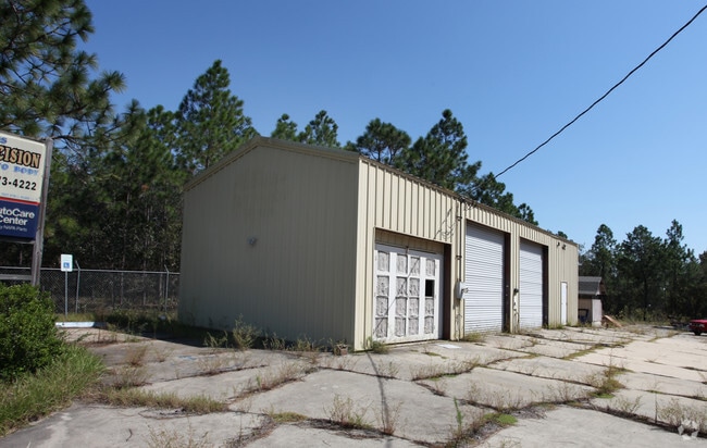
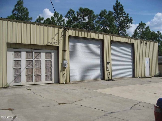
Property Record
7021 State Road 21, Keystone Heights, FL 32656

NEARBY LISTINGS FOR SALE OR LEASE
-
-
View all Keystone Heights listings for sale on LoopNet.com
Property Detail
7021 State Road 21
09-08-23-001039-002-12
PT OF SEC A/K/A LOT 6 AS REC OR 3946 PG 1283;3969 PG 1703;3970 PG 489 & 4104 PG 1495
Servicestation
Clay
X
Florida
12001C0220E
6
2024
0.98 AC
2025
Orange Park/Clay Cnty
031109
Jacksonville (Florida)
1,440 SF
Jacksonville, FL
DEMOGRAPHICS near 7021 State Road 21
1 Mile
3 Mile
5 Mile
2024 Total Population
1,052
9,772
16,764
2029 Population
1,171
10,793
18,383
Pop Growth 2024-2029
+ 11.31%
+ 10.45%
+ 9.66%
Average Age
42
43
43
2024 Total Households
404
3,793
6,626
HH Growth 2024-2029
+ 11.63%
+ 10.52%
+ 9.52%
Median Household Inc
$47,297
$51,305
$56,617
Avg Household Size
2.60
2.50
2.50
2024 Avg HH Vehicles
2.00
2.00
2.00
Median Home Value
$160,714
$182,848
$191,463
Median Year Built
1986
1985
1985
Nearby Places
Map Layers
Map Styles
 Street
 Aerial
- Restaurants
- Banks
- Shops
- Fitness
- Groceries
PUBLIC TRANSPORTATION
AIRPORT
Gainesville Regional
DRIVE
WALK
Distance
Gainesville Regional
41 min
25.0 mi
Freight Ports
Jacksonville Port
DRIVE
WALK
Distance
Jacksonville Port
78 min
53.4 mi
Nearby Properties
Address
Land Use
TOTAL SIZE
Lot Size
Zoning
Address
Land Use
TOTAL SIZE
Lot Size
Zoning
68,670 SF
10 AC
Address
Land Use
TOTAL SIZE
Lot Size
Zoning
116,370 SF
23.88 AC
PS-5
Address
Land Use
TOTAL SIZE
Lot Size
Zoning
52,626 SF
28.21 AC
Address
Land Use
TOTAL SIZE
Lot Size
Zoning
61,803 SF
18.29 AC
Address
Land Use
TOTAL SIZE
Lot Size
Zoning
60,351 SF
11.59 AC
Address
Land Use
TOTAL SIZE
Lot Size
Zoning
42,928 SF
4.69 AC
Address
Land Use
TOTAL SIZE
Lot Size
Zoning
26,203 SF
0.80 AC
Address
Land Use
TOTAL SIZE
Lot Size
Zoning
22,485 SF
110 AC
Address
Land Use
TOTAL SIZE
Lot Size
Zoning
36,867 SF
127 AC
Address
Land Use
TOTAL SIZE
Lot Size
Zoning
5,040 SF
980.37 AC
Address
Land Use
TOTAL SIZE
Lot Size
Zoning
30,198 SF
140 AC
Address
Land Use
TOTAL SIZE
Lot Size
Zoning
21,704 SF
8.45 AC
Address
Land Use
TOTAL SIZE
Lot Size
Zoning
14,736 SF
2.13 AC
Address
Land Use
TOTAL SIZE
Lot Size
Zoning
8,266 SF
1.20 AC
Address
Land Use
TOTAL SIZE
Lot Size
Zoning
13,000 SF
2.24 AC
RB
Address
Land Use
TOTAL SIZE
Lot Size
Zoning
10,115 SF
0.92 AC
PO-1
Address
Land Use
TOTAL SIZE
Lot Size
Zoning
Address
Land Use
TOTAL SIZE
Lot Size
Zoning
589.03 AC
Address
Land Use
TOTAL SIZE
Lot Size
Zoning
2,485 SF
2.43 AC
Address
Land Use
TOTAL SIZE
Lot Size
Zoning
4,625 SF
1.84 AC
Address
Land Use
TOTAL SIZE
Lot Size
Zoning
492.81 AC
Address
Land Use
TOTAL SIZE
Lot Size
Zoning
3,133 SF
1.65 AC
Address
Land Use
TOTAL SIZE
Lot Size
Zoning
7,532 SF
1.06 AC
Address
Land Use
TOTAL SIZE
Lot Size
Zoning
20,001 SF
1.47 AC
Address
Land Use
TOTAL SIZE
Lot Size
Zoning
415.10 AC
AR
Address
Land Use
TOTAL SIZE
Lot Size
Zoning
400.90 AC
Address
Land Use
TOTAL SIZE
Lot Size
Zoning
15,800 SF
2.47 AC
Address
Land Use
TOTAL SIZE
Lot Size
Zoning
1,782 SF
1.09 AC
Address
Land Use
TOTAL SIZE
Lot Size
Zoning
9,146 SF
1.52 AC
Address
Land Use
TOTAL SIZE
Lot Size
Zoning
7,360 SF
0.84 AC
The World's #1 Commercial Real Estate Marketplace
Connect with us
© 2026 CoStar Group
The information above has been obtained from sources believed reliable. While we do not doubt its accuracy we have not verified it and make no guarantee, warranty or representation about it. It is your responsibility to independently confirm its accuracy and completeness. Any projections, opinions, assumptions, or estimates used are for example only and do not represent the current or future performance of the property. The value of this transaction to you depends on tax and other factors which should be evaluated by your tax, financial, and legal advisors. You and your advisors should conduct a careful, independent investigation of the property to determine to your satisfaction the suitability of the property for your needs.