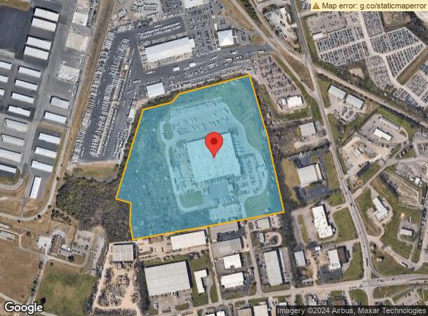
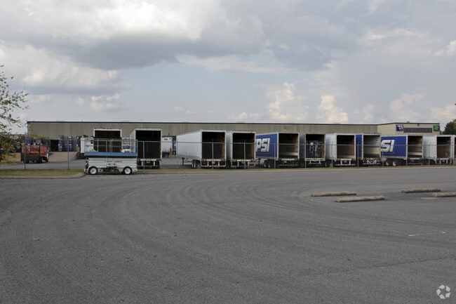
Property Record
7021 Westbelt Dr, Nashville, TN 37209

NEARBY LISTINGS FOR SALE OR LEASE
Property Detail
7021 Westbelt Dr
079-00-0-071
Cockrill Bend Ind
Commercialacreage
N OF COCKRILL BEND IND RD & W OF CENTENNIAL BV
X
Davidson
47037C0217H
Tennessee
2025
33.95 AC
2025
West
013001
Nashville
18,926 SF
Nashville-Davidson--Murfreesboro--Franklin, TN
DEMOGRAPHICS near 7021 Westbelt Dr
1 Mile
3 Mile
5 Mile
2024 Total Population
944
31,092
117,965
2029 Population
972
31,085
119,251
Pop Growth 2024-2029
+ 2.97%
(0.02%)
+ 1.09%
Average Age
35
36
37
2024 Total Households
405
12,997
53,716
HH Growth 2024-2029
+ 2.72%
(0.33%)
+ 1.20%
Median Household Inc
$71,249
$65,590
$64,093
Avg Household Size
2.20
2.20
2.00
2024 Avg HH Vehicles
2.00
2.00
2.00
Median Home Value
$362,083
$400,957
$455,675
Median Year Built
2010
1978
1992
Nearby Places
Map Layers
Map Styles
 Street
 Aerial
- Restaurants
- Banks
- Shops
- Fitness
- Groceries
PUBLIC TRANSPORTATION
COMMUTER RAIL
Riverfront (East Corridor Line - Tennessee Regional Transportation Authority Music City Star (Music City Star))
DRIVE
WALK
Distance
Riverfront (East Corridor Line - Tennessee Regional Transportation Authority Music City Star (Music City Star))
16 min
8.5 mi
AIRPORT
Nashville International
DRIVE
WALK
Distance
Nashville International
27 min
17.4 mi
Nearby Properties
Address
Land Use
TOTAL SIZE
Lot Size
Zoning
Address
Land Use
TOTAL SIZE
Lot Size
Zoning
301.19 AC
MULTI-ZONE
Address
Land Use
TOTAL SIZE
Lot Size
Zoning
20,496 SF
41.24 AC
RM20
Address
Land Use
TOTAL SIZE
Lot Size
Zoning
213,556 SF
123.31 AC
IR
Address
Land Use
TOTAL SIZE
Lot Size
Zoning
154,530 SF
6.18 AC
SP
Address
Land Use
TOTAL SIZE
Lot Size
Zoning
33,664 SF
18.98 AC
IWD
Address
Land Use
TOTAL SIZE
Lot Size
Zoning
89,821 SF
3.90 AC
IR
Address
Land Use
TOTAL SIZE
Lot Size
Zoning
146.13 AC
IR
Address
Land Use
TOTAL SIZE
Lot Size
Zoning
234,840 SF
3.25 AC
MULTIZONE
Address
Land Use
TOTAL SIZE
Lot Size
Zoning
2,768 SF
16.64 AC
RM9
Address
Land Use
TOTAL SIZE
Lot Size
Zoning
15,045 SF
7.10 AC
IR
Address
Land Use
TOTAL SIZE
Lot Size
Zoning
146,453 SF
3.42 AC
IR
Address
Land Use
TOTAL SIZE
Lot Size
Zoning
6,160 SF
12.53 AC
MULTI-ZONE
Address
Land Use
TOTAL SIZE
Lot Size
Zoning
76,395 SF
5.10 AC
MULA
Address
Land Use
TOTAL SIZE
Lot Size
Zoning
11,180 SF
3.06 AC
RS7.5
Address
Land Use
TOTAL SIZE
Lot Size
Zoning
52,769 SF
14.38 AC
SCR
Address
Land Use
TOTAL SIZE
Lot Size
Zoning
20,160 SF
15.30 AC
RM20
Address
Land Use
TOTAL SIZE
Lot Size
Zoning
7,022 SF
6.05 AC
CS
Address
Land Use
TOTAL SIZE
Lot Size
Zoning
140,940 SF
1.35 AC
CS
Address
Land Use
TOTAL SIZE
Lot Size
Zoning
58,613 SF
494.44 AC
MULTI-ZONE
Address
Land Use
TOTAL SIZE
Lot Size
Zoning
24,816 SF
19.13 AC
RM9
Address
Land Use
TOTAL SIZE
Lot Size
Zoning
18,210 SF
16.87 AC
R6
Address
Land Use
TOTAL SIZE
Lot Size
Zoning
7,600 SF
13.95 AC
RM20
Address
Land Use
TOTAL SIZE
Lot Size
Zoning
41,624 SF
6.61 AC
IR
Address
Land Use
TOTAL SIZE
Lot Size
Zoning
128,588 SF
1.80 AC
IR
Address
Land Use
TOTAL SIZE
Lot Size
Zoning
71,393 SF
9.07 AC
SCR
Address
Land Use
TOTAL SIZE
Lot Size
Zoning
66,720 SF
0.46 AC
SP
Address
Land Use
TOTAL SIZE
Lot Size
Zoning
30,456 SF
118.53 AC
IR
Address
Land Use
TOTAL SIZE
Lot Size
Zoning
28,660 SF
46.90 AC
IR
Address
Land Use
TOTAL SIZE
Lot Size
Zoning
61,019 SF
3.66 AC
MULTIZONE
Address
Land Use
TOTAL SIZE
Lot Size
Zoning
47,263 SF
7.54 AC
CS
The World's #1 Commercial Real Estate Marketplace
Connect with us
© 2026 CoStar Group
The information above has been obtained from sources believed reliable. While we do not doubt its accuracy we have not verified it and make no guarantee, warranty or representation about it. It is your responsibility to independently confirm its accuracy and completeness. Any projections, opinions, assumptions, or estimates used are for example only and do not represent the current or future performance of the property. The value of this transaction to you depends on tax and other factors which should be evaluated by your tax, financial, and legal advisors. You and your advisors should conduct a careful, independent investigation of the property to determine to your satisfaction the suitability of the property for your needs.