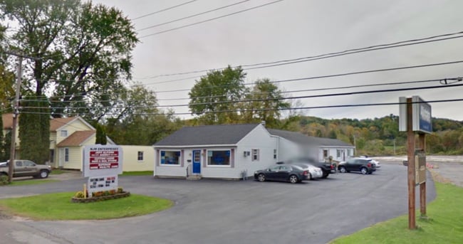
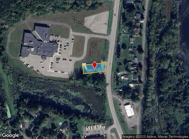
Property Record
703 State Route 28, Herkimer, NY 13350
NEARBY LISTINGS FOR SALE OR LEASE
Property Detail
703 State Route 28
213001-113-065-0002-007-000-0000
N 6 N2 6 1 6 BLDG & LOT COM
Storesoffices
Herkimer
X
New York
3603070002C
7.000
2025
0.43 AC
2024
Herkimer County
011200
Utica/Rome
3,827 SF
Utica-Rome, NY
DEMOGRAPHICS near 703 State Route 28
1 Mile
3 Mile
5 Mile
2024 Total Population
4,911
14,443
26,413
2029 Population
4,919
14,333
26,137
Pop Growth 2024-2029
+ 0.16%
(0.76%)
(1.04%)
Average Age
41
42
42
2024 Total Households
2,061
6,214
11,180
HH Growth 2024-2029
+ 0.49%
(0.71%)
(1.06%)
Median Household Inc
$51,372
$53,707
$60,448
Avg Household Size
2.10
2.10
2.20
2024 Avg HH Vehicles
1.00
1.00
2.00
Median Home Value
$101,763
$97,859
$104,947
Median Year Built
1948
1948
1948
Nearby Places
- Restaurants
- Banks
- Shops
- Fitness
- Groceries
SALE & LEASE HISTORY
LISTING DATE
SALE/LEASE

Dec 17, 2021
For Sale
Nearby Properties
Address
Land Use
TOTAL SIZE
Lot Size
Zoning
Address
Land Use
TOTAL SIZE
Lot Size
Zoning
93,840 SF
2.20 AC
C3
Address
Land Use
TOTAL SIZE
Lot Size
Zoning
151,309 SF
11.50 AC
R3
Address
Land Use
TOTAL SIZE
Lot Size
Zoning
90,636 SF
2.10 AC
C
Address
Land Use
TOTAL SIZE
Lot Size
Zoning
1 AC
GB
Address
Land Use
TOTAL SIZE
Lot Size
Zoning
208,087 SF
18.72 AC
C2
Address
Land Use
TOTAL SIZE
Lot Size
Zoning
122,210 SF
12.50 AC
I1
Address
Land Use
TOTAL SIZE
Lot Size
Zoning
221.80 AC
A
Address
Land Use
TOTAL SIZE
Lot Size
Zoning
206,440 SF
6.60 AC
R
Address
Land Use
TOTAL SIZE
Lot Size
Zoning
139,863 SF
16.90 AC
Address
Land Use
TOTAL SIZE
Lot Size
Zoning
19,680 SF
1.10 AC
R3
Address
Land Use
TOTAL SIZE
Lot Size
Zoning
267,566 SF
22.40 AC
M1
Address
Land Use
TOTAL SIZE
Lot Size
Zoning
81,816 SF
1.50 AC
R3
Address
Land Use
TOTAL SIZE
Lot Size
Zoning
77,493 SF
9.70 AC
R3
Address
Land Use
TOTAL SIZE
Lot Size
Zoning
77,280 SF
1.80 AC
PS
Address
Land Use
TOTAL SIZE
Lot Size
Zoning
82,165 SF
4.70 AC
R
Address
Land Use
TOTAL SIZE
Lot Size
Zoning
56,530 SF
10.50 AC
C1
Address
Land Use
TOTAL SIZE
Lot Size
Zoning
98,801 SF
59 AC
R2
Address
Land Use
TOTAL SIZE
Lot Size
Zoning
26,799 SF
1.50 AC
R3
Address
Land Use
TOTAL SIZE
Lot Size
Zoning
24,960 SF
3.10 AC
PS
Address
Land Use
TOTAL SIZE
Lot Size
Zoning
1,503 SF
3.49 AC
C
Address
Land Use
TOTAL SIZE
Lot Size
Zoning
2,662 SF
3.90 AC
C
Address
Land Use
TOTAL SIZE
Lot Size
Zoning
48,893 SF
1.50 AC
C
Address
Land Use
TOTAL SIZE
Lot Size
Zoning
80,832 SF
1.91 AC
B1
Address
Land Use
TOTAL SIZE
Lot Size
Zoning
14,841 SF
1.67 AC
C2
Address
Land Use
TOTAL SIZE
Lot Size
Zoning
19,500 SF
0.80 AC
R2
Address
Land Use
TOTAL SIZE
Lot Size
Zoning
18,050 SF
0.56 AC
C3
Address
Land Use
TOTAL SIZE
Lot Size
Zoning
19,142 SF
2.50 AC
C2
Address
Land Use
TOTAL SIZE
Lot Size
Zoning
22,152 SF
3.10 AC
B2
Address
Land Use
TOTAL SIZE
Lot Size
Zoning
159,334 SF
8.20 AC
Address
Land Use
TOTAL SIZE
Lot Size
Zoning
12,808 SF
5.10 AC
The World's #1 Commercial Real Estate Marketplace
Connect with us
© 2025 CoStar Group
The information above has been obtained from sources believed reliable. While we do not doubt its accuracy we have not verified it and make no guarantee, warranty or representation about it. It is your responsibility to independently confirm its accuracy and completeness. Any projections, opinions, assumptions, or estimates used are for example only and do not represent the current or future performance of the property. The value of this transaction to you depends on tax and other factors which should be evaluated by your tax, financial, and legal advisors. You and your advisors should conduct a careful, independent investigation of the property to determine to your satisfaction the suitability of the property for your needs.