Property Record
703 Bumpas St, Mckinney, TX 75069
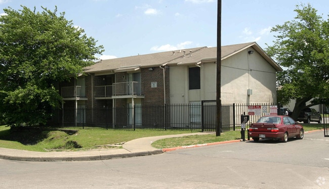

Property Detail
703 Bumpas St
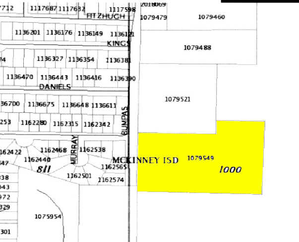
R-7000-000-0140-1
ABS A1000 G WILSON SURVEY, TRACT 14, 5.997 ACRES
Multifamilydwelling
Collin
MF-M
Texas
B and X Area of moderate flood hazard, usually the area between the limits of the 100-year and 500-year floods.
14
2025
6 AC
2025
Allen/McKinney
030903
Dallas/Ft Worth
84,200 SF
Dallas-Fort Worth-Arlington, TX
NEARBY LISTINGS FOR SALE OR LEASE
-
-
View all Mckinney listings for sale on LoopNet.com
DEMOGRAPHICS near 703 Bumpas St
1 mile
3 mile
5 mile
2025 Total Population
8,751
45,625
138,096
2030 Population
9,984
52,287
158,650
Pop Growth 2025-2030
+ 14.09%
+ 14.60%
+ 14.88%
Average Age
36
38
39
2025 Total Households
2,840
17,382
48,353
HH Growth 2025-2030
+ 14.30%
+ 14.83%
+ 15.13%
Median Household Inc
$58,594
$79,550
$104,940
Avg Household Size
2.90
2.50
2.80
2025 Avg HH Vehicles
2.00
2.00
2.00
Median Home Value
$357,191
$432,322
$473,098
Median Year Built
1991
1997
2004
Nearby Places
Map Layers
Map Styles
 Street
 Aerial
Transit
 Traffic
 Biking
Places
Listings with unknown addresses are not visible on the map
- Restaurants
- Banks
- Shops
- Fitness
- Groceries
PUBLIC TRANSPORTATION
AIRPORT
Dallas Love Field
Drive
Walk
Distance
Dallas Love Field
45 min
34.1 mi
Freight Ports
Port of Shreveport
Drive
Walk
Distance
Port of Shreveport
241 min
220.3 mi
Nearby Properties
Address
Land Use
TOTAL SIZE
Lot Size
Zoning
Address
Land Use
TOTAL SIZE
Lot Size
Zoning
638,539 SF
42.76 AC
Address
Land Use
TOTAL SIZE
Lot Size
Zoning
475,847 SF
16.34 AC
RG-18
Address
Land Use
TOTAL SIZE
Lot Size
Zoning
879,029 SF
50.26 AC
ML
Address
Land Use
TOTAL SIZE
Lot Size
Zoning
727,459 SF
48.83 AC
Address
Land Use
TOTAL SIZE
Lot Size
Zoning
725,223 SF
46.60 AC
Address
Land Use
TOTAL SIZE
Lot Size
Zoning
337,121 SF
9.39 AC
Address
Land Use
TOTAL SIZE
Lot Size
Zoning
321,982 SF
22.83 AC
SFR
Address
Land Use
TOTAL SIZE
Lot Size
Zoning
272,853 SF
17.32 AC
PD/ML
Address
Land Use
TOTAL SIZE
Lot Size
Zoning
1,708,448 SF
85.24 AC
Address
Land Use
TOTAL SIZE
Lot Size
Zoning
281,420 SF
9.43 AC
PD/ML
Address
Land Use
TOTAL SIZE
Lot Size
Zoning
196,145 SF
18.05 AC
Address
Land Use
TOTAL SIZE
Lot Size
Zoning
201,484 SF
48.39 AC
PD/ML
Address
Land Use
TOTAL SIZE
Lot Size
Zoning
319,712 SF
69.85 AC
Address
Land Use
TOTAL SIZE
Lot Size
Zoning
193,037 SF
12.35 AC
MF-M
Address
Land Use
TOTAL SIZE
Lot Size
Zoning
244,074 SF
13.97 AC
Address
Land Use
TOTAL SIZE
Lot Size
Zoning
131,417 SF
12 AC
AG
Address
Land Use
TOTAL SIZE
Lot Size
Zoning
304,565 SF
19.09 AC
COMM
Address
Land Use
TOTAL SIZE
Lot Size
Zoning
174,624 SF
10.05 AC
Address
Land Use
TOTAL SIZE
Lot Size
Zoning
207,328 SF
15.10 AC
SFR
Address
Land Use
TOTAL SIZE
Lot Size
Zoning
96,408 SF
16.65 AC
Address
Land Use
TOTAL SIZE
Lot Size
Zoning
167,735 SF
5.08 AC
PD
Address
Land Use
TOTAL SIZE
Lot Size
Zoning
119,230 SF
5.44 AC
Address
Land Use
TOTAL SIZE
Lot Size
Zoning
201,899 SF
9.77 AC
MF-M
Address
Land Use
TOTAL SIZE
Lot Size
Zoning
186,291 SF
11.13 AC
Address
Land Use
TOTAL SIZE
Lot Size
Zoning
195,589 SF
12.54 AC
RG-18
Address
Land Use
TOTAL SIZE
Lot Size
Zoning
144,545 SF
13.21 AC
COMM MULTI
Address
Land Use
TOTAL SIZE
Lot Size
Zoning
231,192 SF
14.68 AC
Address
Land Use
TOTAL SIZE
Lot Size
Zoning
169,215 SF
10 AC
BN
Address
Land Use
TOTAL SIZE
Lot Size
Zoning
209,016 SF
13.60 AC
LT INDUSTR
Address
Land Use
TOTAL SIZE
Lot Size
Zoning
91,962 SF
8.29 AC
C
The World's #1 Commercial Real Estate Marketplace
Connect with us
© 2026 CoStar Group
The information above has been obtained from sources believed reliable. While we do not doubt its accuracy we have not verified it and make no guarantee, warranty or representation about it. It is your responsibility to independently confirm its accuracy and completeness. Any projections, opinions, assumptions, or estimates used are for example only and do not represent the current or future performance of the property. The value of this transaction to you depends on tax and other factors which should be evaluated by your tax, financial, and legal advisors. You and your advisors should conduct a careful, independent investigation of the property to determine to your satisfaction the suitability of the property for your needs.