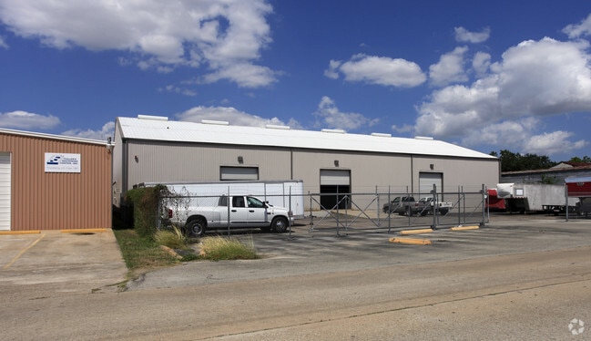
Property Record
703 Dumont St, South Houston, TX 77587

NEARBY LISTINGS FOR SALE OR LEASE
Property Detail
703 Dumont St
Houston-The Woodlands-Sugar Land, TX
South Houston
0341670320003
LTS 3 4 & 5 BLK 332 SOUTH HOUSTON
Warehouse
Harris
X
Texas
48201C0915N
3
2024
0.49 AC
2025
East-Southeast Far
321401
Houston
10,150 SF
DEMOGRAPHICS near 703 Dumont St
1 Mile
3 Mile
5 Mile
2024 Total Population
12,411
144,483
329,306
2029 Population
12,698
148,105
336,918
Pop Growth 2024-2029
+ 2.31%
+ 2.51%
+ 2.31%
Average Age
36
34
35
2024 Total Households
3,921
45,995
106,506
HH Growth 2024-2029
+ 2.40%
+ 2.58%
+ 2.33%
Median Household Inc
$56,830
$45,644
$49,853
Avg Household Size
3.10
3.00
3.00
2024 Avg HH Vehicles
2.00
2.00
2.00
Median Home Value
$151,476
$147,406
$152,718
Median Year Built
1968
1969
1971
Nearby Places
Map Layers
Map Styles
 Street
 Aerial
- Restaurants
- Banks
- Shops
- Fitness
- Groceries
PUBLIC TRANSPORTATION
AIRPORT
William P Hobby
DRIVE
WALK
Distance
William P Hobby
15 min
5.4 mi
George Bush Intcntl/Houston
DRIVE
WALK
Distance
George Bush Intcntl/Houston
40 min
31.5 mi
Freight Ports
Port of Houston
DRIVE
WALK
Distance
Port of Houston
16 min
8.4 mi
Nearby Properties
Address
Land Use
TOTAL SIZE
Lot Size
Zoning
Address
Land Use
TOTAL SIZE
Lot Size
Zoning
65.22 AC
Address
Land Use
TOTAL SIZE
Lot Size
Zoning
256.70 AC
Address
Land Use
TOTAL SIZE
Lot Size
Zoning
4.26 AC
Address
Land Use
TOTAL SIZE
Lot Size
Zoning
115.83 AC
Address
Land Use
TOTAL SIZE
Lot Size
Zoning
690,590 SF
31.88 AC
Address
Land Use
TOTAL SIZE
Lot Size
Zoning
794,499 SF
31.71 AC
Address
Land Use
TOTAL SIZE
Lot Size
Zoning
218,787 SF
10 AC
Address
Land Use
TOTAL SIZE
Lot Size
Zoning
229,446 SF
21.05 AC
Address
Land Use
TOTAL SIZE
Lot Size
Zoning
411,252 SF
18.28 AC
Address
Land Use
TOTAL SIZE
Lot Size
Zoning
281,470 SF
11.24 AC
Address
Land Use
TOTAL SIZE
Lot Size
Zoning
397,739 SF
15.93 AC
Address
Land Use
TOTAL SIZE
Lot Size
Zoning
504,938 SF
28.96 AC
Address
Land Use
TOTAL SIZE
Lot Size
Zoning
363,740 SF
16.92 AC
Address
Land Use
TOTAL SIZE
Lot Size
Zoning
342,149 SF
23.56 AC
Address
Land Use
TOTAL SIZE
Lot Size
Zoning
538,431 SF
21.31 AC
Address
Land Use
TOTAL SIZE
Lot Size
Zoning
261.10 AC
Address
Land Use
TOTAL SIZE
Lot Size
Zoning
230,218 SF
10.67 AC
Address
Land Use
TOTAL SIZE
Lot Size
Zoning
260,972 SF
23.45 AC
Address
Land Use
TOTAL SIZE
Lot Size
Zoning
321,268 SF
9.59 AC
Address
Land Use
TOTAL SIZE
Lot Size
Zoning
186,046 SF
13.34 AC
Address
Land Use
TOTAL SIZE
Lot Size
Zoning
188,110 SF
2.22 AC
Address
Land Use
TOTAL SIZE
Lot Size
Zoning
Address
Land Use
TOTAL SIZE
Lot Size
Zoning
136,335 SF
4.32 AC
Address
Land Use
TOTAL SIZE
Lot Size
Zoning
391,576 SF
19.94 AC
Address
Land Use
TOTAL SIZE
Lot Size
Zoning
446,728 SF
16.69 AC
Address
Land Use
TOTAL SIZE
Lot Size
Zoning
308,748 SF
11.34 AC
Address
Land Use
TOTAL SIZE
Lot Size
Zoning
113,688 SF
4 AC
Address
Land Use
TOTAL SIZE
Lot Size
Zoning
257,481 SF
9.28 AC
Address
Land Use
TOTAL SIZE
Lot Size
Zoning
228,900 SF
3.85 AC
Address
Land Use
TOTAL SIZE
Lot Size
Zoning
152,276 SF
6.83 AC
The World's #1 Commercial Real Estate Marketplace
Connect with us
© 2025 CoStar Group
The information above has been obtained from sources believed reliable. While we do not doubt its accuracy we have not verified it and make no guarantee, warranty or representation about it. It is your responsibility to independently confirm its accuracy and completeness. Any projections, opinions, assumptions, or estimates used are for example only and do not represent the current or future performance of the property. The value of this transaction to you depends on tax and other factors which should be evaluated by your tax, financial, and legal advisors. You and your advisors should conduct a careful, independent investigation of the property to determine to your satisfaction the suitability of the property for your needs.