Property Record
703 Mcclaine St, Silverton, OR 97381
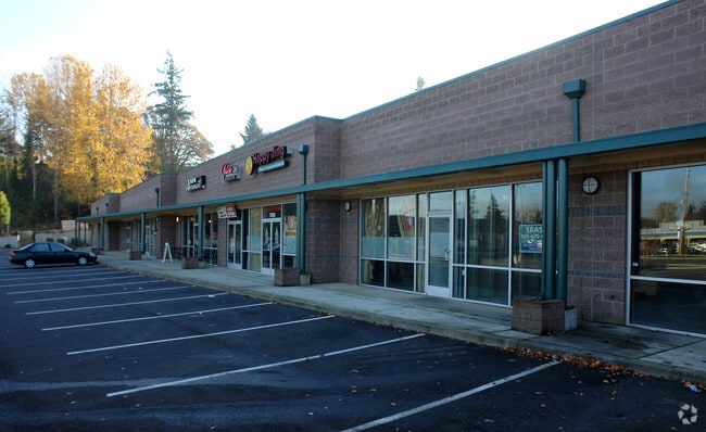

Property Detail
703 Mcclaine St
103031
PP 2015-013 LOT 2 ACRES 2.31
Officebuilding
MARION
GC
Oregon
B and X Area of moderate flood hazard, usually the area between the limits of the 100-year and 500-year floods.
2
2024
2.31 AC
2025
Marion County
010503
Portland
19,800 SF
Salem, OR
NEARBY LISTINGS FOR SALE OR LEASE
DEMOGRAPHICS near 703 Mcclaine St
1 mile
3 mile
5 mile
2025 Total Population
6,826
13,710
19,545
2030 Population
6,945
13,900
19,751
Pop Growth 2025-2030
+ 1.74%
+ 1.39%
+ 1.05%
Average Age
40
41
41
2025 Total Households
2,548
5,067
6,996
HH Growth 2025-2030
+ 1.88%
+ 1.50%
+ 1.16%
Median Household Inc
$77,578
$81,277
$81,711
Avg Household Size
2.60
2.70
2.70
2025 Avg HH Vehicles
2.00
2.00
2.00
Median Home Value
$505,534
$578,783
$574,341
Median Year Built
1977
1979
1978
Nearby Places
Map Layers
Map Styles
 Street
 Aerial
Layers
 Traffic
 Biking
Places
Listings with unknown addresses are not visible on the map
- Restaurants
- Banks
- Shops
- Fitness
- Groceries
SALE & LEASE HISTORY
LISTING DATE
SALE/LEASE

Sep 25, 2016
For Lease
Jul 13, 2017
For Lease
Nearby Properties
Address
Land Use
TOTAL SIZE
Lot Size
Zoning
Address
Land Use
TOTAL SIZE
Lot Size
Zoning
91,721 SF
4.66 AC
P
Address
Land Use
TOTAL SIZE
Lot Size
Zoning
39,543 SF
126.95 AC
P
Address
Land Use
TOTAL SIZE
Lot Size
Zoning
67,729 SF
11.01 AC
P
Address
Land Use
TOTAL SIZE
Lot Size
Zoning
90,019 SF
4.67 AC
RM-10
Address
Land Use
TOTAL SIZE
Lot Size
Zoning
176,475 SF
19.12 AC
IP
Address
Land Use
TOTAL SIZE
Lot Size
Zoning
20,618 SF
18.17 AC
P
Address
Land Use
TOTAL SIZE
Lot Size
Zoning
Address
Land Use
TOTAL SIZE
Lot Size
Zoning
63,408 SF
3.47 AC
RM-20
Address
Land Use
TOTAL SIZE
Lot Size
Zoning
42,184 SF
3.21 AC
GC
Address
Land Use
TOTAL SIZE
Lot Size
Zoning
84,423 SF
4.39 AC
LI
Address
Land Use
TOTAL SIZE
Lot Size
Zoning
5.41 AC
IP
Address
Land Use
TOTAL SIZE
Lot Size
Zoning
35,357 SF
3.81 AC
GC
Address
Land Use
TOTAL SIZE
Lot Size
Zoning
9,297 SF
17.24 AC
C
Address
Land Use
TOTAL SIZE
Lot Size
Zoning
20,676 SF
2.37 AC
R-5
Address
Land Use
TOTAL SIZE
Lot Size
Zoning
49,188 SF
4.12 AC
GC
Address
Land Use
TOTAL SIZE
Lot Size
Zoning
17,128 SF
1.31 AC
GC
Address
Land Use
TOTAL SIZE
Lot Size
Zoning
21,722 SF
0.96 AC
RM-10
Address
Land Use
TOTAL SIZE
Lot Size
Zoning
38,311 SF
5.50 AC
R-5
Address
Land Use
TOTAL SIZE
Lot Size
Zoning
Address
Land Use
TOTAL SIZE
Lot Size
Zoning
42,400 SF
6.90 AC
IP
Address
Land Use
TOTAL SIZE
Lot Size
Zoning
68,144 SF
4.05 AC
IP
Address
Land Use
TOTAL SIZE
Lot Size
Zoning
21,182 SF
2.92 AC
R-1
Address
Land Use
TOTAL SIZE
Lot Size
Zoning
Address
Land Use
TOTAL SIZE
Lot Size
Zoning
20,034 SF
2.40 AC
GC
Address
Land Use
TOTAL SIZE
Lot Size
Zoning
Address
Land Use
TOTAL SIZE
Lot Size
Zoning
24,933 SF
3.06 AC
IP
Address
Land Use
TOTAL SIZE
Lot Size
Zoning
9.78 AC
I
Address
Land Use
TOTAL SIZE
Lot Size
Zoning
20,596 SF
1.26 AC
IP
Address
Land Use
TOTAL SIZE
Lot Size
Zoning
8,886 SF
0.93 AC
GC
The World's #1 Commercial Real Estate Marketplace
Connect with us
© 2026 CoStar Group
The information above has been obtained from sources believed reliable. While we do not doubt its accuracy we have not verified it and make no guarantee, warranty or representation about it. It is your responsibility to independently confirm its accuracy and completeness. Any projections, opinions, assumptions, or estimates used are for example only and do not represent the current or future performance of the property. The value of this transaction to you depends on tax and other factors which should be evaluated by your tax, financial, and legal advisors. You and your advisors should conduct a careful, independent investigation of the property to determine to your satisfaction the suitability of the property for your needs.