Property Record
703 N Clark St, Albion, MI 49224
NEARBY LISTINGS FOR SALE OR LEASE
-
-
View all Albion listings for sale on LoopNet.com
Property Detail
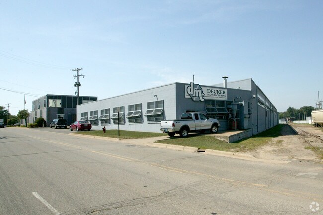
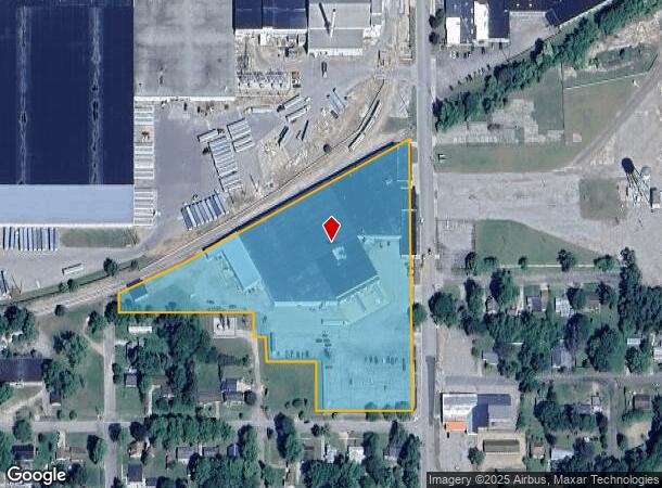
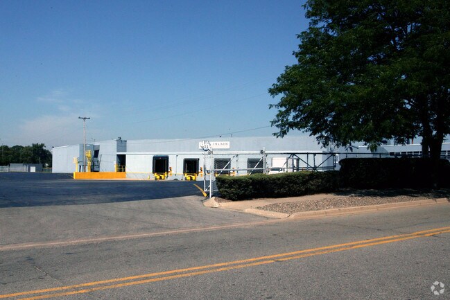
703 N Clark St
Battle Creek, MI
G F Bundays Add
51-003-419-01
ALBION CITY, GF BUNDAY'S ADDITION BLK 8, LOTS 8, 11, 12, 13, & 14 AND BLOCK 9, LOTS 3 - 21 AND 1/2 VACATED LOMBARD ST
Manufacturinglight
Calhoun
X
Michigan
26025C0290C
3-21
2024
6.77 AC
2025
Eastern Calhoun County
003500
West Michigan
128,884 SF
DEMOGRAPHICS near 703 N Clark St
1 Mile
3 Mile
5 Mile
2024 Total Population
4,913
10,221
12,482
2029 Population
4,968
10,310
12,538
Pop Growth 2024-2029
+ 1.12%
+ 0.87%
+ 0.45%
Average Age
37
38
38
2024 Total Households
1,716
3,786
4,663
HH Growth 2024-2029
+ 1.46%
+ 1.11%
+ 0.62%
Median Household Inc
$42,060
$39,672
$43,276
Avg Household Size
2.30
2.40
2.40
2024 Avg HH Vehicles
2.00
2.00
2.00
Median Home Value
$77,817
$88,175
$102,479
Median Year Built
1948
1950
1952
Nearby Places
Map Layers
Map Styles
 Street
 Aerial
- Restaurants
- Banks
- Shops
- Fitness
- Groceries
PUBLIC TRANSPORTATION
COMMUTER RAIL
DRIVE
WALK
Distance
3 min
1.3 mi
Nearby Properties
Address
Land Use
TOTAL SIZE
Lot Size
Zoning
Address
Land Use
TOTAL SIZE
Lot Size
Zoning
844,532 SF
36.92 AC
M-1
Address
Land Use
TOTAL SIZE
Lot Size
Zoning
184,000 SF
M1
Address
Land Use
TOTAL SIZE
Lot Size
Zoning
92,597 SF
38.57 AC
LI/LIGHT I
Address
Land Use
TOTAL SIZE
Lot Size
Zoning
35,709 SF
HI/HEAVY I
Address
Land Use
TOTAL SIZE
Lot Size
Zoning
59,140 SF
1.58 AC
CBD
Address
Land Use
TOTAL SIZE
Lot Size
Zoning
126,528 SF
19.97 AC
M-2
Address
Land Use
TOTAL SIZE
Lot Size
Zoning
69,370 SF
7.89 AC
M-1
Address
Land Use
TOTAL SIZE
Lot Size
Zoning
76,157 SF
9.12 AC
C
Address
Land Use
TOTAL SIZE
Lot Size
Zoning
42,500 SF
86.43 AC
R-2
Address
Land Use
TOTAL SIZE
Lot Size
Zoning
111,520 SF
12.33 AC
M-1
Address
Land Use
TOTAL SIZE
Lot Size
Zoning
Address
Land Use
TOTAL SIZE
Lot Size
Zoning
37.31 AC
R-2
Address
Land Use
TOTAL SIZE
Lot Size
Zoning
1,127 SF
42.62 AC
AA/AGRICUL
Address
Land Use
TOTAL SIZE
Lot Size
Zoning
24,791 SF
1.13 AC
MU
Address
Land Use
TOTAL SIZE
Lot Size
Zoning
8,816 SF
Address
Land Use
TOTAL SIZE
Lot Size
Zoning
39,417 SF
3.21 AC
C
Address
Land Use
TOTAL SIZE
Lot Size
Zoning
14,146 SF
1.60 AC
CD
Address
Land Use
TOTAL SIZE
Lot Size
Zoning
12,736 SF
3.10 AC
AA/AGRICUL
Address
Land Use
TOTAL SIZE
Lot Size
Zoning
38,894 SF
6.44 AC
HS/HWY.SVC
Address
Land Use
TOTAL SIZE
Lot Size
Zoning
10,764 SF
B2
Address
Land Use
TOTAL SIZE
Lot Size
Zoning
1,400 SF
2.85 AC
I-1
Address
Land Use
TOTAL SIZE
Lot Size
Zoning
29,239 SF
1.36 AC
MU
Address
Land Use
TOTAL SIZE
Lot Size
Zoning
71,117 SF
11.58 AC
C
Address
Land Use
TOTAL SIZE
Lot Size
Zoning
3,564 SF
29.42 AC
R-2
Address
Land Use
TOTAL SIZE
Lot Size
Zoning
26,672 SF
5.12 AC
M-1
Address
Land Use
TOTAL SIZE
Lot Size
Zoning
2,048 SF
230.85 AC
AG
Address
Land Use
TOTAL SIZE
Lot Size
Zoning
284,079 SF
23.29 AC
AA/AGRICUL
Address
Land Use
TOTAL SIZE
Lot Size
Zoning
2,657 SF
176.79 AC
AG 1
Address
Land Use
TOTAL SIZE
Lot Size
Zoning
222.19 AC
AA/AGRICUL
The World's #1 Commercial Real Estate Marketplace
Connect with us
© 2026 CoStar Group
The information above has been obtained from sources believed reliable. While we do not doubt its accuracy we have not verified it and make no guarantee, warranty or representation about it. It is your responsibility to independently confirm its accuracy and completeness. Any projections, opinions, assumptions, or estimates used are for example only and do not represent the current or future performance of the property. The value of this transaction to you depends on tax and other factors which should be evaluated by your tax, financial, and legal advisors. You and your advisors should conduct a careful, independent investigation of the property to determine to your satisfaction the suitability of the property for your needs.