Property Record
702 N Highway 78, Wylie, TX 75098


This Property Is For Sale
Property Detail
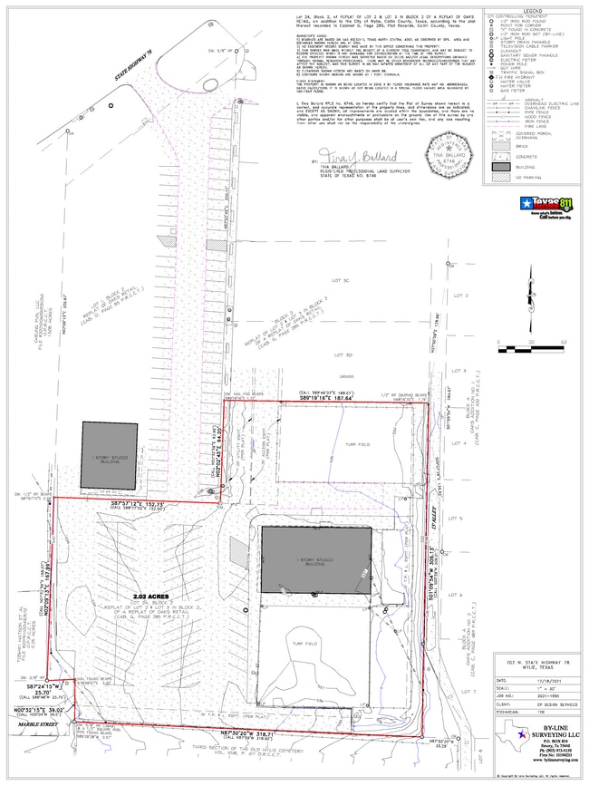
702 N Highway 78
R-1467-002-002A-1
OAKS RETAIL, BLK 2, LOT 2A
Commercialnec
Collin
CC
Texas
B and X Area of moderate flood hazard, usually the area between the limits of the 100-year and 500-year floods.
2a
2025
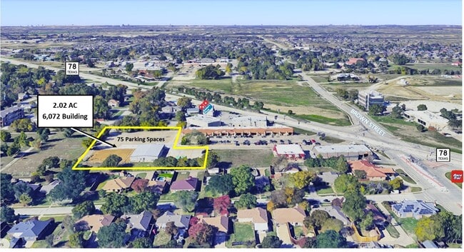
2.04 AC
2025
Murphy/Wylie
031319
Dallas/Ft Worth
6,000 SF
Dallas-Fort Worth-Arlington, TX
NEARBY LISTINGS FOR SALE OR LEASE
DEMOGRAPHICS near 702 N Highway 78
1 mile
3 mile
5 mile
2025 Total Population
10,771
61,902
133,186
2030 Population
12,246
70,451
150,433
Pop Growth 2025-2030
+ 13.69%
+ 13.81%
+ 12.95%
Average Age
38
37
37
2025 Total Households
3,642
19,712
41,955
HH Growth 2025-2030
+ 13.87%
+ 13.99%
+ 13.14%
Median Household Inc
$98,229
$119,983
$128,894
Avg Household Size
2.90
3.10
3.20
2025 Avg HH Vehicles
2.00
2.00
2.00
Median Home Value
$368,050
$430,677
$457,351
Median Year Built
2001
2005
2006
Nearby Places
Map Layers
Map Styles
 Street
 Aerial
Transit
 Traffic
 Biking
Places
Listings with unknown addresses are not visible on the map
- Restaurants
- Banks
- Shops
- Fitness
- Groceries
PUBLIC TRANSPORTATION
AIRPORT
Dallas Love Field
Drive
Walk
Distance
Dallas Love Field
45 min
29.9 mi
Freight Ports
Port of Shreveport
Drive
Walk
Distance
Port of Shreveport
224 min
196.5 mi
Nearby Properties
Address
Land Use
TOTAL SIZE
Lot Size
Zoning
Address
Land Use
TOTAL SIZE
Lot Size
Zoning
603,573 SF
58.20 AC
Address
Land Use
TOTAL SIZE
Lot Size
Zoning
339,663 SF
95.04 AC
Address
Land Use
TOTAL SIZE
Lot Size
Zoning
285,392 SF
19.44 AC
MF-M
Address
Land Use
TOTAL SIZE
Lot Size
Zoning
441,356 SF
74.94 AC
Address
Land Use
TOTAL SIZE
Lot Size
Zoning
266,957 SF
11.34 AC
MFR
Address
Land Use
TOTAL SIZE
Lot Size
Zoning
393,054 SF
55.95 AC
Address
Land Use
TOTAL SIZE
Lot Size
Zoning
257,718 SF
13.10 AC
RESIDENTIA
Address
Land Use
TOTAL SIZE
Lot Size
Zoning
228,536 SF
10.54 AC
MF-M
Address
Land Use
TOTAL SIZE
Lot Size
Zoning
203,383 SF
11.91 AC
MF-M
Address
Land Use
TOTAL SIZE
Lot Size
Zoning
274,329 SF
44.89 AC
Address
Land Use
TOTAL SIZE
Lot Size
Zoning
274,416 SF
18.40 AC
PD
Address
Land Use
TOTAL SIZE
Lot Size
Zoning
140,130 SF
19.67 AC
Address
Land Use
TOTAL SIZE
Lot Size
Zoning
85,393 SF
10 AC
Address
Land Use
TOTAL SIZE
Lot Size
Zoning
132,306 SF
7.85 AC
MF
Address
Land Use
TOTAL SIZE
Lot Size
Zoning
77,225 SF
9.59 AC
Address
Land Use
TOTAL SIZE
Lot Size
Zoning
106,866 SF
15.69 AC
Address
Land Use
TOTAL SIZE
Lot Size
Zoning
97,898 SF
10.82 AC
Address
Land Use
TOTAL SIZE
Lot Size
Zoning
203,192 SF
17.69 AC
Address
Land Use
TOTAL SIZE
Lot Size
Zoning
123,621 SF
12.22 AC
Address
Land Use
TOTAL SIZE
Lot Size
Zoning
128,849 SF
7.70 AC
Address
Land Use
TOTAL SIZE
Lot Size
Zoning
141,396 SF
8.40 AC
NS
Address
Land Use
TOTAL SIZE
Lot Size
Zoning
304,978 SF
81.51 AC
Address
Land Use
TOTAL SIZE
Lot Size
Zoning
145,268 SF
16.34 AC
Address
Land Use
TOTAL SIZE
Lot Size
Zoning
221,982 SF
17.21 AC
Address
Land Use
TOTAL SIZE
Lot Size
Zoning
51,878 SF
3.30 AC
PD
Address
Land Use
TOTAL SIZE
Lot Size
Zoning
121,926 SF
2.08 AC
Address
Land Use
TOTAL SIZE
Lot Size
Zoning
105,113 SF
2.12 AC
PD
Address
Land Use
TOTAL SIZE
Lot Size
Zoning
145,635 SF
12.15 AC
Address
Land Use
TOTAL SIZE
Lot Size
Zoning
125,000 SF
22.42 AC
FLOOD
Address
Land Use
TOTAL SIZE
Lot Size
Zoning
91,585 SF
4.33 AC
I
The World's #1 Commercial Real Estate Marketplace
Connect with us
© 2026 CoStar Group
The information above has been obtained from sources believed reliable. While we do not doubt its accuracy we have not verified it and make no guarantee, warranty or representation about it. It is your responsibility to independently confirm its accuracy and completeness. Any projections, opinions, assumptions, or estimates used are for example only and do not represent the current or future performance of the property. The value of this transaction to you depends on tax and other factors which should be evaluated by your tax, financial, and legal advisors. You and your advisors should conduct a careful, independent investigation of the property to determine to your satisfaction the suitability of the property for your needs.