Property Record
703 Powers Ferry Rd Se, Marietta, GA 30067
NEARBY LISTINGS FOR SALE OR LEASE
-
-
View all Marietta listings for sale on LoopNet.com
Property Detail
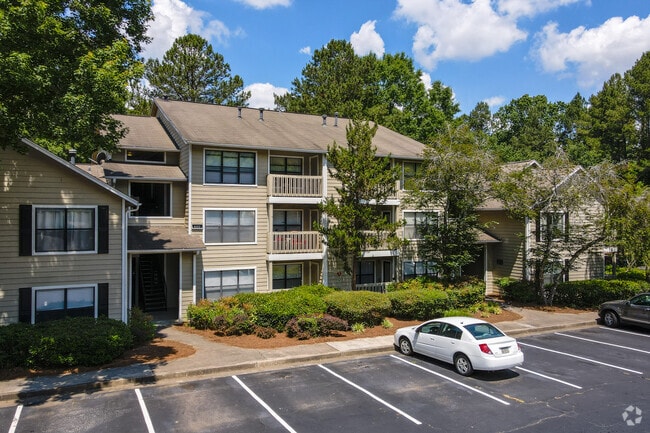
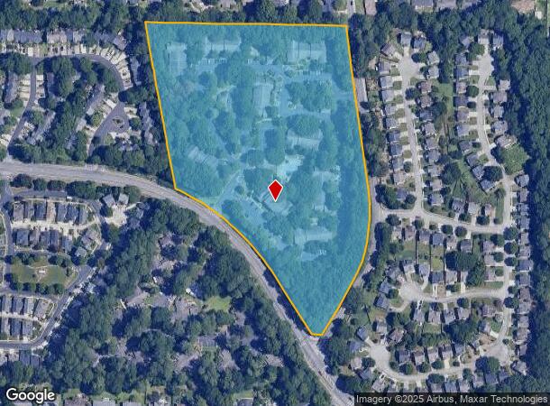
703 Powers Ferry Rd Se
17-0795-0-002-0
Alta/Acsm Land Title Surv
Apartment
Cobb
X
Georgia
13067C0136G
13.50 AC
2025
East Cobb
2025
Atlanta
030405
Atlanta-Sandy Springs-Roswell, GA
132,868 SF
DEMOGRAPHICS near 703 Powers Ferry Rd Se
1 Mile
3 Mile
5 Mile
2024 Total Population
13,285
82,168
222,807
2029 Population
13,629
83,794
227,111
Pop Growth 2024-2029
+ 2.59%
+ 1.98%
+ 1.93%
Average Age
37
37
38
2024 Total Households
5,951
35,312
93,832
HH Growth 2024-2029
+ 2.60%
+ 1.90%
+ 1.89%
Median Household Inc
$68,521
$71,023
$81,744
Avg Household Size
2.20
2.20
2.30
2024 Avg HH Vehicles
2.00
2.00
2.00
Median Home Value
$323,631
$375,040
$399,632
Median Year Built
1979
1983
1984
Nearby Places
Map Layers
Map Styles
 Street
 Aerial
- Restaurants
- Banks
- Shops
- Fitness
- Groceries
PUBLIC TRANSPORTATION
AIRPORT
Hartsfield - Jackson Atlanta International
DRIVE
WALK
Distance
Hartsfield - Jackson Atlanta International
37 min
25.6 mi
Freight Ports
Georgia Ports - Savannah
DRIVE
WALK
Distance
Georgia Ports - Savannah
299 min
264.9 mi
Nearby Properties
Address
Land Use
TOTAL SIZE
Lot Size
Zoning
Address
Land Use
TOTAL SIZE
Lot Size
Zoning
1,221,836 SF
12.32 AC
GC
Address
Land Use
TOTAL SIZE
Lot Size
Zoning
553,125 SF
42.07 AC
PRD MF
Address
Land Use
TOTAL SIZE
Lot Size
Zoning
237,743 SF
10.32 AC
RRC
Address
Land Use
TOTAL SIZE
Lot Size
Zoning
1,779,364 SF
8.66 AC
OHR
Address
Land Use
TOTAL SIZE
Lot Size
Zoning
583,570 SF
4.56 AC
PVC/OI
Address
Land Use
TOTAL SIZE
Lot Size
Zoning
3.51 AC
RRC
Address
Land Use
TOTAL SIZE
Lot Size
Zoning
612,660 SF
46.67 AC
RM-16
Address
Land Use
TOTAL SIZE
Lot Size
Zoning
379,000 SF
29.86 AC
RM-12
Address
Land Use
TOTAL SIZE
Lot Size
Zoning
643,086 SF
40.63 AC
RM-12
Address
Land Use
TOTAL SIZE
Lot Size
Zoning
486,095 SF
5.57 AC
UC
Address
Land Use
TOTAL SIZE
Lot Size
Zoning
437,793 SF
41.12 AC
RM-16
Address
Land Use
TOTAL SIZE
Lot Size
Zoning
5.50 AC
RRC
Address
Land Use
TOTAL SIZE
Lot Size
Zoning
473,199 SF
24.09 AC
RM-16
Address
Land Use
TOTAL SIZE
Lot Size
Zoning
364,064 SF
21.17 AC
RM-12
Address
Land Use
TOTAL SIZE
Lot Size
Zoning
416,113 SF
28.12 AC
RM-12
Address
Land Use
TOTAL SIZE
Lot Size
Zoning
404,428 SF
2.90 AC
UVC
Address
Land Use
TOTAL SIZE
Lot Size
Zoning
9,242 SF
2.93 AC
GC
Address
Land Use
TOTAL SIZE
Lot Size
Zoning
122,154 SF
3.40 AC
RRC
Address
Land Use
TOTAL SIZE
Lot Size
Zoning
85,489 SF
6.20 AC
PRD MF
Address
Land Use
TOTAL SIZE
Lot Size
Zoning
452,366 SF
27.27 AC
PRD MF
Address
Land Use
TOTAL SIZE
Lot Size
Zoning
494,076 SF
33.30 AC
PRD MF
Address
Land Use
TOTAL SIZE
Lot Size
Zoning
19,500 SF
3.70 AC
RRC
Address
Land Use
TOTAL SIZE
Lot Size
Zoning
582,685 SF
37.58 AC
PVC
Address
Land Use
TOTAL SIZE
Lot Size
Zoning
300,404 SF
22.23 AC
RM-16
Address
Land Use
TOTAL SIZE
Lot Size
Zoning
646,916 SF
8.06 AC
OI
Address
Land Use
TOTAL SIZE
Lot Size
Zoning
300,105 SF
43.12 AC
RM-8
Address
Land Use
TOTAL SIZE
Lot Size
Zoning
343,570 SF
22.65 AC
PRD MF
Address
Land Use
TOTAL SIZE
Lot Size
Zoning
344,024 SF
35.69 AC
RM-12
Address
Land Use
TOTAL SIZE
Lot Size
Zoning
8,000 SF
9.57 AC
PRD MF
Address
Land Use
TOTAL SIZE
Lot Size
Zoning
464,381 SF
34.82 AC
RM-12
The World's #1 Commercial Real Estate Marketplace
Connect with us
© 2026 CoStar Group
The information above has been obtained from sources believed reliable. While we do not doubt its accuracy we have not verified it and make no guarantee, warranty or representation about it. It is your responsibility to independently confirm its accuracy and completeness. Any projections, opinions, assumptions, or estimates used are for example only and do not represent the current or future performance of the property. The value of this transaction to you depends on tax and other factors which should be evaluated by your tax, financial, and legal advisors. You and your advisors should conduct a careful, independent investigation of the property to determine to your satisfaction the suitability of the property for your needs.