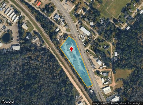
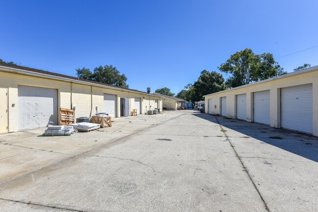
Property Record
703 S State St, Bunnell, FL 32110
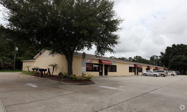
This Property Is For Sale
NEARBY LISTINGS FOR SALE OR LEASE
Property Detail
703 S State St
10-12-30-0850-02990-0000
Town Of Bunnell
Regionalshoppingcenterormallwithanchorstore
TOWN OF BUNNELL BLKS 299 & 300 LYING WEST OF US-1 & 1/2 OF VACANTED SHORT STREET LYING SOUTH OF BLK 299 ALSO 2.+/- AC BUNNELL DEV CO SUBD BLK C PT TR 5 LYING S OF BLK 300 & BETWEEN US-1 & FEC R/R PARCEL HAS 234. ON WLY BOUNDARY US-1 & 301.47 ON ELY B
X
Flagler
12035C0209E
Florida
2024
2.90 AC
2025
Daytona Area
060207
Other Market Areas
20,878 SF
Deltona-Daytona Beach-Ormond Beach, FL
DEMOGRAPHICS near 703 S State St
1 Mile
3 Mile
5 Mile
2024 Total Population
1,929
14,072
45,511
2029 Population
2,318
17,167
55,757
Pop Growth 2024-2029
+ 20.17%
+ 21.99%
+ 22.51%
Average Age
43
46
45
2024 Total Households
706
5,639
17,841
HH Growth 2024-2029
+ 19.41%
+ 21.30%
+ 21.80%
Median Household Inc
$35,739
$59,831
$61,894
Avg Household Size
2.40
2.40
2.50
2024 Avg HH Vehicles
1.00
2.00
2.00
Median Home Value
$214,216
$280,111
$256,230
Median Year Built
1985
2003
2003
Nearby Places
- Restaurants
- Banks
- Shops
- Fitness
- Groceries
PUBLIC TRANSPORTATION
AIRPORT
Daytona Beach International
DRIVE
WALK
Distance
Daytona Beach International
35 min
25.9 mi
Nearby Properties
Address
Land Use
TOTAL SIZE
Lot Size
Zoning
Address
Land Use
TOTAL SIZE
Lot Size
Zoning
913,614 SF
85.53 AC
PSP
Address
Land Use
TOTAL SIZE
Lot Size
Zoning
320,259 SF
83.19 AC
P
Address
Land Use
TOTAL SIZE
Lot Size
Zoning
217,927 SF
1,165.37 AC
I-C
Address
Land Use
TOTAL SIZE
Lot Size
Zoning
280,742 SF
16.06 AC
MPD
Address
Land Use
TOTAL SIZE
Lot Size
Zoning
236,316 SF
61.38 AC
PSP
Address
Land Use
TOTAL SIZE
Lot Size
Zoning
138,991 SF
18.66 AC
P
Address
Land Use
TOTAL SIZE
Lot Size
Zoning
121,173 SF
10 AC
AC
Address
Land Use
TOTAL SIZE
Lot Size
Zoning
64,208 SF
8.41 AC
PSP
Address
Land Use
TOTAL SIZE
Lot Size
Zoning
76,544 SF
48.85 AC
R/C
Address
Land Use
TOTAL SIZE
Lot Size
Zoning
220,314 SF
17.41 AC
MPD
Address
Land Use
TOTAL SIZE
Lot Size
Zoning
68,684 SF
9.68 AC
MPD
Address
Land Use
TOTAL SIZE
Lot Size
Zoning
89,590 SF
9.90 AC
B-1
Address
Land Use
TOTAL SIZE
Lot Size
Zoning
59,889 SF
0.75 AC
R-3A
Address
Land Use
TOTAL SIZE
Lot Size
Zoning
67,008 SF
5.34 AC
B-1
Address
Land Use
TOTAL SIZE
Lot Size
Zoning
20,990 SF
18.10 AC
Address
Land Use
TOTAL SIZE
Lot Size
Zoning
32,679 SF
101.42 AC
L-1
Address
Land Use
TOTAL SIZE
Lot Size
Zoning
41,710 SF
11.97 AC
L-1
Address
Land Use
TOTAL SIZE
Lot Size
Zoning
4,158 SF
3.73 AC
P
Address
Land Use
TOTAL SIZE
Lot Size
Zoning
74,470 SF
11.98 AC
MPD
Address
Land Use
TOTAL SIZE
Lot Size
Zoning
43,990 SF
4.84 AC
P
Address
Land Use
TOTAL SIZE
Lot Size
Zoning
18,852 SF
3.23 AC
COM-2
Address
Land Use
TOTAL SIZE
Lot Size
Zoning
38,420 SF
4.83 AC
C-2(F)
Address
Land Use
TOTAL SIZE
Lot Size
Zoning
60,582 SF
2.20 AC
MPD
Address
Land Use
TOTAL SIZE
Lot Size
Zoning
76,339 SF
4 AC
B-1
Address
Land Use
TOTAL SIZE
Lot Size
Zoning
10,310 SF
1.54 AC
Address
Land Use
TOTAL SIZE
Lot Size
Zoning
66,485 SF
28.20 AC
Address
Land Use
TOTAL SIZE
Lot Size
Zoning
17,901 SF
1.72 AC
COM-2
Address
Land Use
TOTAL SIZE
Lot Size
Zoning
41,293 SF
4.92 AC
B-1
The World's #1 Commercial Real Estate Marketplace
Connect with us
© 2025 CoStar Group
The information above has been obtained from sources believed reliable. While we do not doubt its accuracy we have not verified it and make no guarantee, warranty or representation about it. It is your responsibility to independently confirm its accuracy and completeness. Any projections, opinions, assumptions, or estimates used are for example only and do not represent the current or future performance of the property. The value of this transaction to you depends on tax and other factors which should be evaluated by your tax, financial, and legal advisors. You and your advisors should conduct a careful, independent investigation of the property to determine to your satisfaction the suitability of the property for your needs.