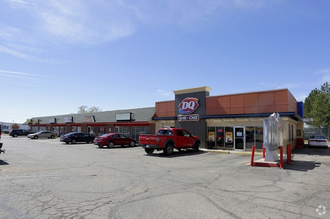
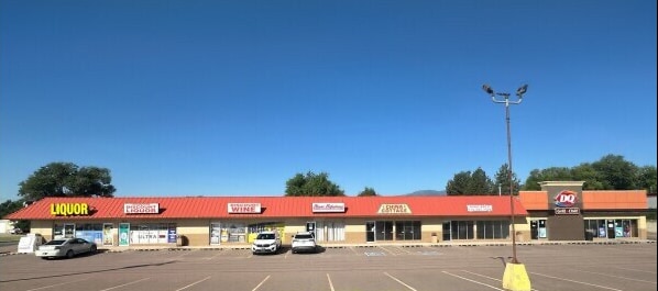
Property Record
7010 S Us Highway 85-87, Fountain, CO 80817


Current Lease Availabilities
NEARBY LISTINGS FOR SALE OR LEASE
Property Detail
7010 S Us Highway 85-87
Colorado Springs, CO
Southmoor Sub Add No 1 Replat Of Blk 5
65241-07-019
LOTS 1, 2 BLK 1 REPLAT OF BLK 5 SOUTHMOOR SUB ADD NO 1 FOUNTAIN
Commercialbuilding
El Paso
X
Colorado
08041C0951G
1,2
2024
1.01 AC
2025
Southeast
004513
Colorado Springs
12,000 SF
DEMOGRAPHICS near 7010 S Us Highway 85-87
1 Mile
3 Mile
5 Mile
2024 Total Population
8,291
48,332
120,457
2029 Population
8,567
50,029
125,578
Pop Growth 2024-2029
+ 3.33%
+ 3.51%
+ 4.25%
Average Age
38
36
33
2024 Total Households
2,937
16,362
37,100
HH Growth 2024-2029
+ 3.51%
+ 3.70%
+ 4.52%
Median Household Inc
$68,356
$75,403
$71,402
Avg Household Size
2.70
2.90
3.00
2024 Avg HH Vehicles
2.00
2.00
2.00
Median Home Value
$301,310
$323,921
$326,226
Median Year Built
1969
1986
1990
Nearby Places
Map Layers
Map Styles
 Street
 Aerial
- Restaurants
- Banks
- Shops
- Fitness
- Groceries
PUBLIC TRANSPORTATION
AIRPORT
City of Colorado Springs Municipal
DRIVE
WALK
Distance
City of Colorado Springs Municipal
21 min
10.5 mi
Freight Ports
Tulsa Port Of Catoosa
DRIVE
WALK
Distance
Tulsa Port Of Catoosa
745 min
701.8 mi
Nearby Properties
Address
Land Use
TOTAL SIZE
Lot Size
Zoning
Address
Land Use
TOTAL SIZE
Lot Size
Zoning
241,806 SF
937.06 AC
A-5 CAD-O
Address
Land Use
TOTAL SIZE
Lot Size
Zoning
3,486,127 SF
69.25 AC
APD APZ1 A
Address
Land Use
TOTAL SIZE
Lot Size
Zoning
48,255 SF
17.35 AC
A-5 CAD-O
Address
Land Use
TOTAL SIZE
Lot Size
Zoning
70,473 SF
4.56 AC
Address
Land Use
TOTAL SIZE
Lot Size
Zoning
78,002 SF
7.11 AC
R-1
Address
Land Use
TOTAL SIZE
Lot Size
Zoning
278,331 SF
324.19 AC
Address
Land Use
TOTAL SIZE
Lot Size
Zoning
80,470 SF
4.11 AC
Address
Land Use
TOTAL SIZE
Lot Size
Zoning
38,760 SF
3.96 AC
Address
Land Use
TOTAL SIZE
Lot Size
Zoning
34,984 SF
14.31 AC
A-5
Address
Land Use
TOTAL SIZE
Lot Size
Zoning
38,015 SF
2.06 AC
Address
Land Use
TOTAL SIZE
Lot Size
Zoning
43,914 SF
9.36 AC
A-5 CAD-O
Address
Land Use
TOTAL SIZE
Lot Size
Zoning
207,858 SF
18.08 AC
C-2 R-2
Address
Land Use
TOTAL SIZE
Lot Size
Zoning
21.30 AC
Address
Land Use
TOTAL SIZE
Lot Size
Zoning
168.20 AC
APD APZ1 A
Address
Land Use
TOTAL SIZE
Lot Size
Zoning
19,308 SF
2.69 AC
RM-30 CAD-
Address
Land Use
TOTAL SIZE
Lot Size
Zoning
278,331 SF
6.39 AC
Address
Land Use
TOTAL SIZE
Lot Size
Zoning
19,813 SF
16.55 AC
A-5 CAD-O
Address
Land Use
TOTAL SIZE
Lot Size
Zoning
298,384 SF
23.44 AC
Address
Land Use
TOTAL SIZE
Lot Size
Zoning
250,868 SF
48.50 AC
Address
Land Use
TOTAL SIZE
Lot Size
Zoning
66,780 SF
18.74 AC
APD APZ2 A
Address
Land Use
TOTAL SIZE
Lot Size
Zoning
278,331 SF
108.87 AC
APD AO APZ
Address
Land Use
TOTAL SIZE
Lot Size
Zoning
81,763 SF
7.45 AC
CC CAD-O
Address
Land Use
TOTAL SIZE
Lot Size
Zoning
97,975 SF
5.17 AC
CC CAD-O
Address
Land Use
TOTAL SIZE
Lot Size
Zoning
158,098 SF
12.32 AC
CC CAD-O
Address
Land Use
TOTAL SIZE
Lot Size
Zoning
140,269 SF
12.17 AC
Address
Land Use
TOTAL SIZE
Lot Size
Zoning
23,056 SF
2.72 AC
RS-5000 CA
Address
Land Use
TOTAL SIZE
Lot Size
Zoning
39,368 SF
23.57 AC
A-5 CAD-O
Address
Land Use
TOTAL SIZE
Lot Size
Zoning
17,013 SF
2.48 AC
PBP
Address
Land Use
TOTAL SIZE
Lot Size
Zoning
30,403 SF
4.85 AC
Address
Land Use
TOTAL SIZE
Lot Size
Zoning
89,230 SF
5.25 AC
CS CAD-O
The World's #1 Commercial Real Estate Marketplace
Connect with us
© 2026 CoStar Group
The information above has been obtained from sources believed reliable. While we do not doubt its accuracy we have not verified it and make no guarantee, warranty or representation about it. It is your responsibility to independently confirm its accuracy and completeness. Any projections, opinions, assumptions, or estimates used are for example only and do not represent the current or future performance of the property. The value of this transaction to you depends on tax and other factors which should be evaluated by your tax, financial, and legal advisors. You and your advisors should conduct a careful, independent investigation of the property to determine to your satisfaction the suitability of the property for your needs.