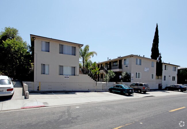
Property Record
7033 Boulevard Dr, La Mesa, CA 91941


NEARBY LISTINGS FOR SALE OR LEASE
Property Detail
7033 Boulevard Dr
San Diego-Chula Vista-Carlsbad, CA
Vista La Mesa
474-170-05
BLK O LOT 5 TR 002113
Multifamilydwelling
San Diego
X
California
06073C1643J
5
2024
0.18 AC
2025
La Mesa
014500
San Diego
3,320 SF
DEMOGRAPHICS near 7033 Boulevard Dr
1 Mile
3 Mile
5 Mile
2024 Total Population
23,524
212,270
524,432
2029 Population
23,262
210,446
519,882
Pop Growth 2024-2029
(1.11%)
(0.86%)
(0.87%)
Average Age
38
38
38
2024 Total Households
8,641
73,348
183,425
HH Growth 2024-2029
(1.33%)
(0.99%)
(0.97%)
Median Household Inc
$76,720
$70,089
$76,860
Avg Household Size
2.60
2.70
2.70
2024 Avg HH Vehicles
2.00
2.00
2.00
Median Home Value
$693,080
$683,560
$683,344
Median Year Built
1957
1968
1970
Nearby Places
Map Layers
Map Styles
 Street
 Aerial
- Restaurants
- Banks
- Shops
- Fitness
- Groceries
PUBLIC TRANSPORTATION
COMMUTER RAIL
San Diego (Santa Fe Depot) (Coaster - San Diego North County Transit District (Coaster/Sprinter/Breeze))
DRIVE
WALK
Distance
San Diego (Santa Fe Depot) (Coaster - San Diego North County Transit District (Coaster/Sprinter/Breeze))
14 min
9.6 mi
AIRPORT
San Diego International
DRIVE
WALK
Distance
San Diego International
17 min
12.0 mi
Freight Ports
Port of San Diego
DRIVE
WALK
Distance
Port of San Diego
15 min
9.3 mi
Nearby Properties
Address
Land Use
TOTAL SIZE
Lot Size
Zoning
Address
Land Use
TOTAL SIZE
Lot Size
Zoning
30.38 AC
RB
Address
Land Use
TOTAL SIZE
Lot Size
Zoning
8.23 AC
CUPD-CU-2-
Address
Land Use
TOTAL SIZE
Lot Size
Zoning
62.04 AC
C
Address
Land Use
TOTAL SIZE
Lot Size
Zoning
6.79 AC
C
Address
Land Use
TOTAL SIZE
Lot Size
Zoning
6.68 AC
RM-3-7
Address
Land Use
TOTAL SIZE
Lot Size
Zoning
4.77 AC
C
Address
Land Use
TOTAL SIZE
Lot Size
Zoning
5.02 AC
RM-4-10
Address
Land Use
TOTAL SIZE
Lot Size
Zoning
8.65 AC
R3
Address
Land Use
TOTAL SIZE
Lot Size
Zoning
135,165 SF
12.24 AC
CC-5-3
Address
Land Use
TOTAL SIZE
Lot Size
Zoning
92,500 SF
7.05 AC
R3
Address
Land Use
TOTAL SIZE
Lot Size
Zoning
1.54 AC
RM-3-9
Address
Land Use
TOTAL SIZE
Lot Size
Zoning
2.82 AC
R3
Address
Land Use
TOTAL SIZE
Lot Size
Zoning
4.10 AC
RB
Address
Land Use
TOTAL SIZE
Lot Size
Zoning
11.28 AC
C
Address
Land Use
TOTAL SIZE
Lot Size
Zoning
5.47 AC
R3
Address
Land Use
TOTAL SIZE
Lot Size
Zoning
6.14 AC
R3
Address
Land Use
TOTAL SIZE
Lot Size
Zoning
2.39 AC
RM-3-9
Address
Land Use
TOTAL SIZE
Lot Size
Zoning
98,463 SF
0.98 AC
RM-3-9
Address
Land Use
TOTAL SIZE
Lot Size
Zoning
60,480 SF
0.18 AC
RM-3-9
Address
Land Use
TOTAL SIZE
Lot Size
Zoning
84,900 SF
3.54 AC
R3
Address
Land Use
TOTAL SIZE
Lot Size
Zoning
89,332 SF
1.14 AC
C
Address
Land Use
TOTAL SIZE
Lot Size
Zoning
4.73 AC
RM-4-10
Address
Land Use
TOTAL SIZE
Lot Size
Zoning
17.63 AC
RM-1-3
Address
Land Use
TOTAL SIZE
Lot Size
Zoning
63,964 SF
5.25 AC
R3
Address
Land Use
TOTAL SIZE
Lot Size
Zoning
53,790 SF
0.98 AC
RM-3-9
Address
Land Use
TOTAL SIZE
Lot Size
Zoning
53,798 SF
1 AC
RM-3-9
Address
Land Use
TOTAL SIZE
Lot Size
Zoning
97,270 SF
3.40 AC
RM-3-7
Address
Land Use
TOTAL SIZE
Lot Size
Zoning
1.93 AC
RM-3-9
Address
Land Use
TOTAL SIZE
Lot Size
Zoning
51,780 SF
0.96 AC
RM-3-9
Address
Land Use
TOTAL SIZE
Lot Size
Zoning
96,664 SF
1.63 AC
CIVIC CENT
The World's #1 Commercial Real Estate Marketplace
Connect with us
© 2026 CoStar Group
The information above has been obtained from sources believed reliable. While we do not doubt its accuracy we have not verified it and make no guarantee, warranty or representation about it. It is your responsibility to independently confirm its accuracy and completeness. Any projections, opinions, assumptions, or estimates used are for example only and do not represent the current or future performance of the property. The value of this transaction to you depends on tax and other factors which should be evaluated by your tax, financial, and legal advisors. You and your advisors should conduct a careful, independent investigation of the property to determine to your satisfaction the suitability of the property for your needs.